Kiryū, Gunma
| Kiryū 桐生市 | |||
|---|---|---|---|
| City | |||
|
Kiryū city hall | |||
| |||
 Location of Kiryū in Gunma Prefecture | |||
 Kiryū
| |||
| Coordinates: 36°24′18.6″N 139°29′50.1″E / 36.405167°N 139.497250°ECoordinates: 36°24′18.6″N 139°29′50.1″E / 36.405167°N 139.497250°E | |||
| Country | Japan | ||
| Region | Kantō | ||
| Prefecture | Gunma Prefecture | ||
| Area | |||
| • Total | 274.45 km2 (105.97 sq mi) | ||
| Population (February 2015) | |||
| • Total | 114,924 | ||
| • Density | 419/km2 (1,090/sq mi) | ||
| Time zone | Japan Standard Time (UTC+9) | ||
| - Tree | Sweet Osmanthus | ||
| - Flower | Salvia splendens | ||
| Phone number | 0277-46-1111 | ||
| Address | 1-1 Orihimechō, Kiryū, Gunma-ken 376-8501 | ||
| Website | Official website | ||


Kiryū (桐生市 Kiryū-shi) is a city located in eastern Gunma Prefecture in the northern Kantō region of Japan. As of February 2015, the city had an estimated population of 114,924 and a population density of 419 persons per km². Its total area was 274.45 km².
Geography
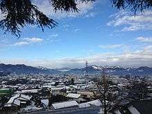
Kiryū is in the southeast part of Gunma, in the northern Kanto Plain near the Tochigi border. It is located approximately 100 kilometres (62 mi) northwest of Tokyo. The city is also not far from Mount Akagi, a large but dormant volcano. The city consists of two separate geographic areas, with the city of Midori sandwiched in between. Situated at the foot of Mount Akagi, the city boasts one of the most beautiful settings in the Kantō region. Two rivers, the Kiryū and the Watarase River, run through the heart of the city and it is likewise surrounded by picturesque mountains to the north. Umeda, a district on the north side of the city, is well known for its cedar trees, while red pines are also common in other areas.
Surrounding municipalities
History
During the Edo period, most of the area of present-day Kiryū was part of the tenryō holding under the direct administration of the Tokugawa shogunate in Kōzuke Province, with the exception of the commercial center and temple town of Kiryū-shinmachi, noted for sericulture since the Nara period, which was part of Shōnai Domain of Dewa Province. The area also prospered from its location on the Kiryū and Watarase rivers.
Modern Kiryū Town was created within Yamada District, Gunma Prefecture on April 1, 1889 with the creation of the municipalities system after the Meiji Restoration. It was raised to city status on March 1, 1921. Kiryū annexed the neighboring village of Sakaino on April 1, 1933 and village of Hirosawa on April 1, 1937. The city expanded further with the annexation of Umeda, Aioi and part of Kawauchi village on October 1, 1954.
On June 13, 2005, Kiryū absorbed the villages of Niisato and Kurohone (both from Seta District).
Economy
Traditionally, Kiryū's principal industry was sericulture and silk textile manufacturing, with records dating silk production as far back as 713. Pachinko manufacturing arrived in Kiryū after World War II, during the period of industrial reconstruction, with the formation of two main companies—the Heiwa Corporation in 1949, and the Sophia Corporation in 1951. Kiryū's factories are responsible for manufacturing 60% of Japan's pachinko machines. However, the decreased demand for silk goods and the closure of several area manufacturing concerns have caused the local economy to suffer.
Mitsuba Corporation, a major manufacturer of automotive parts is headquartered in the city.[1]
Education
There are six public and two private high schools, ten public and two private middle schools, and seventeen public elementary schools in Kiryū. Gunma University School of Science and Technology is located in the Tenjin district of the city.
Transportation
Railway
- JR East – Ryōmō Line
- Watarase Keikoku Railway – Watarase Keikoku Line
- Kiryū - Shimo-Shinden - Aioi - Undō-Kōen – (Ōmama - Kami-Kambai) - Motojuku - Mizunuma
- Jōmō Electric Railway Company - Jōmō Line
- Niisato - Nikkawa - Higashi-Nikkawa – (Akagi ) - Kiryū-Kyūjō-Mae - Tennōjuku - Fujiyamashita - Maruyamashita - Nishi-Kiryū
- Tobu Railway – Tōbu Kiryū Line
Highway
Local attractions
Having been virtually untouched by bombs during World War II, the city boasts one of the greatest concentrations of pre-war architecture in all of Japan.
- Kiryugaoka Amusement Park
- Kiryugaoka Zoo
- Kiryu Nature Sanctuary
- Kiryu Motorboat Race Course
- Gunma Insect World
- Okawa Museum of Art
- Textile Museum Yukari
- Tenmangu Shrine
Saw-tooth roof structures

Kiryu is especially known in the area for saw-tooth roof structures. The official mascot of Kiryu city is a saw-tooth themed character named Kinopi (キノピー). Many of these saw-tooth structures are still in use today, repurposed for various businesses.

Sister-city relations
-
 - Hitachi, Ibaraki, since June 18, 1965
 -
 - Biella, Piemonte, Italy, since October 12, 1963
  - Columbus, Georgia, United States of America, since June 16, 1977
- - Naruto, Tokushima, since September 18, 1980
Noted people from Kiryu
- Kenkichi Iwasawa (1917-1998), mathematician
- Mao Murakami (born 1995), dancer
- Naoki Matsuda (1977-2011), professional soccer player
- Shūzō Oshimi (born 1981), manga artist
- Ryoko Shinohara (born 1973), actress
- Chihiro Yamanaka (born 1976), pianist
- Saori Yuki (born 1948), singer
- Yukio Araki (1928-1945), youngest-known Japanese Kamikaze pilot killed in World War II
References
- ↑ "Head Quarter, Offices and Plants." Mitsuba Corporation. Retrieved on August 20, 2014.
External links
| Wikimedia Commons has media related to Kiryu, Gunma. |
-
 Kiryu travel guide from Wikivoyage
 - Official website (Japanese)
- Kiryu International Exchange Association (English) (Japanese)
| Core cities | ||
|---|---|---|
| Special cities | ||
| Cities | ||
| Agatsuma District | ||
| Kanra District | ||
| Kitagunma District | ||
| Ōra District | ||
| Sawa District | ||
| Tano District | ||
| Tone District | ||