Kramer Junction, California
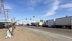
The intersection at Kramer Junction
| Kramer Junction | |
|---|---|
| Unincorporated community | |
| Nickname(s): Four Corners | |
| Country | United States |
| State | California |
| County | San Bernardino |
| Population | |
| • Total | 2,231 |
| Time zone | PST |
| ZIP code | 93516 |
| Area code(s) | 760 |
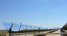
Parabolic trough power plant for electricity production, near Kramer Junction in California's Mojave Desert.
Kramer Junction (also known as "Four Corners") is an unincorporated community in San Bernardino County, California. Kramer Junction is located in the Mojave Desert at the intersection of U.S. Route 395 and State Route 58, 2.3 miles (3.7 km) east of Kramer.[1] As of the 2000 census, Kramer Junction had a total population of 2,231.[2]
Solar Energy Generating Systems sites SEGS III-VII are located less than a mile to the northwest.
The United States Air Force once maintained a communications relay station east of Kramer Junction at Hawes airfield, known as the Hawes Radio Tower, that had an antenna tower in excess of 1,200 feet tall. This tower was removed in the 1980s.
References
- ↑ "Kramer Junction". Geographic Names Information System. United States Geological Survey.
- ↑ "USA.com : Location information of the United States". Zipareacode.net. Retrieved 2013-10-24.
Coordinates: 34°59′33″N 117°32′30″W / 34.99250°N 117.54167°W
This article is issued from Wikipedia - version of the 4/29/2016. The text is available under the Creative Commons Attribution/Share Alike but additional terms may apply for the media files.