Kunlun Mountains
| Kunlun Mountains | |
|---|---|
| 崑崙山 | |
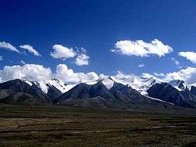 View of Western Kunlun Shan from the Tibet-Xinjiang highway | |
| Highest point | |
| Peak | Kongur Tagh |
| Elevation | 7,649 m (25,095 ft) |
| Naming | |
| Native name | Kūnlún Shān |
| Geography | |
| Country | China |
| State/Province | Tibet, Qinghai, Xinjiang |
| Range coordinates | 36°N 84°E / 36°N 84°ECoordinates: 36°N 84°E / 36°N 84°E |
| Borders on | Gobi Desert |
| Kunlun Mountains | |||||||||
.svg.png) "Kunlun" in Simplified (top) and Traditional (bottom) Chinese characters | |||||||||
| Simplified Chinese | 昆仑山 | ||||||||
|---|---|---|---|---|---|---|---|---|---|
| Traditional Chinese | 崑崙山 | ||||||||
| Postal | Kwenlun Mountains | ||||||||
| |||||||||
The Kunlun Mountains (simplified Chinese: 昆仑山; traditional Chinese: 崑崙山; pinyin: Kūnlún Shān, pronounced [kʰu̯ə́nlu̯ə̌n ʂán]; Mongolian: Хөндлөн Уулс Hundlun) are one of the longest mountain chains in Asia, extending more than 3,000 kilometres (1,900 mi). In the broadest sense, it forms the northern edge of the Tibetan Plateau south of the Tarim Basin and the Gansu Corridor and continues east south of the Wei River to end at the North China Plain.
The exact definition of this range varies. An old source[1] uses Kunlun to mean the mountain belt that runs across the center of China, that is, Kunlun in the narrow sense: Altyn Tagh along with the Qilian and Qin Mountains. A recent source [2] has the Kunlun range forming most of the south side of the Tarim Basin and then continuing east south of the Altyn Tagh. Sima Qian (Shiji, scroll 123) says that Emperor Wu of Han sent men to find the source of the Yellow River and gave the name Kunlun to the mountains at its source. The name seems to have originated as a semi-mythical location in the classical Chinese text Shanhai Jing.
Extent
From the Pamirs of Tajikistan, it runs east along the border between Xinjiang and Tibet autonomous regions to the Sino-Tibetan ranges in Qinghai province.[3] It stretches along the southern edge of what is now called the Tarim Basin, the infamous Takla Makan or "sand-buried houses" desert, and the Gobi Desert. A number of important rivers flow from it including the Karakash River ('Black Jade River') and the Yurungkash River ('White Jade River'), which flow through the Khotan Oasis into the Taklamakan Desert.
Altyn-Tagh or Altun Range is one of the chief northern ranges of the Kunlun. Its eastern extension Qilian Shan is another main northern range of the Kunlun. In the south main extension is the Min Shan. Bayan Har Mountains, a southern branch of the Kunlun Mountains, forms the watershed between the catchment basins of China's two longest rivers, the Yangtze River and the Yellow River.
The highest mountain of the Kunlun Shan is the Kunlun Goddess (7,167 m) in the Keriya area. The Arka Tagh (Arch Mountain) is in the center of the Kunlun Shan; its highest point is Ulugh Muztagh (6,973 m). Some authorities claim that the Kunlun extends northwest-wards as far as Kongur Tagh (7,649 m) and the famous Muztagh Ata (7,546 m). But these mountains are physically much more closely linked to the Pamir group (ancient Mount Imeon).
The mountain range formed at the northern edges of the Cimmerian Plate during its collision, in the Late Triassic, with Siberia, which resulted in the closing of the Paleo-Tethys Ocean.
The range has very few roads and in its 3,000 km length is crossed by only two. In the west, Highway 219 traverses the range en route from Yecheng, Xinjiang to Lhatse, Tibet. Further east, Highway 109 crosses between Lhasa and Golmud.
Kunlun Volcanic Group
Over 70 volcanic cones form the Kunlun Volcanic Group. They are not volcanic mountains, but cones. As such, they are not counted among the world volcanic mountain peaks. The group, however, musters the heights of 5,808 metres (19,055 ft) above sea level (35°30′N 80°12′E / 35.5°N 80.2°E). If they were considered volcanic mountains, they would constitute the highest volcano in Asia and China and second highest in the Eastern Hemisphere (after Mount Kilimanjaro) and one of Volcanic Seven Summits by elevation. (Mount Damavand is the highest volcano in Asia, not the Kunlun cones.) The last known eruption in the volcanic group was on May 27, 1951.[4]
Mythology
Kunlun is originally the name of a mythical mountain believed to be a paradise of Taoism. The first to visit this paradise was, according to the legends, King Mu (976-922 BCE) of the Zhou Dynasty. He supposedly discovered there the Jade Palace of Yellow Emperor, the mythical originator of Chinese culture, and met Hsi Wang Mu (Xi Wang Mu), the 'Spirit Mother of the West' usually called the 'Queen Mother of the West', who was the object of an ancient religious cult which reached its peak in the Han Dynasty, also had her mythical abode in these mountains.
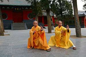
Kunlun martial arts
| Part of a series on |
| Chinese martial arts (Wushu) |
|---|
 |
|
Styles of Chinese martial arts
|
| Wushu in the world |
|
Historical locations Chen Village (陳家溝) |
| Wushu athletes/practitioners |
|
Legendary figures Bodhidharma (菩提達摩) |
|
Historical individuals Yue Fei (岳飛; 1103—1142) |
|
Modern celebrities Bruce Lee (李小龍 1940—1973) |
| Wushu influence |
|
Related |
The Kunlun mountains are associated with a number of different martial arts, and are considered by some as an alternate source for the Daoist martial arts (Wudang being traditionally claimed as the source.) Some styles associated with the Kunlun mountains:
Kunlun Mountain Fist is a style associated with the Kunlun mountain range, although similarities between this style and Kunlunquan, as well as the name of one of the forms (White Cloud Mountain Fist) suggest that this style may be associated with Kunlun Mountain in Shandong province
Kunlunquan may be named after the Kunlun mountain range, or it may be named after Kunlun Mountain in Shandong province.
Gallery
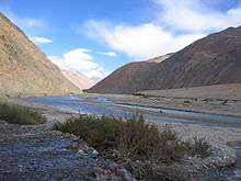 Karakash River in the Western Kunlun Shan, seen from the Tibet-Xinjiang highway
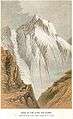 Peak in Kunlun range
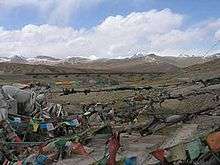 The Kunlun Pass
See also
References
- ↑ L. Richard, 'Comprehensive Geography of the Chinese Empire',1905
- ↑ National Geographic Atlas of China,2008
- ↑ "Kunlun Mountains". Encyclopædia Britannica. Retrieved 2009-11-19.
- ↑ "Kunlun Volcanic Group". Global Volcanism Program. Smithsonian Institution. Retrieved 2014-03-15.
Further reading
- Munro-Hay, Stuart Aksum. Edinburgh: University Press. 1991. ISBN 0-7486-0106-6
External links
| Wikimedia Commons has media related to Kunlun Mountains. |
Mountain ranges of China | |
|---|---|
| Northwest China | |
| Qinghai-Tibet and Southwest China | |
| Northeast China | |
| Northern China | |
| Central China | |
| Southern China | |