La Bruyère, Belgium
| La Bruyère | ||
|---|---|---|
| Municipality | ||
_JPG00.jpg) | ||
| ||
 La Bruyère Location in Belgium | ||
|
Location of La Bruyère in the province of Namur 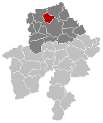 | ||
| Coordinates: 50°30′N 04°48′E / 50.500°N 4.800°ECoordinates: 50°30′N 04°48′E / 50.500°N 4.800°E | ||
| Country | Belgium | |
| Community | French Community | |
| Region | Wallonia | |
| Province | Namur | |
| Arrondissement | Namur | |
| Government | ||
| • Mayor | Robert Cappe (MR) | |
| • Governing party/ies | MR, PS | |
| Area | ||
| • Total | 52.98 km2 (20.46 sq mi) | |
| Population (1 January 2016)[1] | ||
| • Total | 9,060 | |
| • Density | 170/km2 (440/sq mi) | |
| Postal codes | 5080-5081 | |
| Area codes | 081 | |
| Website | www.la-bruyère.be | |

La Bruyère (French: [la bʁɥi.jɛʁ]) is a Walloon municipality of Belgium located in the province of Namur. It consists of the former municipalities of Émines, Rhisnes, Villers-lez-Heest, Warisoulx, Bovesse, Meux and Saint-Denis-Bovesse. The village of Rhisnes is the administrative centre of the municipality.
_050809_(1).JPG)
Saint-Denis-Bovesse (La Bruyère), the church.
See also
References
- ↑ Population per municipality as of 1 January 2016 (XLS; 397 KB)
External links
-
 Media related to La Bruyère, Belgium at Wikimedia Commons
 - Official website (in French)
 |
Éghezée | | ||
| Gembloux | |
Namur | ||
| ||||
| | ||||
| Namur |
Municipalities in the Province of Namur | ||
|---|---|---|
| Dinant |  | |
| Namur | ||
| Philippeville | ||
This article is issued from Wikipedia - version of the 12/1/2016. The text is available under the Creative Commons Attribution/Share Alike but additional terms may apply for the media files.