La Chapelle-d'Alagnon
| La Chapelle-d'Alagnon | |
|---|---|
|
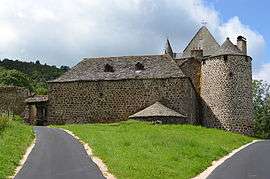
The Château of Jarrousset | |
 La Chapelle-d'Alagnon | |
|
Location within Auvergne-Rhône-Alpes region  La Chapelle-d'Alagnon | |
| Coordinates: 45°06′30″N 2°53′50″E / 45.1083°N 2.8972°ECoordinates: 45°06′30″N 2°53′50″E / 45.1083°N 2.8972°E | |
| Country | France |
| Region | Auvergne-Rhône-Alpes |
| Department | Cantal |
| Arrondissement | Saint-Flour |
| Canton | Murat |
| Intercommunality | Pays de Murat |
| Government | |
| • Mayor (2008–2014) | Philippe Coudon |
| Area1 | 9.2 km2 (3.6 sq mi) |
| Population (2008)2 | 240 |
| • Density | 26/km2 (68/sq mi) |
| Time zone | CET (UTC+1) |
| • Summer (DST) | CEST (UTC+2) |
| INSEE/Postal code | 15041 / 15300 |
| Elevation |
860–1,124 m (2,822–3,688 ft) (avg. 882 m or 2,894 ft) |
|
1 French Land Register data, which excludes lakes, ponds, glaciers > 1 km² (0.386 sq mi or 247 acres) and river estuaries. 2 Population without double counting: residents of multiple communes (e.g., students and military personnel) only counted once. | |
La Chapelle-d'Alagnon is a commune in the Cantal department in south-central France.
Population
| Historical population | ||
|---|---|---|
| Year | Pop. | ±% |
| 1962 | 256 | — |
| 1968 | 264 | +3.1% |
| 1975 | 239 | −9.5% |
| 1982 | 246 | +2.9% |
| 1990 | 236 | −4.1% |
| 1999 | 250 | +5.9% |
| 2008 | 240 | −4.0% |
See also
References
| Wikimedia Commons has media related to La Chapelle-d'Alagnon. |
This article is issued from Wikipedia - version of the 2/15/2015. The text is available under the Creative Commons Attribution/Share Alike but additional terms may apply for the media files.