La Chapelle-sur-Coise
| La Chapelle-sur-Coise | |
|---|---|
|
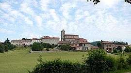
The church and surrounding buildings in La Chapelle-sur-Coise | |
 La Chapelle-sur-Coise | |
|
Location within Auvergne-Rhône-Alpes region  La Chapelle-sur-Coise | |
| Coordinates: 45°39′20″N 4°30′02″E / 45.6556°N 4.5006°ECoordinates: 45°39′20″N 4°30′02″E / 45.6556°N 4.5006°E | |
| Country | France |
| Region | Auvergne-Rhône-Alpes |
| Department | Rhône |
| Arrondissement | Villefranche-sur-Saône |
| Canton | Vaugneray |
| Intercommunality | Communauté de communes des Hauts du Lyonnais |
| Government | |
| • Mayor (2008–2014) | Raymond Pupier |
| Area1 | 6.58 km2 (2.54 sq mi) |
| Population (1999)2 | 382 |
| • Density | 58/km2 (150/sq mi) |
| Time zone | CET (UTC+1) |
| • Summer (DST) | CEST (UTC+2) |
| INSEE/Postal code | 69042 / 69590 |
| Elevation |
599–784 m (1,965–2,572 ft) (avg. 700 m or 2,300 ft) |
|
1 French Land Register data, which excludes lakes, ponds, glaciers > 1 km² (0.386 sq mi or 247 acres) and river estuaries. 2 Population without double counting: residents of multiple communes (e.g., students and military personnel) only counted once. | |
La Chapelle-sur-Coise is a commune in the Rhône department in eastern France.
See also
Communes of the Rhône department
References
| Wikimedia Commons has media related to La Chapelle-sur-Coise. |
This article is issued from Wikipedia - version of the 2/12/2016. The text is available under the Creative Commons Attribution/Share Alike but additional terms may apply for the media files.