Saint-Vérand, Rhône
| Saint-Vérand | ||
|---|---|---|
|
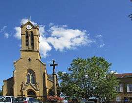
The church in Saint-Vérand | ||
| ||
 Saint-Vérand | ||
|
Location within Auvergne-Rhône-Alpes region  Saint-Vérand | ||
| Coordinates: 45°55′11″N 4°31′41″E / 45.9197°N 4.5281°ECoordinates: 45°55′11″N 4°31′41″E / 45.9197°N 4.5281°E | ||
| Country | France | |
| Region | Auvergne-Rhône-Alpes | |
| Department | Rhône | |
| Arrondissement | Villefranche-sur-Saône | |
| Canton | Le Bois-d'Oingt | |
| Government | ||
| • Mayor (2008–2014) | Gérard Chardon | |
| Area1 | 17.58 km2 (6.79 sq mi) | |
| Population (2006)2 | 1,082 | |
| • Density | 62/km2 (160/sq mi) | |
| Time zone | CET (UTC+1) | |
| • Summer (DST) | CEST (UTC+2) | |
| INSEE/Postal code | 69239 / 69620 | |
| Elevation |
258–686 m (846–2,251 ft) (avg. 385 m or 1,263 ft) | |
|
1 French Land Register data, which excludes lakes, ponds, glaciers > 1 km² (0.386 sq mi or 247 acres) and river estuaries. 2 Population without double counting: residents of multiple communes (e.g., students and military personnel) only counted once. | ||
.svg.png)
Saint-Vérand is a commune in the Rhône department in eastern France.
See also
References
| Wikimedia Commons has media related to Saint-Vérand (Rhône). |
This article is issued from Wikipedia - version of the 2/11/2016. The text is available under the Creative Commons Attribution/Share Alike but additional terms may apply for the media files.