Ternay, Rhône
| Ternay | ||
|---|---|---|
|
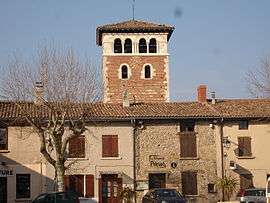
The main square and the church tower | ||
| ||
 Ternay | ||
|
Location within Auvergne-Rhône-Alpes region  Ternay | ||
| Coordinates: 45°36′11″N 4°48′41″E / 45.6031°N 4.8114°ECoordinates: 45°36′11″N 4°48′41″E / 45.6031°N 4.8114°E | ||
| Country | France | |
| Region | Auvergne-Rhône-Alpes | |
| Department | Rhône | |
| Arrondissement | Villefranche-sur-Saône | |
| Canton | Saint-Symphorien-d'Ozon | |
| Intercommunality | Communauté de communes du Pays de l'Ozon | |
| Government | ||
| • Mayor (2008–2014) | Jean-Jacques Brun | |
| Area1 | 8.06 km2 (3.11 sq mi) | |
| Population (2005)2 | 5,023 | |
| • Density | 620/km2 (1,600/sq mi) | |
| Time zone | CET (UTC+1) | |
| • Summer (DST) | CEST (UTC+2) | |
| INSEE/Postal code | 297 69 297 / 69 360 | |
| Elevation |
153–281 m (502–922 ft) (avg. 208 m or 682 ft) | |
|
1 French Land Register data, which excludes lakes, ponds, glaciers > 1 km² (0.386 sq mi or 247 acres) and river estuaries. 2 Population without double counting: residents of multiple communes (e.g., students and military personnel) only counted once. | ||
.svg.png)
Ternay is a commune in the Rhône department in eastern France.
See also
References
| Wikimedia Commons has media related to Ternay (Rhône). |
This article is issued from Wikipedia - version of the 10/28/2016. The text is available under the Creative Commons Attribution/Share Alike but additional terms may apply for the media files.