Lamure-sur-Azergues
| Lamure-sur-Azergues | ||
|---|---|---|
|
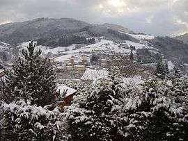
Lamure-sur-Azergues in the snow in November 2010 | ||
| ||
 Lamure-sur-Azergues | ||
|
Location within Auvergne-Rhône-Alpes region  Lamure-sur-Azergues | ||
| Coordinates: 46°03′47″N 4°29′34″E / 46.0631°N 4.4928°ECoordinates: 46°03′47″N 4°29′34″E / 46.0631°N 4.4928°E | ||
| Country | France | |
| Region | Auvergne-Rhône-Alpes | |
| Department | Rhône | |
| Arrondissement | Villefranche-sur-Saône | |
| Canton | Tarare | |
| Intercommunality | Communauté de Communes de la Haute Vallée d'Azergues | |
| Government | ||
| • Mayor (2008–2014) | Bernard Rossier | |
| Area1 | 15.61 km2 (6.03 sq mi) | |
| Population (2007)2 | 1,055 | |
| • Density | 68/km2 (180/sq mi) | |
| Time zone | CET (UTC+1) | |
| • Summer (DST) | CEST (UTC+2) | |
| INSEE/Postal code | 69107 / 69870 | |
| Elevation |
351–885 m (1,152–2,904 ft) (avg. 383 m or 1,257 ft) | |
|
1 French Land Register data, which excludes lakes, ponds, glaciers > 1 km² (0.386 sq mi or 247 acres) and river estuaries. 2 Population without double counting: residents of multiple communes (e.g., students and military personnel) only counted once. | ||
.svg.png)
Lamure-sur-Azergues is a commune in the Rhône department in eastern France.
See also
References
| Wikimedia Commons has media related to Lamure-sur-Azergues. |
This article is issued from Wikipedia - version of the 3/15/2016. The text is available under the Creative Commons Attribution/Share Alike but additional terms may apply for the media files.