Saint-Didier-sous-Riverie
| Saint-Didier-sous-Riverie | |
|---|---|
|
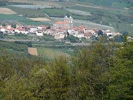
The village of Saint-Didier-sous-Riverie in the middle of orchards. | |
 Saint-Didier-sous-Riverie | |
|
Location within Auvergne-Rhône-Alpes region  Saint-Didier-sous-Riverie | |
| Coordinates: 45°35′51″N 4°36′33″E / 45.5975°N 4.6092°ECoordinates: 45°35′51″N 4°36′33″E / 45.5975°N 4.6092°E | |
| Country | France |
| Region | Auvergne-Rhône-Alpes |
| Department | Rhône |
| Arrondissement | Villefranche-sur-Saône |
| Canton | Mornant |
| Intercommunality | Communauté de communes du Pays Mornantais |
| Government | |
| • Mayor (2008–2014) | Christine Perrot |
| Area1 | 13.9 km2 (5.4 sq mi) |
| Population (2006)2 | 1,173 |
| • Density | 84/km2 (220/sq mi) |
| Time zone | CET (UTC+1) |
| • Summer (DST) | CEST (UTC+2) |
| INSEE/Postal code | 69195 / 69440 |
| Elevation |
340–750 m (1,120–2,460 ft) (avg. 521 m or 1,709 ft) |
|
1 French Land Register data, which excludes lakes, ponds, glaciers > 1 km² (0.386 sq mi or 247 acres) and river estuaries. 2 Population without double counting: residents of multiple communes (e.g., students and military personnel) only counted once. | |
Saint-Didier-sous-Riverie is a commune in the Rhône department in eastern France.
See also
References
| Wikimedia Commons has media related to Saint-Didier-sous-Riverie. |
This article is issued from Wikipedia - version of the 2/11/2016. The text is available under the Creative Commons Attribution/Share Alike but additional terms may apply for the media files.