Lake and Peninsula Borough, Alaska
| Lake and Peninsula Borough, Alaska | |
|---|---|
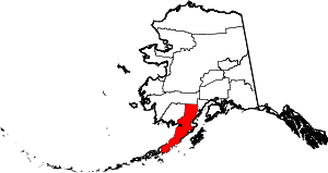 Location in the U.S. state of Alaska | |
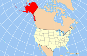 Alaska's location in the U.S. | |
| Incorporated | April 26, 1989[1][2] |
| Seat | King Salmon |
| Largest city | Nondalton |
| Area | |
| • Total | 32,922 sq mi (85,268 km2) |
| • Land | 23,652 sq mi (61,258 km2) |
| • Water | 9,270 sq mi (24,009 km2), 28.2% |
| Population (est.) | |
| • (2015) | 1,563 |
| • Density | 0.1/sq mi (0/km²) |
| Congressional district | At-large |
| Time zone | Alaska: UTC-9/-8 |
| Website |
www |
Lake and Peninsula Borough is a borough in the state of Alaska. As of the 2010 census, the population was 1,631.[3] The borough seat of King Salmon[4] is located in neighboring Bristol Bay Borough, although is not the seat of that borough. The most populous community in the borough is the city of Nondalton. With an average of 0.0296 inhabitants/km² (0.0767/sq mi), the Lake and Peninsula Borough is the second least densely populated organized county-equivalent in the United States; only the unorganized Yukon-Koyukuk Census Area has a lower density.
Geography
The borough has an area of 32,922 square miles (85,270 km2), of which 23,652 square miles (61,260 km2) is land and 9,270 square miles (24,000 km2) (28.2%) is water.[5] Its land area is larger than that of San Bernardino County, California, the largest county in the contiguous Lower 48 states, and almost as large as the state of West Virginia.
Adjacent boroughs and census areas
- Bethel Census Area, Alaska - north
- Kenai Peninsula Borough, Alaska - east
- Kodiak Island Borough, Alaska - southeast
- Aleutians East Borough, Alaska - west
- Bristol Bay Borough, Alaska - west
- Dillingham Census Area, Alaska - west
National protected areas
- Alagnak Wild River
- Alaska Maritime National Wildlife Refuge (part of the Alaska Peninsula unit)
- Alaska Peninsula National Wildlife Refuge (part)
- Aniakchak National Monument and Preserve
- Becharof National Wildlife Refuge (part)
- Becharof Wilderness (part)
- Katmai National Park and Preserve (part)
- Katmai Wilderness (part)
- Lake Clark National Park and Preserve (part)
- Lake Clark Wilderness (part)
Demographics
| Historical population | |||
|---|---|---|---|
| Census | Pop. | %± | |
| 1990 | 1,668 | — | |
| 2000 | 1,823 | 9.3% | |
| 2010 | 1,631 | −10.5% | |
| Est. 2015 | 1,563 | [6] | −4.2% |
| U.S. Decennial Census[7] 1990-2000[8] 2010-2015[3] | |||
As of the census[9] of 2000, there were 1,823 people, 588 households, and 418 families residing in the borough. The population density was 0.059 people per square mile (0.023/km²). There were 1,557 housing units at an average density of 0.05 per square mile (0.02/km²). The racial makeup of the borough was 18.76% White, 0.05% Black or African American, 73.51% Native American, 0.22% Asian, 0.16% Pacific Islander, 0.33% from other races, and 6.97% from two or more races. 1.15% of the population were Hispanic or Latino of any race. About 5.41% reported speaking a Yupik language at home, while 3.87% speak Alutiiq and 1.23% an Athabaskan language .
Some 44.70% of households had children under the age of 18 living with them, 48.50% were married couples living together, 9.70% had a female householder with no husband present, and 28.90% were non-families. About 24.70% of all households were made up of individuals, and 3.90% consisted of a sole occupant 65 years of age or older. The average household size was 3.10 and the average family size was 3.74.
In the borough, the age of the population was spread out with 37.80% under the age of 18, 8.50% from 18 to 24, 28.00% from 25 to 44, 20.20% from 45 to 64, and 5.40% who were 65 years of age or older. The median age was 29 years. For every 100 females there were 113.50 males. For every 100 females age 18 and over, there were 124.10 males.
Cities and towns
See also
References
- ↑ "Substantial Changes to Counties and County Equivalent Entities: 1970–Present". United States Census Bureau, Geography Division. 24 May 2002. Retrieved 2012-05-04.
- ↑ 1996 Alaska Municipal Officials Directory. Juneau: Alaska Municipal League/Alaska Department of Community and Regional Affairs. January 1996. p. 11.
- 1 2 "State & County QuickFacts". United States Census Bureau. Retrieved May 17, 2014.
- ↑ "Find a County". National Association of Counties. Retrieved 2011-06-07.
- ↑ "US Gazetteer files: 2010, 2000, and 1990". United States Census Bureau. 2011-02-12. Retrieved 2011-04-23.
- ↑ "County Totals Dataset: Population, Population Change and Estimated Components of Population Change: April 1, 2010 to July 1, 2015". Retrieved July 2, 2016.
- ↑ "U.S. Decennial Census". United States Census Bureau. Retrieved May 17, 2014.
- ↑ "Census 2000 PHC-T-4. Ranking Tables for Counties: 1990 and 2000" (PDF). United States Census Bureau. Retrieved May 17, 2014.
- ↑ "American FactFinder". United States Census Bureau. Retrieved 2011-05-14.
External links
![]() Media related to Lake and Peninsula Borough, Alaska at Wikimedia Commons
Media related to Lake and Peninsula Borough, Alaska at Wikimedia Commons
 |
Bethel Census Area | | ||
| Aleutians East Borough, Bristol Bay Borough, and Dillingham Census Area | |
Kenai Peninsula Borough | ||
| ||||
| | ||||
| Kodiak Island Borough |
Municipalities and communities of Lake and Peninsula Borough, Alaska, United States | ||
|---|---|---|
| Cities | | |
| CDPs | ||
| Ghost town | ||
Juneau (capital) | ||
| Topics |
|  |
| Society |
| |
| Regions | ||
| Largest cities | ||
| Boroughs | ||
| Census Areas | ||
Coordinates: 58°24′N 156°11′W / 58.40°N 156.18°W