Lansing, Kansas
| Lansing, Kansas | ||
|---|---|---|
| City | ||
|
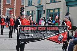
Lansing High School band marching in the 2015 Veterans Day Parade | ||
| ||
 Location within Leavenworth County and Kansas | ||
 KDOT map of Leavenworth County (legend) | ||
| Coordinates: 39°14′55″N 94°53′31″W / 39.24861°N 94.89194°WCoordinates: 39°14′55″N 94°53′31″W / 39.24861°N 94.89194°W | ||
| Country | United States | |
| State | Kansas | |
| County | Leavenworth | |
| Incorporated | 1959 | |
| Government | ||
| • Mayor | Gene Kirby | |
| • City Administrator | Tim Vandall [1] | |
| • City Clerk | Sarah Bodensteiner [2] | |
| Area[3] | ||
| • Total | 12.50 sq mi (32.37 km2) | |
| • Land | 12.39 sq mi (32.09 km2) | |
| • Water | 0.11 sq mi (0.28 km2) 0.88% | |
| Elevation | 846 ft (258 m) | |
| Population (2010)[4] | ||
| • Total | 11,265 | |
| • Estimate (2012[5]) | 11,591 | |
| • Density | 900/sq mi (350/km2) | |
| Time zone | CST (UTC-6) | |
| • Summer (DST) | CDT (UTC-5) | |
| ZIP code | 66043 | |
| Area code | 913 | |
| FIPS code | 20-38650 [6] | |
| GNIS feature ID | 0478431 [7] | |
| Website | Lansing.KS.us | |

Lansing is a city situated along the Missouri River in the eastern part of Leavenworth County, located in northeast Kansas, in the Central United States. As of the 2010 census, the city population was 11,265.[8] It is the second most populous city of Leavenworth County and is a part of the Kansas City metropolitan area.
The Lansing Correctional Facility (formerly the Kansas State Penitentiary), which includes the state's main maximum-security prison, is located in Lansing.

History
Lansing is named for James Lansing, a pioneer settler.[9] Formerly William Lansing Taylor, James changed his name upon his enlistment in 1862 as a hospital steward in the 7th Kansas Cavalry. Following the Civil War, he earned a position at the new state penitentiary in Kansas as a hospital steward. He later resigned and opened a general mercantile store, which held the post office and an apothecary business, in the area called “Town of Progress”. “Doc Lansing”, as he became known, and his friend John C. Schmidt became co-owners of 90 acres (360,000 m2) of land that was platted into town lots in 1878; they named the area “Town of Lansing”. Lansing did not become an incorporated city until 1959.[10]
The Kansas State Penitentiary, later renamed the Lansing Correctional Facility in 1990, was authorized by the Kansas Constitution in 1859; it is the state's largest and oldest facility for detention and rehabilitation of male adult felons.[10] With the opening of the coal mine at the prison the town became an important shipping point for this product.[11]
Lansing was ranked 88 in the top 100 of Money Magazine's 2007 list of best places to live.[12]
Geography
Lansing is located at 39°14′55″N 94°53′31″W / 39.24861°N 94.89194°W (39.248689, -94.891880).[13] The city is situated along the western bank of the Missouri River which also marks the Kansas-Missouri state border. It is bordered by the city of Leavenworth to the north; Kansas City is less than a half-hour to the southeast. U.S. Route 73 passes through the city.
According to the United States Census Bureau, the city has a total area of 12.50 square miles (32.37 km2), of which, 12.39 square miles (32.09 km2) is land and 0.11 square miles (0.28 km2) is water.[3]
Climate
The climate in this area is characterized by hot, humid summers and generally mild to cool winters. According to the Köppen Climate Classification system, Lansing has a humid subtropical climate, abbreviated "Cfa" on climate maps.[14]
Demographics
| Historical population | |||
|---|---|---|---|
| Census | Pop. | %± | |
| 1880 | 933 | — | |
| 1890 | 1,468 | 57.3% | |
| 1960 | 1,264 | — | |
| 1970 | 3,797 | 200.4% | |
| 1980 | 5,307 | 39.8% | |
| 1990 | 7,120 | 34.2% | |
| 2000 | 9,199 | 29.2% | |
| 2010 | 11,265 | 22.5% | |
| Est. 2015 | 11,767 | [15] | 4.5% |
| U.S. Decennial Census | |||
2010 census
As of the census[4] of 2010, there were 11,265 people, 3,180 households, and 2,496 families residing in the city. The population density was 909.2 inhabitants per square mile (351.0/km2). There were 3,371 housing units at an average density of 272.1 per square mile (105.1/km2). The racial makeup of the city was 80.2% White, 13.2% African American, 0.8% Native American, 2.0% Asian, 0.1% Pacific Islander, 0.8% from other races, and 2.8% from two or more races. Hispanic or Latino of any race were 5.1% of the population.
There were 3,180 households of which 41.9% had children under the age of 18 living with them, 62.4% were married couples living together, 11.8% had a female householder with no husband present, 4.3% had a male householder with no wife present, and 21.5% were non-families. 18.1% of all households were made up of individuals and 6.7% had someone living alone who was 65 years of age or older. The average household size was 2.79 and the average family size was 3.15.
The median age in the city was 37.6 years. 22.9% of residents were under the age of 18; 8.1% were between the ages of 18 and 24; 31.2% were from 25 to 44; 29.3% were from 45 to 64; and 8.3% were 65 years of age or older. The gender makeup of the city was 59.4% male and 40.6% female.
2000 census
As of the U.S. Census in 2000,[6] there were 9,199 people, 2,435 households, and 1,913 families residing in the city. The population density was 1,080.1 people per square mile (416.9/km²). There were 2,548 housing units at an average density of 299.2 per square mile (115.5/km²). The racial makeup of the city was 81.0% White, 12.5% Black or African American, 1.2% Native American, 1.3% Asian, 0.2% Pacific Islander, 1.3% from other races, and 2.6% from two or more races. Hispanic or Latino of any race were 3.9% of the population.
There were 2,435 households out of which 42.2% had children under the age of 18 living with them, 65.0% were married couples living together, 9.4% had a female householder with no husband present, and 21.4% were non-families. 18.4% of all households were made up of individuals and 7.1% had someone living alone who was 65 years of age or older. The average household size was 2.79 and the average family size was 3.17.
In the city the population was spread out with 22.0% under the age of 18, 8.8% from 18 to 24, 38.5% from 25 to 44, 23.1% from 45 to 64, and 7.5% who were 65 years of age or older. The median age was 36 years. For every 100 females there were 164.8 males. For every 100 females age 18 and over, there were 184.9 males.
The median income for a household in the city was $60,994, and the median income for a family was $65,639. Males had a median income of $36,326 versus $28,315 for females. The per capita income for the city was $21,655. About 1.9% of families and 2.4% of the population were below the poverty line, including 1.5% of those under age 18 and 3.5% of those age 65 or over.
Education
Lansing Unified School District (USD 469), with three schools, serves more than 2,000 students.[16]
- Lansing Elementary School, grades K–5
- Lansing Middle School, grades 6–8
- Lansing High School, grades 9–12
Notable people
- Chris Burnett, American jazz saxophone player, composer, and veteran of US military bands
- Adam Gnade "talking songs" artist
See also
References
- ↑ http://www.lansing.ks.us/Index.aspx?NID=24
- ↑ http://www.lansing.ks.us/6/City-Clerk
- 1 2 "US Gazetteer files 2010". United States Census Bureau. Retrieved 2012-07-06.
- 1 2 "American FactFinder". United States Census Bureau. Retrieved 2012-07-06.
- ↑ "Population Estimates". United States Census Bureau. Retrieved 2013-05-29.
- 1 2 "American FactFinder". United States Census Bureau. Retrieved 2008-01-31.
- ↑ "US Board on Geographic Names". United States Geological Survey. 2007-10-25. Retrieved 2008-01-31.
- ↑ "2010 City Population and Housing Occupancy Status". U.S. Census Bureau. Retrieved March 6, 2011.
- ↑ Heim, Michael (2007). Exploring Kansas Highways. p. 52. ISBN 9780974435886.
- 1 2 "Lansing History". City of Lansing. Retrieved 2006-07-16.
- ↑ Frank W. Blackmar, ed. (1912). "Atchison". Kansas: a cyclopedia of state history, embracing events, institutions, industries, counties, cities, towns, prominent persons, etc ... II. Chicago: Standard Pub Co. p. 104.
- ↑ Ashford, Kate; Bartz, Andrea; Cox, Jeff; Fitch, Asa; Gandel, Stephen; Hyatt, Josh; Kelley, Rob; Knight, Kathleen; et al. "Best Places to Live: Top 100". Money Magazine. Retrieved 2008-04-15.
- ↑ "US Gazetteer files: 2010, 2000, and 1990". United States Census Bureau. 2011-02-12. Retrieved 2011-04-23.
- ↑ Climate Summary for Lansing, Kansas
- ↑ "Annual Estimates of the Resident Population for Incorporated Places: April 1, 2010 to July 1, 2015". Retrieved July 2, 2016.
- ↑ "Lansing schools". GreatSchools.net. Retrieved 2006-07-16.
Further reading
- County
- History of Leavenworth County Kansas; Jesse Hall and LeRoy Hand; Historical Publishing; 684 pages; 1921. (Download 27MB PDF eBook)
- Kansas
- History of the State of Kansas; William G. Cutler; A.T. Andreas Publisher; 1883. (Online HTML eBook)
- Kansas : A Cyclopedia of State History, Embracing Events, Institutions, Industries, Counties, Cities, Towns, Prominent Persons, Etc; 3 Volumes; Frank W. Blackmar; Standard Publishing Co; 944 / 955 / 824 pages; 1912. (Volume1 - Download 54MB PDF eBook),(Volume2 - Download 53MB PDF eBook), (Volume3 - Download 33MB PDF eBook)
External links
| Wikimedia Commons has media related to Lansing, Kansas. |
- City
- Schools
- USD 469, local school district
- Maps
- Lansing City Map, KDOT
Municipalities and communities of Leavenworth County, Kansas, United States | ||
|---|---|---|
| Cities | 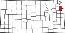 | |
| CDPs | ||
| Unincorporated communities | ||
| Townships |
| |
| Ghost town | ||
| Footnotes | ‡This populated place also has portions in an adjacent county or counties | |
Kansas City metropolitan area's cities and counties | ||
|---|---|---|
| Central city |  | |
| Largest cities (over 100,000 in 2000) | ||
| Medium-sized cities (10,000 to 100,000 in 2000) | ||
| Smaller Cities (between 5,000 and 9,900 in 2010) | ||
| Counties | ||