Longages
| Longages | |
|---|---|
|
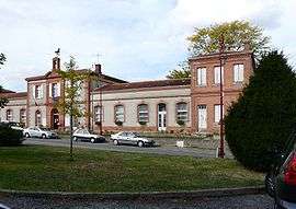
Town hall | |
 Longages | |
|
Location within Occitanie region  Longages | |
| Coordinates: 43°21′21″N 1°14′27″E / 43.3558°N 1.2408°ECoordinates: 43°21′21″N 1°14′27″E / 43.3558°N 1.2408°E | |
| Country | France |
| Region | Occitanie |
| Department | Haute-Garonne |
| Arrondissement | Muret |
| Canton | Carbonne |
| Intercommunality | Garonne-Louge |
| Government | |
| • Mayor (2008–2014) | Patrick Massarutto |
| Area1 | 21.42 km2 (8.27 sq mi) |
| Population (2008)2 | 2,552 |
| • Density | 120/km2 (310/sq mi) |
| Time zone | CET (UTC+1) |
| • Summer (DST) | CEST (UTC+2) |
| INSEE/Postal code | 31303 / 31410 |
| Elevation |
190–220 m (620–720 ft) (avg. 194 m or 636 ft) |
|
1 French Land Register data, which excludes lakes, ponds, glaciers > 1 km² (0.386 sq mi or 247 acres) and river estuaries. 2 Population without double counting: residents of multiple communes (e.g., students and military personnel) only counted once. | |
Longages is a commune in the Haute-Garonne department in southwestern France.
Population
| Historical population | ||
|---|---|---|
| Year | Pop. | ±% |
| 1962 | 908 | — |
| 1968 | 921 | +1.4% |
| 1975 | 1,101 | +19.5% |
| 1982 | 1,332 | +21.0% |
| 1990 | 1,691 | +27.0% |
| 1999 | 1,899 | +12.3% |
| 2008 | 2,552 | +34.4% |
Sights
The Château Sainte-Marie is a castle dating from the second half of the 16th century, modified and altered during the 19th century. It is listed as a historic site by the French Ministry of Culture.[1]
Transport
See also
References
- ↑ www.culture.gouv.fr, accessed 16 March 2008
| Wikimedia Commons has media related to Longages. |
This article is issued from Wikipedia - version of the 3/21/2014. The text is available under the Creative Commons Attribution/Share Alike but additional terms may apply for the media files.