Montlaur, Haute-Garonne
| Montlaur | ||
|---|---|---|
|
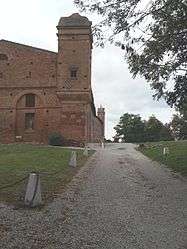
Chateau | ||
| ||
 Montlaur | ||
|
Location within Occitanie region  Montlaur | ||
| Coordinates: 43°29′21″N 1°34′19″E / 43.4892°N 1.5719°ECoordinates: 43°29′21″N 1°34′19″E / 43.4892°N 1.5719°E | ||
| Country | France | |
| Region | Occitanie | |
| Department | Haute-Garonne | |
| Arrondissement | Toulouse | |
| Canton | Montgiscard | |
| Intercommunality | Sicoval | |
| Government | ||
| • Mayor (2008–2014) | Pierre Muller | |
| Area1 | 9.61 km2 (3.71 sq mi) | |
| Population (2008)2 | 1,217 | |
| • Density | 130/km2 (330/sq mi) | |
| Time zone | CET (UTC+1) | |
| • Summer (DST) | CEST (UTC+2) | |
| INSEE/Postal code | 31384 / 31450 | |
| Elevation |
149–227 m (489–745 ft) (avg. 158 m or 518 ft) | |
|
1 French Land Register data, which excludes lakes, ponds, glaciers > 1 km² (0.386 sq mi or 247 acres) and river estuaries. 2 Population without double counting: residents of multiple communes (e.g., students and military personnel) only counted once. | ||
.svg.png)
Montlaur is a commune in the Haute-Garonne department of southwestern France.
Population
| Historical population | ||
|---|---|---|
| Year | Pop. | ±% |
| 1962 | 363 | — |
| 1968 | 403 | +11.0% |
| 1975 | 527 | +30.8% |
| 1982 | 646 | +22.6% |
| 1990 | 807 | +24.9% |
| 1999 | 889 | +10.2% |
| 2008 | 1,217 | +36.9% |
See also
References
| Wikimedia Commons has media related to Montlaur (Haute-Garonne). |
This article is issued from Wikipedia - version of the 4/1/2014. The text is available under the Creative Commons Attribution/Share Alike but additional terms may apply for the media files.