Saint-Élix-le-Château
| Saint-Élix-le-Château | ||
|---|---|---|
 | ||
| ||
 Saint-Élix-le-Château | ||
|
Location within Occitanie region  Saint-Élix-le-Château | ||
| Coordinates: 43°16′49″N 1°08′22″E / 43.2803°N 1.1394°ECoordinates: 43°16′49″N 1°08′22″E / 43.2803°N 1.1394°E | ||
| Country | France | |
| Region | Occitanie | |
| Department | Haute-Garonne | |
| Arrondissement | Muret | |
| Canton | Fousseret | |
| Intercommunality | Louge et du Touch | |
| Government | ||
| • Mayor (2008–2014) | Jean-Pierre Bonnemaison | |
| Area1 | 10.52 km2 (4.06 sq mi) | |
| Population (2008)2 | 691 | |
| • Density | 66/km2 (170/sq mi) | |
| Time zone | CET (UTC+1) | |
| • Summer (DST) | CEST (UTC+2) | |
| INSEE/Postal code | 31476 / 31430 | |
| Elevation |
222–244 m (728–801 ft) (avg. 225 m or 738 ft) | |
|
1 French Land Register data, which excludes lakes, ponds, glaciers > 1 km² (0.386 sq mi or 247 acres) and river estuaries. 2 Population without double counting: residents of multiple communes (e.g., students and military personnel) only counted once. | ||
.svg.png)
Saint-Élix-le-Château is a commune in the Haute-Garonne department in southwestern France.
Population
| Historical population | ||
|---|---|---|
| Year | Pop. | ±% |
| 1962 | 464 | — |
| 1968 | 499 | +7.5% |
| 1975 | 508 | +1.8% |
| 1982 | 524 | +3.1% |
| 1990 | 559 | +6.7% |
| 1999 | 542 | −3.0% |
| 2008 | 691 | +27.5% |
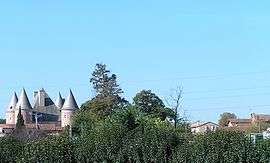
Sights
The Château de Saint-Élix-le-Château is a 16th-century castle which is listed as a historic site by the French Ministry of Culture.[1]
See also
References
- ↑ www.culture.gouv.fr, accessed 17 March 2008
| Wikimedia Commons has media related to Saint-Élix-le-Château. |
This article is issued from Wikipedia - version of the 4/3/2014. The text is available under the Creative Commons Attribution/Share Alike but additional terms may apply for the media files.