Antichan-de-Frontignes
| Antichan-de-Frontignes | |
|---|---|
 | |
 Antichan-de-Frontignes | |
|
Location within Occitanie region  Antichan-de-Frontignes | |
| Coordinates: 42°58′27″N 0°39′58″E / 42.9742°N 0.6661°ECoordinates: 42°58′27″N 0°39′58″E / 42.9742°N 0.6661°E | |
| Country | France |
| Region | Occitanie |
| Department | Haute-Garonne |
| Arrondissement | Saint-Gaudens |
| Canton | Barbazan |
| Intercommunality | Haut Cummings |
| Government | |
| • Mayor (2008–2020) | Bernard Dumail |
| Area1 | 4.27 km2 (1.65 sq mi) |
| Population (2010)2 | 82 |
| • Density | 19/km2 (50/sq mi) |
| Time zone | CET (UTC+1) |
| • Summer (DST) | CEST (UTC+2) |
| INSEE/Postal code | 31009 / 31510 |
| Elevation |
533–1,655 m (1,749–5,430 ft) (avg. 600 m or 2,000 ft) |
|
1 French Land Register data, which excludes lakes, ponds, glaciers > 1 km² (0.386 sq mi or 247 acres) and river estuaries. 2 Population without double counting: residents of multiple communes (e.g., students and military personnel) only counted once. | |
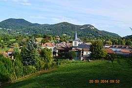
Antichan-de-Frontignes is a French commune in the Haute-Garonne department in the Occitanie region of south-western France.
The inhabitants of the commune are known as Antichanais or Antichanaises.[1]
Geography

Antichan-de-Frontignes is located at the foot of the Pyrenees in the Comminges region some 40 km east by south-east of Bagnères-de-Bigorre and 19 km south by south-west of Saint-Gaudens. Access to the commune is by the D618 road which branches from the D331 east of Ore and goes to the village then continues north-east by a roundabout route to Juzet-d'Izaut. There is also a local road going from the D618 north of the village to Saint-Pé-d'Ardet. Most of the commune is heavily forested however there is some farmland near the village.[2]
Neighbouring communes and villages[2]
 |
Lourde | Saint-Pé-d'Ardet | Moncaup | |
| Ore | |
Arguenos | ||
| ||||
| | ||||
| Frontignan-de-Comminges | Bezins-Garraux |
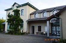
Administration
List of Successive Mayors[3]
| From | To | Name | Party | Position |
|---|---|---|---|---|
| 2001 | 2020 | Bernard Dumail |
(Not all data is known)
Demography
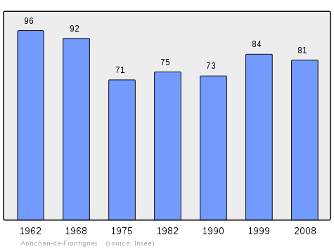
In 2010 the commune had 82 inhabitants. The evolution of the number of inhabitants is known from the population censuses conducted in the commune since 1793. From the 21st century, a census of communes with fewer than 10,000 inhabitants is held every five years, unlike larger communes that have a sample survey every year.[Note 1]
| 1793 | 1800 | 1806 | 1821 | 1831 | 1836 | 1841 | 1846 | 1851 |
|---|---|---|---|---|---|---|---|---|
| 241 | 250 | 242 | 288 | 349 | 336 | 335 | 330 | 333 |
| 1856 | 1861 | 1866 | 1872 | 1876 | 1881 | 1886 | 1891 | 1896 |
|---|---|---|---|---|---|---|---|---|
| 320 | 318 | 364 | 309 | 324 | 293 | 286 | 281 | 274 |
| 1901 | 1906 | 1911 | 1921 | 1926 | 1931 | 1936 | 1946 | 1954 |
|---|---|---|---|---|---|---|---|---|
| 258 | 282 | 262 | 241 | 238 | 244 | 240 | 112 | 103 |
| 1962 | 1968 | 1975 | 1982 | 1990 | 1999 | 2006 | 2010 | - |
|---|---|---|---|---|---|---|---|---|
| 96 | 92 | 71 | 75 | 73 | 84 | - | 82 | - |
Sources : Ldh/EHESS/Cassini until 1962, INSEE database from 1968 (population without double counting and municipal population from 2006)
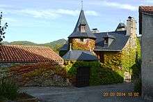
Sites and monuments

- The village is the point of departure for a hiking trail which crosses the Col des Ares 4.5 km from the village then continues to the summits of the Pic du Gar and the Saillant Peak.
- The Church of Notre-Dame of the Assumption
See also
External links
- Antichan-de-Frontignes on the old IGN website (French)
- Antichan-de-Frontignes on Lion1906
- Antichan-de-Frontignes on Google Maps
- Antichan-de-Frontignes on Géoportail, National Geographic Institute (IGN) website (French)
- Antichan-de-Frontignes on the 1750 Cassini Map
- Antichan-de-Frontignes on the INSEE website (French)
- INSEE (French)
Notes and references
Notes
- ↑ At the beginning of the 21st century, the methods of identification have been modified by Law No. 2002-276 of 27 February 2002, the so-called "law of local democracy" and in particular Title V "census operations" allows, after a transitional period running from 2004 to 2008, the annual publication of the legal population of the different French administrative districts. For communes with a population greater than 10,000 inhabitants, a sample survey is conducted annually, the entire territory of these communes is taken into account at the end of the period of five years. The first "legal population" after 1999 under this new law came into force on 1 January 2009 and was based on the census of 2006.
References
- ↑ Inhabitants of Haute-Garonne (French)
- 1 2 Google Maps
- ↑ List of Mayors of France (French)
| Wikimedia Commons has media related to Antichan-de-Frontignes. |