Longevilles-Mont-d'Or
| Longevilles-Mont-d'Or | |
|---|---|
 | |
 Longevilles-Mont-d'Or | |
|
Location within Bourgogne-Franche-Comté region  Longevilles-Mont-d'Or | |
| Coordinates: 46°45′16″N 6°19′02″E / 46.7544°N 6.3172°ECoordinates: 46°45′16″N 6°19′02″E / 46.7544°N 6.3172°E | |
| Country | France |
| Region | Bourgogne-Franche-Comté |
| Department | Doubs |
| Arrondissement | Pontarlier |
| Canton | Mouthe |
| Intercommunality | Mont d'Or et des Deux Lacs |
| Government | |
| • Mayor (2008–2014) | Claude Jacquemin-Verguet |
| Area1 | 13.25 km2 (5.12 sq mi) |
| Population (2012)2 | 445 |
| • Density | 34/km2 (87/sq mi) |
| Time zone | CET (UTC+1) |
| • Summer (DST) | CEST (UTC+2) |
| INSEE/Postal code | 25348 / 25370 |
| Elevation | 890–1,463 m (2,920–4,800 ft) |
|
1 French Land Register data, which excludes lakes, ponds, glaciers > 1 km² (0.386 sq mi or 247 acres) and river estuaries. 2 Population without double counting: residents of multiple communes (e.g., students and military personnel) only counted once. | |
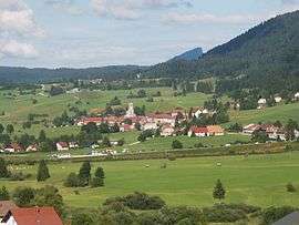
Longevilles-Mont-d'Or (unofficial also Les Longevilles) is a commune in the Doubs department in the Bourgogne-Franche-Comté region in eastern France.
Geography
The commune is located 10 km (6.2 mi) northeast of Mouthe. The village lies in a valley at the foot of the Mont d'Or, a massif that covers 9/10 of the territory of the commune.
The commune has a magnificent view of the Alps and the Swiss plain.
Population
| Historical population | ||
|---|---|---|
| Year | Pop. | ±% |
| 1962 | 215 | — |
| 1968 | 248 | +15.3% |
| 1975 | 253 | +2.0% |
| 1982 | 272 | +7.5% |
| 1990 | 323 | +18.8% |
| 1999 | 368 | +13.9% |
| 2008 | 405 | +10.1% |
| 2012 | 445 | +9.9% |
Economy
Winter sports and tourism dominate the economy of the commune. It is one of the six communes that have operated the Métabief Mont-d'Or ski resort since 1970.
See also
References
External links
| Wikimedia Commons has media related to Longevilles-Mont-d'Or. |
This article is issued from Wikipedia - version of the 10/29/2016. The text is available under the Creative Commons Attribution/Share Alike but additional terms may apply for the media files.