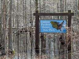
The Louisiana Purchase State Park commemorates the initial point from which land surveys of the U.S. territory acquired through the Louisiana Purchase (1803) were surveyed. It encompasses 37.5 acres (15.2 ha) of swampland, a landform which is regionally in decline due to agricultural development practices. In the center is a 6-foot (1.8 m) marker erected on the survey point by the L'Anguille Chapter, Daughters of the American Revolution, in 1926. The site was listed on the National Register of Historic Places (1972) and designated a National Historic Landmark (1993).[1]
Description
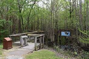
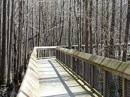
The historic state park is located at the eastern end of Arkansas Highway 362, southeast of Blackton, Arkansas, at the tripoint junction of Lee, Monroe, and Phillips counties. It is a 37.5-acre (15.2 ha) parcel of swampland, which is remarkably unchanged from the time when surveyors came here in 1815. This type of swampland is becoming increasingly rare because of the practice of draining and clearing them for agricultural use. The boardwalk, 950 feet (290 m) long, leads to the site of the marker, with occasional interpretive signs describing the ecology of the area and the significance of the monument.[2]
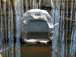
The Louisiana Purchase Survey Marker is 6 feet (1.8 m) in height and is about 4.5 feet (1.4 m) wide at the base. It typically stands in about 1 foot (0.30 m) of swamp water. The inscription reads: "This stone marks the base established November 10, 1815, from which the lands of the Louisiana Purchase were surveyed by United States engineers. The first survey from this point was made to satisfy the claims of the soldiers of the War of 1812 with land bounties".[2]
History
On April 30, 1803, negotiators for the United States and the First French Empire, signed the Louisiana Purchase agreement, by which the United States acquired 830,000 square miles (2,100,000 km2) of land west of the Mississippi River, doubling its size. President James Monroe ordered a survey of the territory in 1815, in order to permit the orderly award of land in the territory to military veterans of the War of 1812. Prospect K. Robbins and Joseph C. Brown were commissioned to identify a starting point for the survey work in what is now eastern Arkansas. The team led by Robbins traveled north from the mouth of the Arkansas River, while that of Brown traveled west from the mouth of the St. Francis River. On October 27, 1815, Robbins' party crossed the east-west line laid down by Brown's party at this point, formally establishing the Fifth Principal Meridian. The 55 miles (89 km) of land Robbins traversed is even today some of the most difficult terrain in the state to negotiate. Brown's party traversed 26 miles (42 km) of land alternately described as "good for farming" and containing "briers and thickets in abundance". Brown's party eventually surveyed as far west as present-day Little Rock, while Robbins continued north to the Missouri River. Two trees near the site were blazed to mark the meeting point of the two survey lines.[2]
Although survey work based on this point continued in subsequent years, covering most of Arkansas, Missouri, Minnesota, Iowa, and North and South Dakota, the initial point was forgotten. It was rediscovered in 1921 by surveyors working the line between Phillips and Lee Counties, who discovered the blazed trees. The Marianna, Arkansas chapter of the Daughters of the American Revolution began a campaign to memorialize the spot, culminating the placement of the stone marker and a dedication ceremony on October 27, 1926, the 111th anniversary of the point's establishment.[2]
One forgotten feature of the dedication ceremony was that four local landowners each gave deeds for 2 acres (0.81 ha) of land surrounding the point, which would have created an eight-acre park. The state designated the area a state park in 1961, but appropriated no funds for land purchases or development. The Arkansas Natural Heritage Commission, recognizing the swampland's natural significance, provided funds for purchasing the 37.5 acre which now make up the park, and now holds a conservation easement on the property to limit development.[2]
See also
Gallery
| Footpath leading to the boardwalk. |
| Boardwalk leading to the site. |
| Monument to the Louisiana Purchase Survey. |
|
References
External links
|
|---|
|
| Topics | |
|---|
|
| Lists by states | |
|---|
|
| Lists by insular areas | |
|---|
|
| Lists by associated states | |
|---|
|
| Other areas | |
|---|
|
-
 Portal Portal
-
 WikiProject WikiProject
|