Luna, Apayao
| Luna | ||
|---|---|---|
| Municipality | ||
| ||
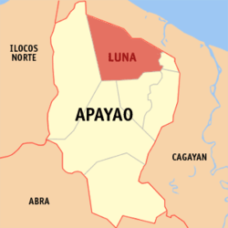
 Location in the province of Apayao | ||
.svg.png) Luna Location within the Philippines | ||
| Coordinates: 18°20′N 121°21′E / 18.33°N 121.35°ECoordinates: 18°20′N 121°21′E / 18.33°N 121.35°E | ||
| Country | Philippines | |
| Region | Cordillera Administrative Region (CAR) | |
| Province | Apayao | |
| District | Lone District | |
| Barangays | 22 (see Barangays) | |
| Government [1] | ||
| • Type | Sangguniang Bayan | |
| • Mayor | Josephine M. Bangsil | |
| Area[2] | ||
| • Total | 606.04 km2 (233.99 sq mi) | |
| Population (2015 census)[3] | ||
| • Total | 19,063 | |
| • Density | 31/km2 (81/sq mi) | |
| • Voter (2016)[4] | 10,250 | |
| Time zone | PST (UTC+8) | |
| ZIP code | 3813 | |
| IDD : area code | +63 (0)74 | |
| Income class | 2nd class | |
| PSGC | 148105000 | |
Luna, officially the Municipality of Luna (Filipino: Bayan ng Luna), is a municipality in the province of Apayao in the Cordillera Administrative Region (CAR) of the Philippines. The population was 19,063 at the 2015 census.[3] In the 2016 election, it had 10,250 registered voters.[4]
Its former name was Macatel, changed to Luna by the town's founding father, the Ilocano explorer Antonino Barroga from Dingras, Ilocos Norte.[5]
Geography
Luna is located at 18°20′N 121°21′E / 18.33°N 121.35°E.
According to the Philippine Statistics Authority, the municipality has a land area of 606.04 square kilometres (233.99 sq mi)[2] constituting 13.73% of the 4,413.35-square-kilometre- (1,704.00 sq mi) total area of Apayao.
Barangays
Luna is politically subdivided into 22 barangays.[6]
| PSGC | Barangay | Population | ±% p.a. | ||
|---|---|---|---|---|---|
| 2015[3] | 2010[7] | ||||
| 148105001 | Bacsay | 4.0% | 769 | 850 | −1.89% |
| 148105016 | Cagandungan | 3.4% | 647 | 618 | +0.88% |
| 148105017 | Calabigan | 1.9% | 368 | 532 | −6.78% |
| 148105018 | Cangisitan | 3.7% | 713 | 683 | +0.82% |
| 148105002 | Capagaypayan | 2.7% | 524 | 468 | +2.18% |
| 148105003 | Dagupan | 11.5% | 2,194 | 2,038 | +1.41% |
| 148105004 | Lappa | 3.8% | 727 | 667 | +1.65% |
| 148105019 | Luyon | 2.0% | 383 | 350 | +1.73% |
| 148105006 | Marag | 3.0% | 581 | 557 | +0.81% |
| 148105007 | Poblacion | 6.2% | 1,181 | 1,107 | +1.24% |
| 148105008 | Quirino | 7.1% | 1,353 | 1,228 | +1.86% |
| 148105009 | Salvacion | 2.0% | 372 | 395 | −1.14% |
| 148105010 | San Francisco | 4.6% | 880 | 840 | +0.89% |
| 148105020 | San Gregorio | 2.9% | 548 | 529 | +0.67% |
| 148105011 | San Isidro Norte | 4.0% | 759 | 750 | +0.23% |
| 148105021 | San Isidro Sur | 8.1% | 1,545 | 1,326 | +2.95% |
| 148105012 | San Sebastian | 2.3% | 442 | 355 | +4.26% |
| 148105013 | Santa Lina | 6.1% | 1,166 | 1,026 | +2.47% |
| 148105022 | Shalom | 3.4% | 652 | 666 | −0.40% |
| 148105014 | Tumog | 7.8% | 1,495 | 1,285 | +2.92% |
| 148105023 | Turod | 5.7% | 1,092 | 1,064 | +0.50% |
| 148105015 | Zumigui | 3.5% | 672 | 695 | −0.64% |
| Total | 19,063 | 18,029 | +1.07% | ||
Demographics
| Population census of Luna | |||||||||||||||||||||||||
|---|---|---|---|---|---|---|---|---|---|---|---|---|---|---|---|---|---|---|---|---|---|---|---|---|---|
|
| ||||||||||||||||||||||||
| Source: PSA[3][7][8] | |||||||||||||||||||||||||
In the 2015 census, Luna had a population of 19,063.[3] The population density was 31 inhabitants per square kilometre (80/sq mi).
In the 2016 election, it had 10,250 registered voters.[4]
References
- ↑ "Municipality". Quezon City, Philippines: Department of the Interior and Local Government. Retrieved 31 May 2013.
- 1 2 "Province: Apayao". PSGC Interactive. Makati City, Philippines: Philippine Statistics Authority. Retrieved 4 November 2016.
- 1 2 3 4 5 "CORDILLERA ADMINISTRATIVE REGION (CAR)". Census of Population (2015): Total Population by Province, City, Municipality and Barangay (Report). PSA. Retrieved 20 June 2016.
- 1 2 3 "2016 National and Local Elections Statistics". Commission on Elections. 2016.
- ↑ Belarde, Sonia; Ronald Ocampo (2010-02-05). "Municipal Background of Luna, The Show Window of Apayao". d' lunanians: The Official Site of the Municipality of Luna Apayao. Retrieved 2010-02-16.
- ↑ "Municipal: Luna, Apayao". PSA. Philippines: National Statistical Coordination Board. Retrieved 8 January 2016.
- 1 2 "CORDILLERA ADMINISTRATIVE REGION (CAR)". Census of Population and Housing (2010): Total Population by Province, City, Municipality and Barangay (Report). NSO. Retrieved 29 June 2016.
- ↑ "CORDILLERA ADMINISTRATIVE REGION (CAR)". Census of Population (1995, 2000 and 2007): Total Population by Province, City and Municipality (Report). NSO. Archived from the original on 24 June 2011.
External links
| Wikimedia Commons has media related to Luna, Apayao. |
 |
Claveria, Cagayan | Sanchez-Mira, Cagayan / Pamplona, Cagayan | Abulug, Cagayan |  |
| Calanasan | |
Santa Marcela | ||
| ||||
| | ||||
| Kabugao / Pudtol | Flora |

