Mahabalipuram
| Mamallapuram மாமல்லபுரம் Mahabalipuram | |
|---|---|
| town | |
|
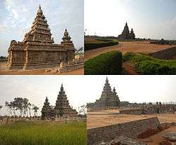
View of Shore Temple, Mahabalipuram / Mamallapuram | |
 Mamallapuram | |
| Coordinates: 12°36′59″N 80°11′58″E / 12.616454°N 80.199370°ECoordinates: 12°36′59″N 80°11′58″E / 12.616454°N 80.199370°E | |
| Country | India |
| State | Tamil Nadu |
| District | Kancheepuram |
| Elevation | 12 m (39 ft) |
| Population (2001) | |
| • Total | 12,049 |
| Languages | |
| • Official | Tamil |
| Time zone | IST (UTC+5:30) |
| PIN | 603104 |
| Telephone code | 91-44 |
(Tamil:மாமல்லபுரம்) Mamallapuram, also known as Mahabalipuram, is a town in Kancheepuram district in the Indian state of Tamil Nadu, around 60 km south of the city of Chennai. It is an ancient historic town and was a bustling seaport during the time of Periplus (1st century CE) and Ptolemy (140 CE), from where ancient Indian traders sailed to countries of South East Asia.
By the 7th century it was a port city of the South Indian dynasty of the Pallavas. It has a group of sanctuaries carved out of rock in the 7th and 8th centuries: rathas (temples in the form of chariots), mandapas (cave sanctuaries), giant open-air rock reliefs such as the famous Descent of the Ganges, and the Shore Temple, with thousands of sculptures to the glory of Shiva. The Group of Monuments at Mahabalipuram has been classified as a UNESCO World Heritage Site.
It has an average elevation of 12 metres (39 feet). The modern town of Mahabalipuram was established by the British Raj in 1827.[1]
Climate
Mahabalipuram has a tropical climate. The Köppen-Geiger climate classification is Aw. The average annual temperature is 28.4 °C. The temperatures are highest on average in May, at around 32.6 °C. In January, the average temperature is 24.3 °C, the lowest of the year. The average temperatures vary during the year by 8.3 °C. In a year, the average rainfall is 1219 mm. In winter, there is much less rainfall than in summer. The variation in the precipitation between the driest and wettest months is 309 mm.
| Climate data for Mahabalipuram | |||||||||||||
|---|---|---|---|---|---|---|---|---|---|---|---|---|---|
| Month | Jan | Feb | Mar | Apr | May | Jun | Jul | Aug | Sep | Oct | Nov | Dec | Year |
| Average high °C (°F) | 28.9 (84) |
30.4 (86.7) |
32.1 (89.8) |
34.4 (93.9) |
37.6 (99.7) |
37.4 (99.3) |
35.5 (95.9) |
34.9 (94.8) |
34.3 (93.7) |
32.0 (89.6) |
29.3 (84.7) |
28.5 (83.3) |
32.94 (91.28) |
| Daily mean °C (°F) | 24.3 (75.7) |
25.4 (77.7) |
27.2 (81) |
30.0 (86) |
32.6 (90.7) |
32.2 (90) |
30.8 (87.4) |
30.2 (86.4) |
29.7 (85.5) |
28.0 (82.4) |
25.8 (78.4) |
24.6 (76.3) |
28.4 (83.12) |
| Average low °C (°F) | 19.8 (67.6) |
20.4 (68.7) |
22.4 (72.3) |
25.6 (78.1) |
27.6 (81.7) |
27.1 (80.8) |
26.2 (79.2) |
25.5 (77.9) |
25.1 (77.2) |
24.1 (75.4) |
22.4 (72.3) |
20.8 (69.4) |
23.92 (75.05) |
| Average precipitation mm (inches) | 20 (0.79) |
6 (0.24) |
4 (0.16) |
11 (0.43) |
55 (2.17) |
62 (2.44) |
92 (3.62) |
124 (4.88) |
114 (4.49) |
240 (9.45) |
313 (12.32) |
178 (7.01) |
1,219 (48) |
| Average precipitation days | 2 | 1 | 1 | 2 | 3 | 4 | 6 | 8 | 8 | 13 | 15 | 10 | 71 |
| Source: [2] | |||||||||||||
History
Megalithic burial urn, cairn circles and jars with burials dating to the very dawn of the Christian era have been discovered near Mahabalipuram. The Sangam age poem Perumpāṇāṟṟuppaṭai relates the rule of King Thondaiman Ilam Thiraiyar at Kanchipuram of the Tondai Nadu port Nirppeyyaru which scholars identify with the present-day Mahabalipuram. Chinese coins and Roman coins of Theodosius I in the 4th century CE have been found at Mahabalipuram revealing the port as an active hub of global trade in the late classical period. Two Pallava coins bearing legends read as Srihari and Srinidhi have been found at Mahabalipuram. The Pallava kings ruled Mahabalipuram from Kanchipuram; the capital of the Pallava dynasty from the 3rd century to 9th century CE, and used the port to launch trade and diplomatic missions to Sri Lanka and Southeast Asia.
An 8th-century Tamil text written by Thirumangai Alvar described this place as Sea Mountain ‘where the ships rode at anchor bent to the point of breaking laden as they were with wealth, big trunked elephants and gems of nine varieties in heaps’. It is also known by several other names such as Mamallapattana and Mamallapuram. Another name by which Mahabalipuram has been known to mariners, at least since Marco Polo’s time is "Seven Pagodas" alluding to the Seven Pagodas of Mahabalipuram that stood on the shore, of which one, the Shore Temple, survives.[3]
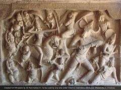
The temples of Mahabalipuram, portraying events described in the Mahabharata, were built largely during the reigns of Narasimhavarman and his successor Rajasimhavarman and show the movement from rock-cut architecture to structural building. The city of Mahabalipuram was largely developed by the Pallava king Narasimhavarman I in the 7th century AD.[3] The mandapa or pavilions and the rathas or shrines shaped as temple chariots are hewn from the granite rock face, while the famed Shore Temple, erected half a century later, is built from dressed stone. What makes Mahabalipuram so culturally resonant are the influences it absorbs and disseminates. The Shore Temple includes many reliefs, including one 100 ft. long and 45 ft. high, carved out of granite.[4]
All but one of the rathas from the first phase of Pallava architecture are modeled on the Buddhist viharas or monasteries and chaitya halls with several cells arranged around a courtyard.[5] Art historian Percy Brown, in fact, traces the possible roots of the Pallava Mandapa to the similar rock-cut caves of Ajanta Caves and Ellora Caves. Referring to Narasimhavarman's victory in AD 642 over the Chalukyan king Pulakesin II, Brown says the Pallava king may have brought the sculptors and artisans back to Kanchi and Mahabalipuram as 'spoils of war'.[6]
The fact that different shrines were dedicated to different deities is evidence of an increased sectarianism at the time of their construction. A rock relief on a sculpted cliff has an image of Shiva and a shrine dedicated to Vishnu, indicating the growing importance of these Sangam period deities and a weakening of the roles of Vedic gods such as Indra and Soma.[7]
According to local guides, the site's name changed during the centuries. The first name was Kațalmalai meaning "The land between the mountain and the sea" in Tamil. The second name was Mämalläpuram meaning "The land of the great wrestler" as the region was ruled by the Pallavan King Narsimhavarman during the 8th century who was known for his strength. The third name was and is still there is Mähäbalipuram meaning "The land of Mahabali". According to legends, he was the grandson of the devoted Prahlada.
 Mahabalipuram Shore Temple View from beach
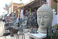 Mahabalipuram Art Sculpture Shops
Transport
MTC and TNSTC (Villupuram) Kanchipuram division buses are operating bus from Chennai, Chengalpattu, Kancheepuram, Thiruttani etc. Apart from TNSTC MTC operating buses to Mahabalipuram from various parts of the city with Deluxe and Air conditioned Deluxe buses
MTC bus Routes towards Mahabalipuram
| Route Number | Start | End | Via |
|---|---|---|---|
| 515 | Tambaram | Mahabalipuram | Vandalore Zoo, Kelambakkam, Thirupporur |
| 568 | Adyar | Mahabalipuram | Perugudi, Sholinganallur, Kelambakkam, Thirupporur |
| 568C | Koyambedu | Mahabalipuram | Vadapalani, Ashok nagar, Guindy, Madhya kailash, Perugudi, Sholinganallur, Kelambakkam, Thirupporur |
| 588 | Adyar | Mahabalipuram | Thiruvanmiyur, VGP, MGM, Kovalam, Thiruvedanthai, Vadanemmeli, Devanery |
| 588B | Broadway | Mahabalipuram | Annasquare,AIR, Santhome, AMS, Adyar, Thiruvanmiyur, VGP, MGM, Kovalam, Thiruvedanthai, Vadanemmeli, Devanery
THIS ROUTE IS AVAILABLE ONLY ON SUNDAY AND GOVERNMENT HOLIDAYS |
| 588C | Koyambedu | Mahabalipuram | Vadapalani, Ashok nagar, Guindy, Madhya kailash, Thiruvanmiyur, VGP, MGM, Kovalam, Thiruvedanthai, Vadanemmeli, Devanery |
| 589 | Velachery | Mahabalipuram | SRP Tools, Thiruvanmiyur, VGP, MGM, Kovalam, Thiruvedanthai, Vadanemmeli, Devanery |
| 599 | Mahabalipuram | T Nagar | Saidapet, Adyar, Thiruvanmiyur, VGP, MGM, Kovalam, Thiruvedanthai, Vadanemmeli, Devanery |
Landmarks
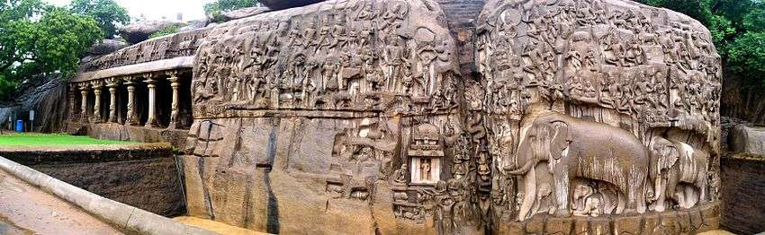
The monuments are mostly rock-cut and monolithic, and constitute the early stages of Dravidian architecture where in Buddhist elements of design are prominently visible. They are constituted by cave temples, monolithic rathas (chariots), sculpted reliefs and structural temples. The pillars are of the Dravidian order. The sculptures are excellent examples of Pallava art. They are located in the side of the cliffs near India's Bay of Bengal.
It is believed by some that this area served as a school for young sculptors. The different sculptures, some half finished, may have been examples of different styles of architecture, probably demonstrated by instructors and practiced on by young students. This can be seen in the Pancha Rathas where each Ratha is sculpted in a different style. These five Rathas were all carved out of a single piece of granite in situ.[4] While excavating Khajuraho, Alex Evans, a stonemason and sculptor, recreated a stone sculpture made out of sandstone, which is softer than granite, under 4 feet that took about 60 days to carve. The carving at Mahabalipuram must have required hundreds of highly skilled sculptors.[8]
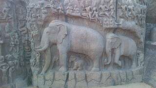
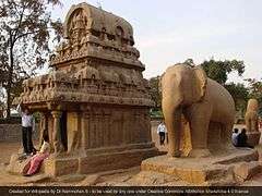
In 2004 the Indian Ocean Tsunami washed away tons of coastal sand exposing structures including a granite lion and an elephant relief. [9]
Some important structures include:
- Thirukadalmallai, the temple dedicated to Lord Vishnu. It was also built by Pallava King in order to safeguard the sculptures from the ocean.
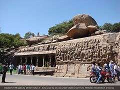
- Descent of the Ganges or Bagiratha's Penance – a giant open-air rock relief
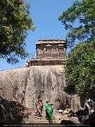
- Varaha Cave Temple – a small rock-cut temple dating back to the 7th century.
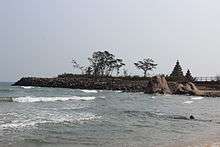
- The Shore Temple – a structural temple along the Bay of Bengal with the entrance from the western side away from the sea. Recent excavations have revealed new structures here.
- Pancha Rathas (Five Chariots) – five monolithic pyramidal structures named after the Pandavas (Arjuna, Bhima, Yudhishtra, Nakula and Sahadeva) and Draupadi. An interesting aspect of the rathas is that, despite their sizes they are not assembled – each of these is carved from one single large piece of stone.
- Light House, built in 1894.
Demography
As of 2001 India census,[10] Mahabalipuram had a population of 12,345.[11] Males constitute 52% of the population and females 48%. Mahabalipuram has an average literacy rate of 74%, higher than the national average of 59.5%: male literacy is 82%, and female literacy is 66%. In Mahabalipuram, 12% of the population is under 6 years of age.
Gallery
 Mahabalipuram elephant statue
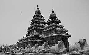 Shore temple, view from the north face
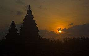 Sunrise at Shore Temple
 Namrta Rai performing Kathak Recital at Mamallapuram Dance Festival 2015

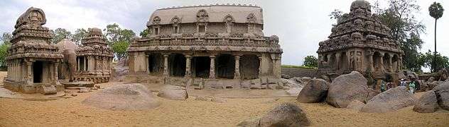 Panoramic view of sculptures
 Five Rathas in Mahabalipuram diagonal view
 Mahabalipuram Shore Temples
 Shore Temple Mahabalipuram
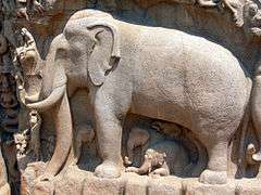 Elephant and other creatures carved in granite at Mahabalipuram.
 Cave Temple at Mahabalipuram.
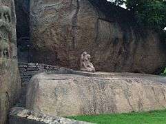 Monkey picking lice off other monkey at Mahabalipuram.
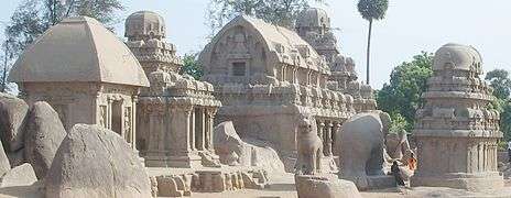 Pancha Rathas at Mahabalipuram.
 Light House
 Shore Temple at Mahabalipuram.
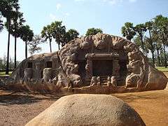 Tiger Cave
 Submerged Temple at Mahabalipuram
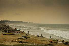 Mahabalipuram Beach
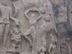 Arjuna's Penance
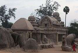 Mahabalipuram Temple at Dusk
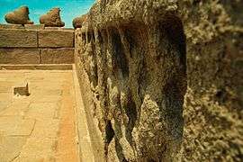 Stone Carvings at Mahabalipuram
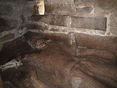 Mahabalipuram seashore temple - Recumbent Vishnu
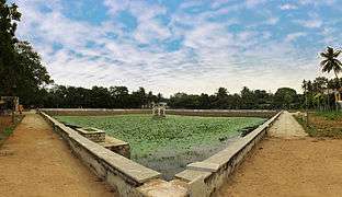 Tank at Mahabalipuram
 Shore Temple at Mahabalipuram
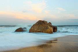 Mahabalipuram Beach
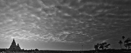 Panorama of Shore Temple at Mahabalipuram
 Mahabalipuram Beach Panorama
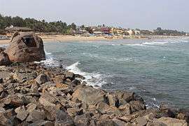 Mahabalipuram Beach Shore
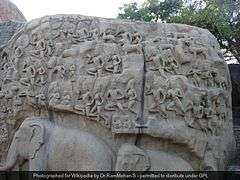 mahablipuram world heritage site, sculpture
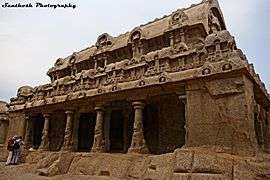 Cave Temple of mahabalipuram
 Shore Temple of mahabalipuram
 Carvings of mahabalipuram
 Backside View of mahabalipuram
 Lion Statue
 Temples of mahabalipuram
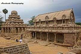 Temples of mahabalipuram
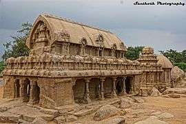 Temples of mahabalipuram
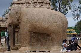 Single Stone Elephant Carving of mahabalipuram
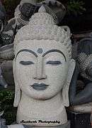 Budha Statue of mahabalipuram
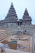 Temples of mahabalipuram
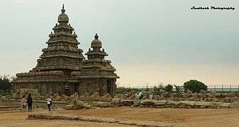 Temples of mahabalipuram
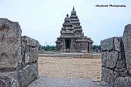 Temples of mahabalipuram
 Temples of mahabalipuram
See also
Literature
- Lukas Hartmann: Mahabalipuram oder Als Schweizer in Indien. Ein Reisetagebuch. Arche, Zürich, ISBN 978-3-716-01764-7.
References
- ↑ Encyclopædia Britannica, 15th Edition (1982), Vol. VI, p. 497
- ↑ "Climate: Mahabalipuram". climate-data.org.
- 1 2 Sundaresh, A. S. Gaur, Sila Tripati, K. H. Vora (10 May 2004). "Underwater investigations off Mahabalipuram" (PDF). Current Science. 86 (9).
- 1 2 Ancient Discoveries: Lost Cities of the Deep History Channel
- ↑ "Mahabalipuram Tamilnadu". Tamilnadu.com. 29 September 2012.
- ↑ http://www.pilgrimage-india.com/south-india-pilgrimage/mahabalipuram.html
- ↑ Doniger, Wendy, The Hindus: An Alternative History, Oxford University Press, 2010, ISBN 978-0-19-959334-7 (pbk)
- ↑ "Lost Worlds of the Kama Sutra" History channel
- ↑ "Tsunami waves exposed remnants of lost city". New Scientist Magazine. 2005-02-26. Retrieved 2013-12-27.
- ↑ "Census of India 2001: Data from the 2001 Census, including cities, villages and towns (Provisional)". Census Commission of India. Archived from the original on 2004-06-16. Retrieved 2008-11-01.
- ↑ "Census of towns in Tamil Nadu" (PDF). Census of India. Retrieved 2012-06-10.
- Sources
- Ayyar, P. V. Jagadisa (1991), South Indian shrines: illustrated, New Delhi: Asian Educational Services, ISBN 81-206-0151-3.
- Bradnock, Roma; Bradnock, Robert (2009), Footprint India, USA: Patrick Dawson, ISBN 1-904777-00-7.
- Pippa de Bruyn, Keith Bain, David Allardice (2010). Frommer's India. Frommer's. p. 350. ISBN 0-470-55610-2, ISBN 978-0-470-55610-8.
- Hurd, James (2010), Temples of Tamilnad, USA: Xilbris Corporation, ISBN 978-1-4134-3843-7.
- Singh, Sarina (2009), South India (Lonely Planet Regional Guide) (5th ed.), Lonely Planet, ISBN 978-1-74179-155-6
External links
| Wikimedia Commons has media related to Mahabalipuram. |
-
 Mamallapuram travel guide from Wikivoyage
 - Things to do in Mahabalipuram
- Mahabalipuram
- Article on Mahabalipuram
- Mahabalipuram must watch