Manhattanville, Manhattan
Coordinates: 40°48′58″N 73°57′22″W / 40.81611°N 73.95611°W
Manhattanville (also known as West Harlem or West Central Harlem)[1] is a neighborhood in the New York City borough of Manhattan bordered on the north and south by West 134th Street and West 122nd Street, respectively; on the west by Morningside Park and on the east by Adam Clayton Powell Jr. Boulevard.[1] Other sources show the neighborhood bordered on the north and south by West 135th Street and West 123rd Street, respectively; on the west by the Hudson River and on the east by the campus of City College.[2]
Throughout the 19th century, Manhattanville bustled around a wharf active with ferry and daily river conveyances. It was the first station on the Hudson River Railroad running north from the city, and the hub of daily stage coach, omnibus and streetcar lines. Situated near the famous Bloomingdale Road, its hotels, houses of entertainment and post office made it an alluring destination of suburban retreat from the city, yet its direct proximity to the Hudson River also made it an invaluable industrial entry point for construction materials and other freight bound for upper Manhattan. With the construction of road and railway viaducts over the valley in which the town sat, Manhattanville, increasingly absorbed into the growing city, became a marginalized industrial area.
In the early 2000s, the neighborhood became the site of a major planned expansion of Columbia University, which has campuses in Morningside Heights to the south and Washington Heights to the north.
History
Colonial period and establishment
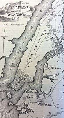
Manhattanville sits in a valley formerly called Moertje David's Vly ("Mother David's Valley"; in Dutch, Vly is short for vallei, or "valley") during the Dutch Colonial period and as Harlem Cove during the English Colonial period. During the American Revolutionary War, the valley was also known as the Hollow Way, where the main action of the Battle of Harlem Heights began under the command of General George Washington. During the War of 1812 the valley's southern ridges figured as the site of the Manhattanville Pass, whose defense fortifications and breastworks included Fort Laight and Blockhouse No. 4,[4] which became the sites of Morningside Gardens Houses and PS 36, respectively.
In 1806, the village of Manhattanville was established in this valley around the crossroads of Bloomingdale Road and Manhattan Street, now roughly Broadway and 125th Street. The village's original streets were laid out by Jacob Schieffelin and other wealthy merchants, mostly Quakers, who had country seats in the area. The town thrived as a result of the development of Manhattan Street from the Hudson River, whose convenient access also became a crucial catalyst in the growth of the older village of Harlem to the southeast on the Harlem River. Situated at approximately the same latitude, Harlem and Manhattanville flourished together throughout the 19th century as the two most prominent villages in upper Manhattan.

.jpg)
Manhattanville's early population was a diverse and eclectic mix of intermarried American patriots and British loyalists; at least one prominent former African slave trader (this seems to be a reference to Michael Hogan, whose wife was of mixed British and Indian ancestry, born in Bombay); slave owners and enslaved African-Americans; Quaker anti-slavery activists and free black abolitionists; tradesmen, poor laborers and wealthy industrialists.[5] Many were affiliated with the same institutions, principally the historic New York City landmarked St. Mary's Protestant Episcopal Church, organized in 1823, which was the first Episcopal church to dissolve pew rent in 1831, and the Manhattanville Free School (established in 1827, later Public School No. 43) still at their original sites. Manhattanville's most prominent resident was industrialist Daniel F. Tiemann (1805-1899), owner of the D.F. Tiemann & Company Color Works, who was also Mayor of New York City from 1858 to 1859. The Tiemann laboratory and factory which was originally located on 23rd Street and Fourth Avenue in Gramercy, near Madison Square Park, relocated uptown to Manhattanville in 1832, in part due to an underground spring of running water at the new uptown location, which is today the site of 560 Riverside Drive.[6]
Immigration and urbanization
Later noteworthy population changes occurred around the mid-19th century following the opening of the Hudson River Railroad in 1850, with an influx of mostly Catholic Irish (who established the Church of the Annunciation in 1854) and Germans (who established St. Joseph's Roman Catholic Church in 1860). After the American Civil War, the Jewish immigrant population that began to distinguish itself in Harlem gradually filtered into the western blocks of Manhattanville (and established Chevra Talmud Torah Anshei Marovi, also known as Old Broadway Synagogue, in 1911). Other prominent 19th-century Manhattanville institutions included the Academy of Convent of the Sacred Heart (later called Manhattanville College) and Manhattan College.
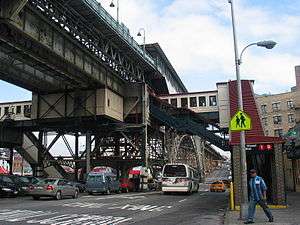
In 1904, the opening of the Interborough Rapid Transit Company (IRT)'s new Broadway – Seventh Avenue Line, now part of the 1 train on the New York City Subway, galvanized Manhattanville's radical transformation from rural exburb to an extension of the growing city, with the elevated railway providing rapid transit downtown. Cuban, Dominican and Puerto Rican immigrants moved into the area during the 20th century. By the 1970s, the southern part of Manhattanville (up to about 125th Street) was being filled by Columbia and Barnard College students, staff and faculty, as the university continued to expand.
West 125th Street has experienced a general economic upturn since the end of the 1990s. Many of the buildings below 125th Street have converted to cooperative ownership as the area experiences continuing gentrification and increasing demand for housing. In collaboration with the community, the city has developed a plan for the 125th Street corridor focusing on reinforcing and building upon its strengths as an arts and cultural corridor.[7]
21st century
University expansions
Manhattanville is the site of a planned major expansion of Columbia University. The university purchased several square blocks of the neighborhood between 125th[8] and 133rd Streets on the south and north and between Broadway and 12th Avenue on the east side of Broadway from 131 to 134, west of the housing projects.. According to the plan, the physical plant of those blocks will be partly demolished to construct a new campus, secondary school and park land, designed by Italian architect Renzo Piano. Local residents feared the impact of the further gentrification from this expansion in addition to the possible, and controversial, use of eminent domain. In 2006, Columbia built a new School of Social Work on Amsterdam Avenue at 122nd Street. In June 2007, the New York City Department of City Planning certified that Columbia's application for the rezoning is complete. This action launched the public review and comment period under the city's Uniform Land Use Review Procedure, which lasted until the end of 2007.[9] In December of the same year, the New York City Council voted to approve Columbia’s proposed rezoning of the site.[10]
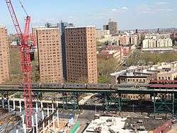
Other colleges have been building dormitories in the area as well. To the north, the 589-student dorm The Towers[11] finished construction in June 2006 as an extension of the City College of New York on St. Nicholas Terrace. This is the first time that City College has housed students on the campus. Occupancy began in August 2006.[11] To the south, near 122nd Street, the Manhattan School of Music also built a dormitory around 2003. In 2006, Jewish Theological Seminary of America opened a smaller dormitory on 122nd Street between Broadway and Amsterdam Avenue.
In August 2009, at 135th Street and Convent Avenue, City College completed the construction of a new 135,000-square-foot (12,500 m2) School of Architecture and Urban Design building (The Bernard and Anne Spitzer School of Architecture, named after the New York real estate developer and philanthropist, Bernard Spitzer and his wife).[12][13] Based on a pre-existing 1950s structure, the old Cohen Library on South Campus, this redesign and reconstruction by Rafael Viñoly Architects is intended to add a modern aesthetic to the eclectic architectural mix in the area.
West Harlem Piers
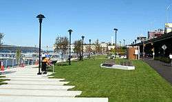
After a groundbreaking ceremony in November 2005, construction of the West Harlem Piers Waterfront park began in April 2006.[14] The park includes a fishing pier, a kayak launch, sculptures, and water taxi landings, stretches from 125th St to 132nd Street, partly on land formerly used as a parking lot. It closed a gap in the Manhattan Waterfront Greenway that runs along the western side of Manhattan Island and will later connect up the Hudson River. The park opened in early October 2008, delayed through the summer by the discovery that fencing designed to prevent users from falling into the river did not meet specifications.[15] The area that surrounds the park and piers is at times called ViVa (Viaduct Valley).
Arts and nightlife
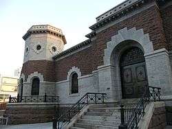
Artistic revitalization continued in October 2006 when The Gatehouse Theater opened as an additional facility of Aaron Davis Hall,[16] a venue specializing in dance. It was built by rehabilitating a former 19th century Croton Aqueduct building at 135th St and Convent Avenue. Upon completion, both Aaron Davis Hall and the Gatehouse Theater evolved to share a common name, Harlem Stage.
Demographics
Based on data from the 2010 United States Census, the population of Manhattanville was 22,950, a decrease of 1,822 (7.4%) from the 24,772 counted in 2000. Covering an area of 248.49 acres (100.56 ha), the neighborhood had a population density of 92.4 inhabitants per acre (59,100/sq mi; 22,800/km2).[17]
The racial makeup of the neighborhood was 7.5% (1,710) White, 25.8% (5,918) African American, 0.3% (77) Native American, 2.2% (496) Asian, 0.0% (5) Pacific Islander, 0.3% (76) from other races, and 1.1% (255) from two or more races. Hispanic or Latino of any race were 62.8% (14,413) of the population.[18]
Sites of interest
Historic religious institutions
Four of Manhattanville’s houses of worship are among the most historically distinguished in all of Harlem, none of which are located in the area slated for the expansion of Columbia University:
- St. Mary’s Protestant Episcopal Church on West 126th Street (formerly Lawrence Street), organized in 1823, was the only church in the district (indeed, in the entire Harlem territory with the exception of the Dutch Reformed Church on the East Side) in the second quarter of the nineteenth century. Its present stone building, built in 1908-1909 by T. E. Blake and the architectural firm of Carrere & Hastings, is the church’s second structure on same site of the church’s original wood frame structure, built in 1824 and consecrated in 1826. In 1831, St. Marys was the first church in the Episcopal Diocese to abolish pew rentals. The marble seal inlaid into the church porch of "Jacob Schieffelin's Vault", the burial vault in which Jacob Schieffelin and his wife Hannah Lawrence Schieffelin (who were the church's land donors as well as Manhattanville's principal founders) are interred, is clearly visible to passersby. Today St. Mary's is the oldest congregation in continuous service on its original site in the entire Harlem area. In 1998, the complex of church, its adjacent frame parish house (circa 1851) and brick school building (1890) were officially designated a New York City landmark.
- Church of the Annunciation (Roman Catholic) on Covent Avenue and West 131st Street, founded in 1854, was the first Catholic church to be built on Manhattan’s west side above 2nd Street, and ministered particularly to the Irish Catholic laborers on the Hudson River Railroad. The Christian Brothers established the church building adjacent to Manhattan College, at 131st Street and the Bloomingdale Road (Old Broadway). The Brothers subsequently sold the adjoining church and rectory sites to John Hughes, the first Catholic Archbishop of New York. The present stone building, built in 1906-1907 by the architectural firm of Lynch & Orchard, is the church’s second structure, to which the congregation moved from two blocks east in 1907.
- Church of St. Joseph of the Holy Family, founded in 1860 as the Church of the Holy Family by Manhattanville’s German Catholic community at the northwest corner of 125th Street and Morningside Avenue. A 100th anniversary souvenir history in 1960 noted: "While the construction of the church was going on . . . on May 30, of the year 1861 was celebrated what was probably the first public Corpus Christi procession in New York City." Manhattanville historian John J. Hopper mentions this church in his circa 1920 reminiscences as "the German Catholic Church at Ninth Avenue, which my father [Isaac A. Hopper] built" during his boyhood on Manhattan Street from 1853 to 1865. (Although the AIA guide attributes the church’s architecture to the Herter Brothers in 1889, the incorrect building date was probably confused that of the St. Joseph R.C. School building around the corner at 168 Morningside Avenue). David Dunlap cites this church in his book, "Glory in Gotham: Manhattan’s Houses of Worship," as the oldest church [building] in Harlem.
- Old Broadway Synagogue, an Orthodox Jewish synagogue incorporated in 1911 under the name Chevra Talmud Torah Anshei Marovi, was built on Old Broadway (a rare vestige on Manhattan island of the Bloomingdale Road) by the architectural firm of Meisner & Uffner in 1923. The congregation formed from the mostly Ashkenazic Jewish population of Russian and Polish immigrants to New York during the 1880s who had made their way up to Central Harlem, then migrated to blocks west. The building is listed individually on the National Register of Historic Places.
Other sites of interest
Aside from Grant's Tomb, Riverside Church and the Manhattan School of Music at the southwestern corner, the principal landmarks in Manhattanville are the IRT Broadway Line and Riverside Drive Viaducts. Within the neighborhood is Manhattanville Houses, a 1,272-unit development of the New York City Housing Authority, which opened in 1961. Designed in the international style by noted Swiss-born architect William Lescaze, the development was initially created to house middle income residents.
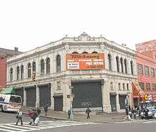
The neighborhood also contains the landmarked neo-Renaissance Claremont Theatre where Thomas Edison once shot a short film in 1915 featuring the building's entrance,[19][20][21] the Manhattanville Bus Depot, St. Mary's Church, and the Fairway Supermarket, whose broad selections attract distant customers.
In Riverside Park, north of Grant's Tomb, is the site of the former Claremont Inn, a riverside respite and hotel for the affluent back in its heyday. It was originally built around 1775 as a private mansion and estate. By the end of the 19th century it was bought by the city of New York and leased to a hotelier. There was also a place to rent bicycles at the inn. It had a serious fire in the 1940s which caused its demise. A plan was in the making for a reuse of the inn and restaurant and grounds when yet a final fire caused its closing in 1951. A stone plaque marks where it once stood.[22][23][24]
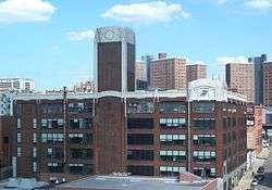
During the 1920s, on 131st Street between Broadway and Twelfth Avenue, a Studebaker automobile factory plant made luxury cars. The building was sold in the Great Depression in the 1930s to Borden to be used as a dairy plant. In the 21st century it is used by Columbia University and has a Studebaker Cafe in it.[25]
References
Notes
- 1 2 Garb, Maggie (June 21, 1998). "If You're Thinking of Living In/West Central Harlem; Abandonment Down, Refurbishment Up". The New York Times.
The area [West Central Harlem], a slice of 19th-century brownstones, prewar walk-ups and small elevator buildings bounded by 122nd and 134th Streets, Morningside Park and Adam Clayton Powell Jr. Boulevard, appears on city maps as the western part of Central Harlem. Some residents call it Manhattanville, the name of the post office on 125th Street near the boulevard.
- ↑ Pesce, Nicole Lyn (October 17, 2010). "A Guide to West Harlem's Manhattanville Neighborhood". New York Daily News.
Whether you call it West Harlem or Manhattanville, the upper-upper West Side is enjoying a second renaissance.
- ↑ Lossing, Benson (1868). The Pictorial Field-Book of the War of 1812. Harper & Brothers, Publishers. p. 972.
- ↑
- ↑ Eric K. Washington, Manhattanville, Introduction
- ↑ Baptista, Robert J., "D.F. Tiemann & Co. Color Works, Manhattanville, New York City", Colorants Industry History, July 7, 2009
- ↑ New York City Economic Development Corporation (NYCEDC) 125th Street Project
- ↑ Because of the dogleg shape of 125th Street on the west side, 125th Street and 129th Street merge, and so only four or five blocks are involved in the tract.
- ↑ "Welcome" (Press release). Columbia University / Manhattanville in West Harlem. n.d. Retrieved 2014-01-01.
- ↑ "[Untitled]" (Press release). Columbia University / Manhattanville in West Harlem. December 19, 2007. Retrieved 2014-01-01.
- 1 2 "About The Towers". City College of New York. n.d. Retrieved 2014-01-01.
- ↑ From the architects' website
- ↑ "The Bernard and Anne Spitzer School of Architecture. New York, New York. Rafael Viñoly Architects", Architectural Record
- ↑ From the University's Harlem Piers page
- ↑ Daniel Amsallag, Construction Snag Delays Pier Opening, Columbia Daily Spectator, September 15, 2008
- ↑ From the Aaron Davis Hall website
- ↑ Table PL-P5 NTA: Total Population and Persons Per Acre - New York City Neighborhood Tabulation Areas*, 2010, Population Division - New York City Department of City Planning, February 2012. Accessed June 16, 2016.
- ↑ Table PL-P3A NTA: Total Population by Mutually Exclusive Race and Hispanic Origin - New York City Neighborhood Tabulation Areas*, 2010, Population Division - New York City Department of City Planning, March 29, 2011. Accessed June 14, 2016.
- ↑ Grace, Matthew, "New Landmark Designation: Claremont Theater", The New York Observer, June 7, 2006 (archived 2006)
- ↑ "Claremont Theatre: NY 1915 Thomas Edison", Library of Congress, film archives. (MPG version)
- ↑ "Claremont Theater Building, 3320-3338 Broadway (aka 536-540 West 135th Street), Manhattan", New York City Landmarks Preservation Commission, June 6, 2006, Designation List 375 LP-2198
- ↑ "Remember: The Claremont Inn", Harlem Bespoke
- ↑ "Remember: Claremont Bicycles", Harlem Bespoke
- ↑ "Riverside Park: Claremont Inn tablet", New York City Department of Parks and Recreation. Claremont Inn Tablet in Claremont Playground; Incised plaque set in pavement; Deer Isle granite; Dedicated: 1952
- ↑ "Studebaker Building", Harlem Bespoke
Further reading
- Walsh, Kevin, Forgotten New York: Views of a Lost Metropolis, HarperCollins, 2006
- Walsh, Kevin, ed. "Manhattanville". Forgotten-NY.com. Archived from the original on February 6, 2010.
- Washington, Eric K., Manhattanville: Old Heart of West Harlem, Arcadia Publishing, Images of America series, 2002, ISBN 0-7385-0986-8
- CB9M 197-a Plan
- CB9M West Harlem Piers Master Plan
External links
- Community Board No. 9 - Manhattan
- CB9M Chairman's Blog
- Manhattanville: Old Heart of West Harlem - Eric K. Washington website
- Coalition to Preserve Community website
- West Harlem Local Development corporation
- West Harlem Business Group website