Marambio Base
| Marambio Base Base Marambio | |
|---|---|
| Antarctic base | |
|
Airfield control tower at Marambio | |
| Nickname(s): Spanish: Puerta de Entrada a la Antártida ("Antarctica's Entrance Door") | |
 Marambio Base Location within Antarctica | |
| Coordinates: 64°14′27.65″S 56°37′36.31″W / 64.2410139°S 56.6267528°WCoordinates: 64°14′27.65″S 56°37′36.31″W / 64.2410139°S 56.6267528°W | |
| Country |
|
| Province | Tierra del Fuego, Antarctica, and South Atlantic Islands Province |
| Department | Antártida Argentina |
| Region | Graham Land, Antarctic Peninsula |
| Location | Marambio Island |
| Founded | October 29, 1969 (1969–70 austral summer season) |
| Named for | Gustavo Argentino Marambio |
| Government | |
| • Type | Directorate |
| • Body | Dirección Nacional del Antártico |
| • Operator | Instituto Antártico Argentino |
| Area[1] | |
| • Indoors | 2 ha (5 acres) |
| Elevation | 196 m (643 ft) |
| Population [1][2] |
|
| Time zone | ART (UTC-3) |
| Type | All year-round |
| Period | Annual |
| Status | Active and operational |
| Facilities |
|
Marambio Base (Spanish: Base Marambio) is a permanent, all year-round Argentine Antarctic base named after Vice-Commodore Gustavo Argentino Marambio, an Antarctic aviation pioneer. It is located in Marambio Island, Graham Land, Antarctic Peninsula, some 100 km (60 mi) from the coastal civilian village of Esperanza.
At the time of its construction it was the first airfield in Antarctica and is still one of the most frequently used ones due to its suitability for wheeled landing, for which it is called "Antarctica's Entrance Door" (Spanish: Puerta de Entrada a la Antártida).[3] It is also Argentina's most important base in the continent.[3]
As of 2014 Marambio is one of 13 research bases in Antarctica operated by Argentina.[4]
History
The increased Antarctic activity that Argentina developed since 1940 created the need for an aviation runway operable throughout the year for wheeled units. The flight of Vice-Commodore Mario Luis Olezza to the South Pole, the newly built United States McMurdo Station and the frequent operations launched from the Matienzo Base showed the need to secure better transport and communications in the sector.[1]
The Argentine Air Force set about to find a suitable spot to mount an airport. On 25 November 1968, two helicopters operating from the icebreaker ARA General San Martín descended on the Marambio Island as part of such survey. Their report favoring the place was decisive: it lacked large obstacles that could trouble aircraft maneuvering, and its long plateau was virtually free of ice.[1]
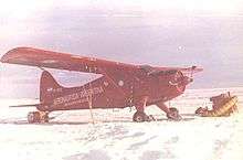
On 30 August 1969, an Air Force team led by Vice-Commodore Olezza occupied the island, carrying with them the elements needed for the construction of the projected landing track. When initially opened, the 05/23-oriented runway had a length of 300 m (980 ft). It was the first one in the continent.[5] The task took three months of work and culminated when a de Havilland Canada DHC-2 Beaver, set with conventional wheels, took off from Matienzo Base and landed on the new airport. Before the end of October the runway had already reached 800 m (2,600 ft).[6]
The base was founded on 29 October 1969. That day a Fokker F-27 Friendship of the Argentine Air Force manned by Vice-Commodore Erwin Roberto Kern, left Rio Gallegos and landed directly in Marambio Base, carrying on board civil and military authorities.[3] It was the first aircraft taking off in another continent and landing in Antarctica using conventional landing gear:[1] Antarctica was no longer an isolated place; from that day onwards all domestic and foreign Antarctic bases got interconnected with the rest of the world throughout the year. It was the most important Antarctic event in the decade.[1]
By April 1970 the runway had reached 1,200 m (3,900 ft) long and 40 m (130 ft) wide.[5] On 11 April 1970 the Argentine Air Force began landing their C-130 Hercules on Antarctica when the TC-61 commanded by Commodore Arturo Athos Gandolfi landed in Marambio, starting a long-standing and uninterrupted tradition of air-supplying the Antarctic Argentine bases from the mainland.[6] and the Fokker F-28 Fellowship presidential aircraft T-01 Patagonia was the first jet to land in Antarctica when it touched down at Marambio on 28 July 1973, 13:28 h.[5]
Description
As of 2014 Marambio has 27 buildings with a total covered area exceeding 20,000 m2 (220,000 sq ft; 2.0 ha).[1][3] It can host a permanent crew of 45 men and a large complement of scientific personnel, totaling about 200 people,[1] although on average it is populated with 55 members in winter and 150 in summer.[2] Some of the facilities are: main, dining and recreation halls; emergency house with 28-bed capacity; personnel accommodation buildings; aircraft parking platform; flight deck; airline passenger terminal; flight ground support equipment; library; mail office; gym; chapel; laundry; kitchen; two freezing chambers; snow melter; satellite dish for television and internet; radio communications station; towing and personnel carrier vehicles (including tractors, trucks and forklifts); road maintenance tools and vehicles (several snow dozers, tracked loaders and graders); mechanical, carpentry, blacksmithing, turning, plumbing and electricity workshops; laboratory with substations for APT (Automatic Picture Transmission) satellite imagery receiver, ozone and uv light measurement, sounding balloon setup and launching, a MBI International Meteorological Center, and others; several warehouses and deposits; fuel storage array; potable water and sewerage network; incinerator and waste disposal module, and firefighting system.[1][2] The base also has CATV and public and internal mobile phone service.[1] The 45 m2 (480 sq ft) medical suite is attended by one doctor and three paramedics, and has three beds and x-ray, dentistry, coronary care and telemedicine facilities. Over 492,000 l (108,000 imp gal; 130,000 US gal) of Antarctic gasoil are used every year for transportation, and to feed the 1,000 kW main power plant with its three Caterpillar generators. The base also has a sewage treatment plant.[1] Most buildings are connected together by risen metal footpaths to isolate them from snow and ice.[1]
On 2010 the Argentine company CITEDEF designed and installed a wind generator on the base.
Airport
| Marambio | |||||||||||
|---|---|---|---|---|---|---|---|---|---|---|---|
 Aerial view of Marambio's runway | |||||||||||
| IATA: MBO – ICAO: SAWB | |||||||||||
| Summary | |||||||||||
| Airport type | landing track | ||||||||||
| Serves | Marambio Base | ||||||||||
| Location | Antarctica | ||||||||||
| Runways | |||||||||||
| |||||||||||
The flight control tower is 12 m (39 ft) high, and as of 2014 it is equipped with low-visibility weather navigation and landing assistance systems like VOR, DME, NDB[5] and radio beacon. Its runway is lined with strobe lights. Supplies are taken to Marambio Base during the whole year, to be later distributed to other Argentine bases nearby (except for Belgrano II). There are over 100 intercontinental flights every year.[5] The parking platform lets in heavy cargo planes like the Hercules C-130 with access to fuel and concurrent services. There is also an hangar for the Argentine Air Force de Havilland Canada DHC-6 Twin Otter that routinely operates from the base along the two Bell 212s that are deployed during the summer campaigns to support scientific activities and link to other Argentine bases.[3]
These facilities make Marambio the main air-support node for most bases in Argentine Antarctica, all the year-round, providing medical evacuation; search and rescue; personnel, cargo and mail transfer and release, both for local and foreign stations.[1]
Communications
The base is connected to the Argentine mainland and the world through a satellite downlink station with telephone, fax, TV and internet. They also have a DirecTV dish which provides their service to the whole base. Argentine mobile telephone company Claro and Spanish Movistar have an antenna for local coverage. Within the base and between bases, radio is the most used mean of communication, mainly through HF, Vox/Data, aeronautic VHF-AM and UHF-FM.
Internet access is provided by Speedy Argentina, allowing the personnel in the base to be permanently connected to net services. Wireless LAN and Wi-Fi cover the entire complex, becoming one of the southernmost spots in the world with a wireless network. Telephone service is provided by Telefónica de Argentina at low national rates.
In September 2006, a GSM mobile phone network was also added to the base, provided by the Argentine mobile operator CTI Móvil (now Claro).[8]
Scientific activities
Scientific research at Marambio is planned and executed by specialized departments, usually during the summer campaigns:
- Earth Sciences carries out paleontology, stratigraphy, sedimentology, petrography, cryology,[1] glaciology[9][10] and geodesy.[11][12]
- Atmospheric Sciences research include cosmic ray and ionospheric observations,[13] and stratospheric ozone monitoring.[14] The LAMBI Ozone Laboratory, managed by the Atmospheric Sciences station, started in 1994 to obtain ozone records by absorption. It is a joint program with the INTA (Spanish National Institute for Aerospace Technology)[1]
- Geophysics analyzes the composition, structure and mobility of the Antarctic lithosphere by seismic, magnetic, magnetotelluric and gravimetric surveys. It researches on tectonic dynamics in order to define its configuration from the Cretaceous to the present. It also conducts paleoclimatic and paleoenvironmental studies to determine relevant trends during the late Cenozoic.[1]
- Dynamics and Chemistry of Ice investigates changes during the last decade in selected glaciers on the Ross and Vega islands. It also examines significant changes in the Larsen Ice Shelf and provides essential information on the distribution of Antarctic icebergs along the tracks of vessels operating in the Antarctic.[1]
- Human Impact researches environmental processes in relation to possible disturbances caused by human activities over the terrestrial ecosystem dynamics in the area of Marambio. The program develops guidelines for environmental management and monitoring.[1]
In addition Marambio is home to various ongoing scientific projects:
- The Museoantar historical archeology program undergoes recovery, preservation and restoration of the refuges built by the 1901–04 Swedish Antarctic Expedition on Snow Hill Island.[1]
- In 2011, during the "Mars in Marambio" mission, NASA scientists arrived at the base to test a new space suit designed for future exploration of Mars.[15]
- In 2013 the Finnish Meteorological Institute in co-operation with its Argentine counterpart and with the Argentine Air Force started a new continuous atmospheric measurement program in Marambio. Observations cover greenhouse gases (mostly CH4 and CO2) while investigating the physical, chemical and optical properties of aerosol particles and incoming and outgoing UV radiation. This scientific project made Marambio the most comprehensive atmospheric measurement station in the Antarctic continent.[16]
- The base has been chosen for the location of balloon launches of the French project Estrateole to study the ozone layer.[1]

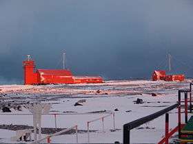
Marambio under daily routine duties, date unknown 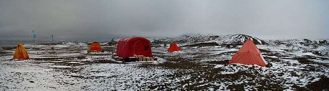
Scientific camp, 2009 austral autumn 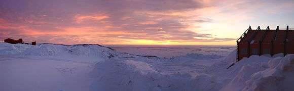
Panoramic photo of Marambio Base at dawn, 2009 austral autumn
Climate
In spite of its relatively low latitude, Marambio Base is situated in an ice cap climate, albeit much less severe than in Antarctica's interior.
Nonetheless, the climate is severe with mean temperatures that rarely rise above 0 °C (32 °F) and the presence of strong winds.[17] The strong winds produce a wind chill that makes the temperatures feel colder.[17] In particular, gusts up to 220 km/h (140 mph) can occur during the winter months.[17]
Mean monthly temperatures range from −15.1 °C (4.8 °F) in June to −1.7 °C (28.9 °F) in December.[17] During summer, the average high is above freezing while the average low is −4.2 °C (24.4 °F).[17] However, temperatures can reach up to 15 °C (59.0 °F) or fall below −15 °C (5.0 °F) during summer.[17] In winter, the average high is −11 °C (12 °F) while the average low is −19 °C (−2 °F).[17] Occasionally, temperatures can reach above freezing during winter.[17] This occurs when warm air from the northeast (characterized by high cloud cover and fog) or from the northwest moves towards the peninsula.[17] As the warm air crosses the mountains in the peninsula, it warms as it descend, leading to warm and dry conditions in a manner similar to a Zonda wind.[17] Its highest recorded temperature is 17.4 °C (63.3 °F) on 23 March 2015.[18]
Fog frequently occurs in the base.[17] December and January are the foggiest months, averaging 16 to 19 days with fog while June to September are the least, averaging 9 to 11 days.[17] The base is characterized by high cloud cover throughout the year in the form of Stratus clouds.[17] Summer is the cloudiest season, averaging 24 cloudy days while winters are the least cloudiest, averaging 10 to 11 cloudy days.[17]
| Climate data for Marambio (1971–1990, extremes 1971–present) | |||||||||||||
|---|---|---|---|---|---|---|---|---|---|---|---|---|---|
| Month | Jan | Feb | Mar | Apr | May | Jun | Jul | Aug | Sep | Oct | Nov | Dec | Year |
| Record high °C (°F) | 15.2 (59.4) |
12.6 (54.7) |
17.4 (63.3) |
12.3 (54.1) |
15.4 (59.7) |
8.4 (47.1) |
10.8 (51.4) |
8.5 (47.3) |
9.8 (49.6) |
11.7 (53.1) |
13.8 (56.8) |
16.5 (61.7) |
17.4 (63.3) |
| Average high °C (°F) | 0.1 (32.2) |
−0.6 (30.9) |
−3.5 (25.7) |
−7.9 (17.8) |
−10.0 (14) |
−10.9 (12.4) |
−10.9 (12.4) |
−10.8 (12.6) |
−6.9 (19.6) |
−3.0 (26.6) |
−1.4 (29.5) |
0.5 (32.9) |
−5.4 (22.3) |
| Daily mean °C (°F) | −1.9 (28.6) |
−3.0 (26.6) |
−6.9 (19.6) |
−12.1 (10.2) |
−13.8 (7.2) |
−15.1 (4.8) |
−14.9 (5.2) |
−14.5 (5.9) |
−11.1 (12) |
−7.1 (19.2) |
−4.3 (24.3) |
−1.7 (28.9) |
−8.9 (16) |
| Average low °C (°F) | −3.6 (25.5) |
−5.2 (22.6) |
−9.9 (14.2) |
−15.4 (4.3) |
−17.2 (1) |
−18.7 (−1.7) |
−18.4 (−1.1) |
−18.8 (−1.8) |
−15.0 (5) |
−10.6 (12.9) |
−7.0 (19.4) |
−3.7 (25.3) |
−12.0 (10.4) |
| Record low °C (°F) | −9.5 (14.9) |
−15.6 (3.9) |
−24.6 (−12.3) |
−31.5 (−24.7) |
−34.5 (−30.1) |
−37.6 (−35.7) |
−36.8 (−34.2) |
−38.3 (−36.9) |
−34.0 (−29.2) |
−26.8 (−16.2) |
−21.3 (−6.3) |
−11.2 (11.8) |
−38.3 (−36.9) |
| Average precipitation mm (inches) | 56 (2.2) |
48 (1.89) |
75 (2.95) |
59 (2.32) |
54 (2.13) |
47 (1.85) |
54 (2.13) |
72 (2.83) |
62 (2.44) |
56 (2.2) |
65 (2.56) |
59 (2.32) |
707 (27.82) |
| Average snowy days | 16 | 13 | 13 | 12 | 9 | 8 | 8 | 7 | 8 | 10 | 13 | 15 | 132 |
| Source #1: Servicio Meteorologico Nacional,[19] Weatherbase (precipitation)[20] | |||||||||||||
| Source #2: Meteo Climat (record highs and lows excluding March record high)[21] | |||||||||||||
See also
References
- 1 2 3 4 5 6 7 8 9 10 11 12 13 14 15 16 17 18 19 20 "Base Antártica Marambio" (in Spanish). Fundación Marambio. Archived from the original on 20 January 2013.
- 1 2 3 "Intercambio de información – Información Permanente". Dirección Nacional del Antártico. Archived from the original on 17 May 2013.
- 1 2 3 4 5 "Misión y Organización – Organismos y Unidades – Base Marambio" (in Spanish). Argentine Air Force. Archived from the original on 3 December 2013.
- ↑ "Argentine Antarctic Stations". Dirección Nacional del Antártico. Archived from the original on 20 June 2013.
- 1 2 3 4 5 "Marambio Station / Seymour Island". French-Polar-Team. Archived from the original on 7 March 2014.
- 1 2 "Primer aterrizaje de un Hércules C-130 (TC-61) en Marambio" (in Spanish). Fundación Marambio. Archived from the original on 29 May 2013.
- ↑ "Base Marambio". World Aero Data. Archived from the original on 6 April 2013.
- ↑ "CTI, Nokia Deploy GSM Technology in Antarctic Base". Cellular News. 7 September 2008. Archived from the original on 19 June 2014.
- ↑ "Exploring the Lifecycle of a Drifting Antarctic Iceberg". National Snow and Ice Data Center.
- ↑ Scambos, Ted. "Investigating Iceberg Evolution During Drift and Break-Up: A Proxy for Climate-Related Changes in Antarctic Ice Shelves". National Snow and Ice Data Center.
- ↑ "Guidelines for Antarctic GPS monumentation - Edition 2". Scientific Committee on Antarctic Research.
- ↑ Zakrajsek A. F., Peretti, A. (1997). "Geodetic Monumentation in Antarctic Permafrost, Marambio (Seymour) Island".
- ↑ "Encyclopedia Astronautica – Marambio". Astronautix. Archived from the original on 31 December 2013.
Sounding rocket launch location known to have been used for 7 launches from 1975 to 1982, reaching up to 400 kilometers altitude
- ↑ "Studies on Atmospheric Ozone from Belgrano and Marambio Stations in Antarctica, and Ushuaia, Argentina". Global Change Master Directory. NASA.
- ↑ Henao, Luis Andrés (21 March 2011). "NASA tests Mars space suit in Argentine Antarctica". Reuters.
- ↑ "The Finnish Meteorological Institute measures aerosols and greenhouse gases all year round in Antarctica". Finnish Meteorological Institute. 11 March 2013. Archived from the original on 19 October 2013.
- 1 2 3 4 5 6 7 8 9 10 11 12 13 14 "Base Marambio" (in Spanish). Servicio Meteorológico Nacional. Retrieved 13 November 2016.
- ↑ http://www.ogimet.com/cgi-bin/gsynres?ind=89055&decoded=yes&ndays=2&ano=2015&mes=03&day=24&hora=00
- ↑ "Servicios Climáticos – Información de Turismo – Base Marambio – Datos estadísticos (1971–1990)" (in Spanish). National Meteorological Service of Argentina. Retrieved 4 February 2013.
- ↑ "Weatherbase: Historical Weather for Vicecomodoro Marambio Base, Antarctica". Weatherbase. Retrieved 4 February 2013.
- ↑ "Station Marambio" (in French). Meteo Climat. Retrieved November 8, 2015.
External links
| Wikimedia Commons has media related to Marambio Base. |
- Fuerza Aerea Argentina – Base Marambio (Spanish)
- Fundaciòn Marambio – Base Marambio (Spanish)
- Dirección Nacional del Antártico (Spanish)
| General | .svg.png) | |
|---|---|---|
| Geographic regions | ||
| Waterways | ||
| Famous explorers | ||