May 1981 tornado outbreak
 Path of the Binger, Oklahoma Tornado on May 22, 1981 | |
| Type | Tornado outbreak |
|---|---|
| Duration | May 22–23, 1981 |
| Tornadoes confirmed | 43 confirmed |
| Max rating1 | F4 tornado |
| Duration of tornado outbreak2 | ~26 hours |
| Damage | $32.8 million (1981 USD) |
| Casualties | 12 injuries |
| Areas affected | Central United States |
|
1Most severe tornado damage; see Fujita scale 2Time from first tornado to last tornado | |
The May 1981 Tornado Outbreak was a tornado outbreak that occurred on May 22 in western and Central Oklahoma and on May 23 from eastern and central Oklahoma to central Iowa. 43 tornadoes were reported during the two-day outbreak, of which 14 were recorded as strong or violent (F2 or greater on the Fujita Scale). The outbreak claimed no fatalities and there were only 12 injuries from a tornado that touched down near Clinton, Oklahoma causing significant damage. The tornado outbreak overall left $32.8 million (1981 USD) in damage.[1][2]
Storm history
On the morning of May 22, 1981, winds moving in from the south brought moist air across Texas and into western Oklahoma and dry line formed across the Texas panhandle. In addition, the interaction between a layer of warm air aloft and the return flow of moist air led to widespread low clouds across the state of Oklahoma. Later that day, the low clouds broke as predicted by forecasters as the dry line moved east into western Oklahoma. However, the clearing was limited to a relatively narrow zone ahead of the dry line. Despite this, daytime heating allowed thunderstorms to form by mid-afternoon.[1]
Cordell Oklahoma tornado
The first tornado formed northwest of Cordell, Oklahoma at 4:17 pm (CDT). The tornado damaged a mobile home and several barns as it moved northeast over a six-mile path. The tornado was photographed 5 times by a storm chaser team during a project conducted by the National Severe Storms Laboratory and Mississippi State University. The tornado turned out to be a significant F2. Luckily, no one was hurt. Many storm chasers sometimes nicknamed the tornado the "Wizard of Oz" tornado because of its unusual ropey shape. In fact, the tornado had no curve at the top as it was nearing its decaying stage.
Binger tornado
A second thunderstorm formed south of the thunderstorm that produced the Cordell tornado. The second thunderstorm moved northeast, causing some concern among officials and forecasters as the storm was heading directly towards Oklahoma City. The second thunderstorm produced 6-12 tornadoes across a wide area stretching from Fort Cobb Reservoir to Union City. The thunderstorm later encountered cooler, less unstable air and dissipated near Oklahoma City.[1]

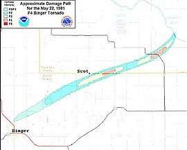
One of the group of the tornadoes, the Binger Tornado which touched down near Binger at 6:45 pm (CDT). At the time of formation, it was a weak F1 Tornado until it reached a point of 3.5 miles, west-southwest of the Scott community. At that point it strengthened and reach F4 status 1 mile east of the neighborhood. The tornado maintained F4 strength as it crossed Highway 37 until it dissipated near the Canadian River. Damage from the tornado was severe as it destroyed an old uninhabited house outside of Scott. Two other houses were also destroyed but their walls remained intact. A mile east, the tornado ripped the roof, walls and carport off another house while two more houses were completely destroyed. In addition the tornado uprooted or damaged several trees and flipped over automobiles and farm equipment during its 16-mile duration.[3]
Near Highway 37, the tornado blew away several storage tanks at an Amoco oil storage facility. One of the tanks, which was out of operation because of a lightning strike, was found 1500 ft south of its original location. The other two tanks blown away by the tornado were never found. A 1/2 mile away, the tornado destroyed a farmhouse and a barn and wrecked a pickup truck. Because the path of the Binger Tornado was mostly over unpopulated areas and due to early warnings and observations, there were no fatalities or injuries.[3]
Other tornadoes
After the Binger tornado dissipated, a complex of severe thunderstorms regenerated further west across west-central Oklahoma near Foss Reservoir. The thunderstorms produced at least five tornadoes, one of which affected the area around Clinton, Oklahoma causing 12 injuries. In Alfalfa, Oklahoma, two tornadoes were reported, one which did F2 Damage.[1][4] Thunderstorms along and east of a line from Oklahoma City, Kansas City and Omaha, Nebraska produced 29 tornadoes on May 23 across Oklahoma, Missouri, Kansas and Iowa. The same system travelled northwest and produced an F3 tornado that struck Bowl Bay, McCurdy Island on May 25.
Tornado table
| F0 | F1 | F2 | F3 | F4 | F5 | Total |
|---|---|---|---|---|---|---|
| 15 | 14 | 11 | 2 | 1 | 0 | 43 |
Confirmed tornadoes
May 22, 1981 event
| F# | Location | County | Time (UTC) | Path length | Damage | |
|---|---|---|---|---|---|---|
| Oklahoma | ||||||
| F2 | N of New Cordell | Washita | 2217 | 6.9 miles (11 km) |
See section above | |
| F1 | E of Lake Valley | Washita | 2325 | 1 miles (1.6 km) |
||
| F2 | E of Cowden | Washita, Caddo | 0007 | 5 miles (8 km) |
Tornado damaged a house, outbuildings, trees, power poles, and wheat crop. | |
| F1 | SW of Arapaho | Custer | 0015 | 0.1 miles (0.16 km) |
Tornado struck several farms, damaging houses, outbuildings, farm equipment, and crops. | |
| F0 | W of Albert | Caddo | 0029 | 0.3 miles (0.5 km) |
||
| F2 | N of Mountain View to W of Eakla | Kiowa, Washita, Caddo | 0030 | 15.4 miles (24.6 km) |
A dozen homes were torn apart. Outbuildings, farm equipment, and crops were damaged as well. | |
| F2 | N of Stafford | Washita, Custer | 0030 | 10.4 miles (16.6 km) |
Barns were destroyed and two homes were damaged in Arapaho. A gas station was completely destroyed. | |
| F4 | NE of Binger | Caddo, Canadian | 0049 | 16.7 miles (26.7 km) |
See section above | |
| F1 | NW of Clinton | Custer | 0100 | 0.1 miles (0.16 km) |
||
| F1 | NW of Union City | Canadian | 0132 | 2 miles (3.2 km) |
||
| F3 | N of Clinton | Custer | 0155 | 10.3 miles (16.5 km) |
A few homes were badly damaged in Clinton. A convenience store was destroyed near Arapaho. | |
| F2 | E of Greenfield | Blaine | 0340 | unknown | Several farms were damaged. A barn on one farm was destroyed, with five-foot-deep concrete moorings ripped out. | |
| F1 | NE of Cleveland | Osage | 0700 | 0.1 miles (0.16 km) |
||
| Kansas | ||||||
| F0 | N of Beverly | Lincoln | 2315 | 0.5 miles (0.8 km) |
||
| Minnesota | ||||||
| F0 | Moorhead | Clay | 2317 | 0.1 miles (0.16 km) |
||
| Source: Tornado History Project - May 22, 1981 Storm Data Grazulis (1981) | ||||||
May 23, 1981 event
| F# | Location | County | Time (UTC) | Path length | Damage | |
|---|---|---|---|---|---|---|
| Iowa | ||||||
| F0 | S of Clarinda | Page | 2032 | 0.1 miles (0.16 km) |
||
| F0 | SW of Grant | Montgomery | 2032 | 0.1 miles (0.16 km) |
||
| F0 | W of Canby | Adair | 2115 | 0.1 miles (0.16 km) |
||
| F0 | NE of Anita | Cass | 2130 | 0.1 miles (0.16 km) |
||
| F0 | E of Canby | Adair | 2202 | 0.1 miles (0.16 km) |
||
| F0 | N of Arbor Hill | Adair | 2215 | 0.1 miles (0.16 km) |
||
| F0 | S of Dexter | Madison | 2236 | 0.1 miles (0.16 km) |
||
| F2 | SW of Beaconsfield | Ringgold | 2300 | 15.9 miles (25.4 km) |
Several farm homes and outbuildings were damaged. A combine was thrown across a road and wrapped around a tree. | |
| F1 | SE of Earlham | Madison | 2328 | 0.1 miles (0.16 km) |
||
| F2 | W of Osage | Mitchell | 2355 | 3.8 miles (6.1 km) |
Five farms sustained damage. Three barns, three machine sheds, a trailer, and a garage were destroyed. | |
| Oklahoma | ||||||
| F1 | E of Bristow | Creek | 2100 | 0.1 miles (0.16 km) |
||
| F1 | NW of Hoover | Garvin | 2200 | 2 miles (3.2 km) |
||
| F0 | NW of Lenapah | Noata | 2230 | 0.1 miles (0.16 km) |
||
| F1 | Sulphur area | Murray | 2305 | 0.1 miles (0.16 km) |
||
| F1 | SW of McLoud | Pottawatomie | 2325 | 0.1 miles (0.16 km) |
||
| F1 | SE of Aydelotte | Pottawatomie | 2330 | 0.1 miles (0.16 km) |
||
| F2 | NE of Copan | Washington, Nowata, Montgomery (KS) | 2330 | 15.2 miles (24.3 km) |
Two frame homes and three trailers were destroyed along the track. | |
| F2 | NW of Elliot | Nowata | 2335 | 4.5 miles (7.2 km) |
||
| F3 | Durant area | Bryan | 0058 | 9.7 miles (15.5 km) |
Moved along the west edge of Durant. Significant damage to resort property at Lake Texoma. Caused $5,000,00 in damage. | |
| F1 | SW of Sasakwa | Bryan | 0100 | 0.1 miles (0.16 km) |
||
| F2 | E of Colcord | Delaware | 0118 | unknown | ||
| Kansas | ||||||
| F0 | NW of Wallula | Leavenworth | 2115 | 2 miles (3.2 km) |
||
| F2 | W of Scipio | Anderson | 2115 | 1.5 miles (2.4 km) |
A trailer was completely destroyed. A farm struck by the tornado sustained heavy damage to the house, outbuildings, and farm equipment. | |
| F1 | S of Centerville | Linn | 2215 | 2 miles (3.2 km) |
||
| F0 | E of Coffeyville | Montgomery | 2325 | 0.5 miles (0.8 km) |
||
| F1 | SW of Valeda | Montgomery | 2340 | 0.5 miles (0.8 km) |
||
| Missouri | ||||||
| F0 | W of Ferrelview | Platte | 2153 | 3.8 miles (6.1 km) |
||
| F0 | N of Nevada | Vernon | 2355 | 0.5 miles (0.8 km) |
||
| Source: Tornado History Project - May 23, 1981 Storm Data Grazulis (1981) | ||||||
See also
References
- 1 2 3 4 Mike Branick (2006). "A Look Back on the Tornado Outbreak in Oklahoma on 22 May 1981--The Binger Tornado" (PDF). NOAA. Retrieved 2006-10-27.
- ↑ NCDC (1981). "Oklahoma event details". NOAA. Retrieved 2006-10-27.
- 1 2 James R. McDonald; H. Scott Norville & Timothy P. Marshall (2006). "DAMAGE SURVEY OF THE BINGER, OKLAHOMA TORNADO OF MAY 22, 1981". National Severe Storms Laboratory. Retrieved 2006-10-27.
- ↑ NSSL (2006). "Public Domain Tornado Images". Retrieved 2006-10-27.