March 2–3, 2012 tornado outbreak
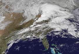 GOES 13 image of the storm system on March 2 | |
| Type | Tornado outbreak |
|---|---|
| Duration | March 2–3, 2012 |
| Tornadoes confirmed |
70 confirmed (Record for a continuous outbreak in March) |
| Max rating1 | EF4 tornado |
| Duration of tornado outbreak2 | 2 days |
| Damage | $3.1 billion[1] |
| Casualties | 41 fatalities + 2 indirect; many injured |
|
1Most severe tornado damage; see Enhanced Fujita scale 2Time from first tornado to last tornado | |
On March 2 and 3, 2012, a deadly tornado outbreak occurred over a large section of the Southern United States into the Ohio Valley region. The storms resulted in 41 tornado-related fatalities, 22 of which occurred in Kentucky.[2] Tornado-related deaths also occurred in Alabama, Indiana, and Ohio. The outbreak was the second deadliest in early March for the U.S. since official records began in 1950; only the 1966 Candlestick Park tornado had a higher death toll for a tornadic system in early March.[3]
Meteorological synopsis
February 2012 was more active than normal in terms of the number of tornadoes, with a total of 50 confirmed. While the first three weeks of the month were unusually quiet, the pattern changed abruptly by a major tornado outbreak, which struck the region less than 72 hours prior to this storm, killing 15 people, including 8 in Harrisburg, Illinois alone, the result of an EF4 tornado. A moderate risk of severe weather was issued for March 2 a day in advance for a large area from near Tuscaloosa, Alabama to Dayton, Ohio as an intense storm system tracked across the region in a very high shear environment.[4] Intense tornadoes were possible.[4] On the morning of March 2, it was upgraded and a high risk of severe weather was issued for Middle Tennessee and central Kentucky, later extended into Central and Southern Indiana and southern Ohio.[5][6] The Storm Prediction Center mentioned the potential for significant tornadoes.[6] Multiple PDS tornado watches were issued shortly thereafter.[7][8]
The outbreak began fairly early in the morning, with an initial round of storms and tornadoes associated with the incoming warm front attached to a rapidly deepening low pressure area over the central Great Lakes.[9] The initial round of storms allowed for a strong warm air mass to enter the region, with temperatures rising to near-record levels for early March and instability combining with extreme wind shear, resulting in a highly volatile air mass.[6] As a result, a second, much larger broken line of discrete supercells developed and followed the Ohio River, with additional storms developing farther south. During the afternoon, those cells tracked eastward across the Ohio Valley, passing north of Louisville, Kentucky and south of Cincinnati, Ohio with devastating results.[8]
| Outbreak death toll | |||
| State/Province | Total | County | County total |
|---|---|---|---|
| Alabama | 1 | Tallapoosa | 1 |
| Indiana | 13 | Clark | 1 |
| Jefferson | 4 | ||
| Ripley | 3 | ||
| Scott | 1 | ||
| Washington | 5 | ||
| Kentucky | 22 | Johnson | 2 |
| Kenton | 4 | ||
| Laurel | 6 | ||
| Lawrence | 2 | ||
| Menifee | 2 | ||
| Morgan | 6 | ||
| Ohio | 4 | Adams | 1 |
| Clermont | 3 | ||
| Totals | 41 | ||
| Only tornado-related deaths are included | |||

As isolated activity developed farther south, intense supercells also formed in central Kentucky in the late afternoon hours and tracked east into the Eastern Mountain Coal Fields region before weakening as they reached West Virginia later that evening. That area had the highest wind shear – with helicity values as high as 800 m2/s2 (despite lower instability) and that allowed the storms to spin violently, resulting in severe damage in several communities.[10][11]
The next day, on March 3, the cold front continued to push eastwards toward the United States East Coast, although the most severe activity took place near the Georgia-Florida state border.[12] A slight risk of severe weather was issued for a small area extending from Cape Hatteras to the Mississippi Delta.[13] A mesoscale convective system in South Carolina was responsible for hail reports in the area, although the threat for tornadoes was reduced with lower instability levels.[14] Most tornado activity for the day was associated with an upper-level system in Florida, also causing damaging wind gusts.[15] On March 4, most of the cold front responsible for the outbreak had already moved into the Atlantic Ocean with only a small portion of thunderstorms extending into Florida. A slight risk was issued for a section of Florida.[16] Some scattered activity lingered around the East Coast for the duration of the day, but no additional tornadoes were reported.[17]
Tornadoes
| EF0 | EF1 | EF2 | EF3 | EF4 | EF5 | Total |
|---|---|---|---|---|---|---|
| 27 | 18 | 14 | 9 | 2 | 0 | 70 |
March 2 event
| List of reported tornadoes – Friday, March 2, 2012 | ||||||
|---|---|---|---|---|---|---|
| | | | | | | |
| Alabama | ||||||
| EF3 | SE of Athens | Limestone, Madison | 34°46′N 86°57′W / 34.76°N 86.95°W | 1510 | 34.03 miles (54.77 km) | The tornado caused significant structural damage to numerous houses as it struck the Canebrake and Eagle Point subdivisions, including roofs torn off, and some walls down. It also uprooted several trees and destroyed multiple barns. There were minor injuries reported. Hardest area affected was near Harvest which was previously hit on April 27, 2011 by an EF5 tornado. |
| EF2 | SE of Meridianville | Madison | 34°51′N 86°34′W / 34.85°N 86.57°W | 1606 | 7.3 miles (11.7 km) | Buckhorn High School was damaged and numerous weaker houses were destroyed in the area. Extensive tree and power line damage reported. A gas station was badly damaged as well.[18] Injuries reported.[19] |
| EF1 | N of Francisco | Jackson, Franklin (TN) | 34°59′N 86°16′W / 34.98°N 86.26°W | 1608 | 1 mile (1.6 km) | Trees were snapped and uprooted. |
| EF0 | W of Elkmont | Limestone | 34°55′N 87°03′W / 34.92°N 87.05°W | 1955 | 2.75 miles (4.43 km) | Weak tornado uprooted several trees. |
| EF0 | Edgewood area | Limestone | 34°52′N 87°01′W / 34.86°N 87.01°W | 2126 | 5 miles (8.0 km) | Weak tornado uprooted several trees. |
| EF1 | NE of Athens | Limestone | 34°55′N 86°52′W / 34.92°N 86.86°W | 2139 | 2.6 miles (4.2 km) | Several trees were uprooted and destroyed, and there was roof damage to houses and barns. |
| EF1 | Beechwood area | Lowndes | 32°05′N 86°47′W / 32.09°N 86.78°W | 2153 | 17.65 miles (28.40 km) | Tornado snapped or uprooted numerous trees and damaged two homes. |
| EF0 | W of Brooklyn | Coffee | 31°19′N 86°11′W / 31.31°N 86.19°W | 2301 | 0.46 miles (740 m) | Brief tornado with no damage. |
| EF0 | NNE of Dundee | Geneva | 31°08′N 85°40′W / 31.13°N 85.67°W | 0017 | 0.1 miles (160 m) | Brief touchdown in a peanut field with no damage. |
| EF1 | NE of Suttle | Perry, Dallas, Autauga | 32°32′N 87°09′W / 32.54°N 87.15°W | 0315 | 19 miles (31 km) | Tornado primarily struck rural areas. Trees were snapped, destroyed a hunting camp mobile home. Shingles and windows were damaged at Paul M. Grist State Park. Tornado was caused by the same supercell that caused the Verbena tornado. |
| EF2 | Verbena area | Chilton, Coosa | 32°43′N 86°32′W / 32.72°N 86.54°W | 0401 | 28.6 miles (46.0 km) | Several well-built houses were heavily damaged and hundreds of trees were snapped or uprooted. The tornado continued into Coosa County and dissipated northeast of Nixburg. |
| EF2 | Jackson's Gap area | Tallapoosa, Chambers | 32°52′N 85°58′W / 32.87°N 85.97°W | 0440 | 34.3 miles (55.2 km) | 1 death – Multiple-vortex tornado destroyed four mobile homes near Jackson's Gap, and one mobile home just outside Trammel Crossroads. The frame of one mobile home was found wrapped around a tree. Tornado was caused by the same supercell that caused the Verbena tornado. Aside from the fatality, there were two injuries reported. |
| Illinois | ||||||
| EF0 | S of Trenton | Clinton | 38°33′N 89°41′W / 38.55°N 89.68°W | 1610 | 0.65 miles (1.05 km) | Minor damage was reported, including fences damaged and trees downed. |
| Tennessee | ||||||
| EF1 | N of Haletown (1st tornado) | Marion | 35°03′N 85°32′W / 35.05°N 85.54°W | 1715 | 0.5 miles (0.80 km) | Tornado damaged docks at a marina, overturned an RV, and snapped multiple trees. |
| EF3 | Harrison to Conasaga | Hamilton, Bradley, Polk, McMinn | 35°08′N 85°10′W / 35.13°N 85.16°W | 1745 | 41 miles (66 km) | Tornado began in Harrison and moved NE of Cleveland. Many homes were badly damaged or destroyed along the path. Numerous trees were snapped and uprooted and a marina was destroyed as well. 44 people were injured. In Hamilton County there were 346 homes with significant damage, including 77 homes completely destroyed. The tornado inflicted at least $19 million worth of damage in the area.[20] |
| EF2 | Tellico Plains | Monroe | 35°22′N 84°18′W / 35.37°N 84.30°W | 1847 | 14.3 miles (23.0 km) | About 30 homes, outbuildings, mobile homes, and other structures were damaged, with a few destroyed throughout the town. Hundreds of trees were snapped or uprooted and a campground was destroyed. |
| EF0 | Boonshill area | Lincoln | 35°13′N 86°44′W / 35.21°N 86.74°W | 2045 | 0.6 miles (0.97 km) | A community center sustained damage, a barn was destroyed, and trees were uprooted. |
| EF1 | S of Kingston Springs | Cheatham | 36°06′N 87°06′W / 36.10°N 87.10°W | 2148 | 1 mile (1.6 km) | A barn was destroyed, several houses sustained minor roof damage, and trees were snapped. Widespread downburst and hail damage occurred north of the tornado track across the remainder of Kingston Springs, where many buildings suffered considerable roof, window and siding damage. |
| EF0 | ENE of Dayton | Rhea | 35°29′N 85°01′W / 35.49°N 85.01°W | 2252 | 2.6 miles (4.2 km) | A double-wide trailer was rolled off its foundation. There was minor to moderate damage to 4 barns. Several trees were downed. |
| EF1 | N of Haletown (2nd tornado) | Marion | 35°03′N 85°32′W / 35.05°N 85.54°W | 2310 | 0.2 miles (0.32 km) | Tornado damaged a dock and downed trees. This tornado north of Haletown struck very close to the first one. |
| EF2 | N of Cookeville | Jackson, Putnam, Overton | 36°17′N 85°34′W / 36.28°N 85.57°W | 2326 | 11.3 miles (18.2 km) | Significant damage reported north of Cookeville. At least 40 houses were damaged or destroyed and hundreds of trees were uprooted or snapped by this large wedge tornado. Three people were injured. |
| EF0 | SW of Jamestown | Fentress | 36°23′N 85°06′W / 36.38°N 85.10°W | 2356 | 7.4 miles (11.9 km) | Trees were downed across a very mountainous terrain. |
| EF2 | Harrogate area | Claiborne | 36°35′N 83°38′W / 36.58°N 83.64°W | 0123 | 2.6 miles (4.2 km) | Several houses sustained major roof damage and others lost their roofs entirely. Many trees were snapped and uprooted and sheds were destroyed. |
| EF1 | NW of Union to Ewing, VA area | Claiborne, Lee (VA) | 36°38′N 83°26′W / 36.63°N 83.43°W | 0145 | 5 miles (8.0 km) | A few houses were heavily damaged, with many suffering minor damage. Numerous outbuildings were damaged or destroyed and trees were uprooted. One person was injured. |
| EF0 | N of Farragut | Knox | 35°55′N 84°10′W / 35.92°N 84.17°W | 0233 | 0.31 miles (0.50 km) | Several trees and power lines were snapped. |
| EF0 | S of Mascot | Knox | 36°01′N 83°46′W / 36.02°N 83.77°W | 0300 | 2.1 miles (3.4 km) | Tornado rolled a mobile home and caused sporadic tree damage. |
| Indiana | ||||||
| EF2 | WSW of Wadesville | Posey | 38°05′N 87°50′W / 38.08°N 87.84°W | 1837 | 6 miles (9.7 km) | One wood frame home was destroyed and several other homes were damaged to varying degrees. Hundreds of trees were snapped and uprooted and grain bins were destroyed. Oil tanks were blown over, and several sheds and garages were destroyed. |
| EF0 | SE of Darmstadt | Vanderburgh | 38°05′N 87°34′W / 38.09°N 87.57°W | 1900 | 2.1 miles (3.4 km) | No damage was reported. |
| EF4 | New Pekin to NNW of Bedford, KY | Washington, Clark, Scott, Jefferson, Trimble (KY) | 38°26′N 86°11′W / 38.43°N 86.19°W | 1950 | 49 miles (79 km) | 11 deaths – See section on this tornado |
| EF1 | Henryville area | Clark | 38°31′N 85°52′W / 38.51°N 85.87°W | 2030 | 6.5 miles (10.5 km) | Storm surveys indicated that an EF-1 tornado with winds of 110 miles per hour (180 km/h) struck the south portion of Henryville after an EF-4 had struck less than 30 minutes earlier. There were intermittent tornado touchdowns observed, with hail up to the size of softballs as well. |
| EF3 | Holton area | Ripley | 39°04′N 85°25′W / 39.07°N 85.41°W | 2053 | 9 miles (14 km) | 3 deaths – Extensive damage reported in the area with numerous homes, businesses and mobile homes badly damaged or destroyed. Trees were snapped and uprooted as well. Two fatalities occurred in a mobile home. At least six others were injured, with one of the injured dying in January 2013. Damage from the tornado is estimated at $6 million.[21][22] |
| Kentucky | ||||||
| EF2 | SE of Uniontown | Union | 37°45′N 87°55′W / 37.75°N 87.91°W | 1938 | 6.6 miles (10.6 km) | A home had most of its roof removed. A grain bin and several barns were destroyed or damaged, along with mainly minor damage to a few homes and other structures. Several trees and power poles were blown down. One person sustained minor injuries. |
| EF0 | E of Rock Springs | Henderson | 37°43′N 87°35′W / 37.72°N 87.58°W | 1955 | 3.85 miles (6.20 km) | A small shed was destroyed and several barns lost portions of their roofs. A house also lost a few shingles and several trees were downed. |
| EF0 | Dixon area | Webster | 37°31′N 87°43′W / 37.51°N 87.71°W | 2006 | 0.75 miles (1.21 km) | A brief tornado downed tree limbs and a few signs. |
| EF0 | E of Owensboro | Daviess | 37°46′N 87°03′W / 37.76°N 87.05°W | 2022 | 0.25 miles (400 m) | Brief touchdown with no damage. |
| EF2 | SSW of Hawesville | Hancock, Breckinridge | 37°50′N 86°47′W / 37.83°N 86.78°W | 2038 | 16.5 miles (26.6 km) | Tornado made several touchdowns. Two chicken farms were severely damaged and hundreds of chickens were killed or lost. Several trees were downed and a metal structure was damaged. Passed over the city of Cloverport as a funnel cloud before touching down again to the east as an EF0. |
| EF3 | SSE of Milton | Trimble, Carroll | 38°40′N 85°19′W / 38.66°N 85.32°W | 2041 | 3.4 miles (5.5 km) | A fire house was destroyed, along with the pumper tanker inside and numerous pieces of equipment located nearby. Four mobile homes were also destroyed, and several other homes sustained lesser damage and numerous trees were snapped or uprooted. Tornado moved into Carroll County and caused additional tree damage, along with destroying barns and mobile homes.[23] |
| EF0 | E of Cloverport | Breckinridge | 37°50′N 86°34′W / 37.83°N 86.56°W | 2044 | 120 yards (110 m) | Small rope tornado damaged a metal building. |
| EF1 | SSE of Bedford | Trimble | 38°32′N 85°17′W / 38.54°N 85.29°W | 2101 | 2.73 miles (4.39 km) | Numerous trees and power lines snapped and a 4-wheeler was moved 30 feet. Two barns and a mobile home were destroyed. Homes sustained roof and gutter damage as well. |
| EF0 | SW of Guston | Meade | 37°53′N 86°14′W / 37.88°N 86.24°W | 2102 | 0.65 miles (1.05 km) | Brief tornado damaged a home and blew down a sign at a business. |
| EF1 | WNW of Port Royal | Henry | 38°34′N 85°07′W / 38.56°N 85.11°W | 2112 | 0.25 miles (0.40 km) | Brief tornado uprooted numerous trees. |
| EF4 | Crittenden area | Grant, Kenton | 38°47′N 84°38′W / 38.79°N 84.63°W | 2123 | 9.85 miles (15.85 km) | 4 deaths – Many houses were destroyed and others damaged. While a total of 5 single family homes were destroyed to their foundations in southwest Kenton County, at least 2 of these homes met the EF4 criteria of sufficient foundation strapping/bolting. Three vehicles were thrown over a quarter mile. Many trees were downed. Aside from the 4 fatalities, there were 8 injuries. Debris falling from this storm caused the Cincinnati/Northern Kentucky International Airport to stop all flights for one hour.[24] |
| EF2 | N of Owenton | Owen | 38°36′N 84°53′W / 38.60°N 84.89°W | 2124 | 5.4 miles (8.7 km) | A house and numerous barns were heavily damaged or destroyed. Several other houses sustained minor damage. Three people were injured. |
| EF3 | Peach Grove area to Hamersville, OH area | Campbell, Pendleton, Clermont (OH), Brown (OH) | 38°50′N 84°21′W / 38.84°N 84.35°W | 2139 | 20.4 miles (32.8 km) | 3 deaths – Severe structural damage reported on both sides of the Ohio River. Many houses and businesses were damaged or destroyed, some nearly flattened, and several modular homes were flattened and blown away. 80% of Moscow, Ohio was destroyed. All three fatalities were in Ohio. Numerous injuries also occurred. |
| EF0 | Berlin area | Bracken | 38°41′N 84°10′W / 38.69°N 84.17°W | 2202 | 0.15 miles (240 m) | A garage was destroyed, a power line pole was snapped, and there was heavy damage to a barn. Numerous medium-sized trees were snapped. |
| EF1 | E of Alvaton | Warren | 36°52′N 86°19′W / 36.87°N 86.31°W | 2205 | 0.5 miles (0.80 km) | A tornado embedded within a larger area of straight line winds destroyed a barn and tool shed. |
| EF3 | Wellington/West Liberty areas | Menifee, Morgan, Johnson, Lawrence, Wayne (WV), Lincoln (WV) | 37°55′N 83°37′W / 37.91°N 83.61°W | 2239 | 85 miles (137 km) | 10 deaths – See section on this tornado - At least 75 people were injured.[25] Tornado was on the ground for 85 miles with a peak wind speed of 165 mph and a peak width of 1 mile.[26] The tornado was the first F3/EF3 in Eastern Kentucky since 1988. |
| EF1 | Owingsville area | Bath | 38°08′N 83°47′W / 38.14°N 83.78°W | 2308 | 7.4 miles (11.9 km) | Numerous trees were snapped or uprooted and several barns and residences were damaged. |
| EF3 | Salyersville to Greyeagle, WV | Wolfe, Magoffin, Johnson, Martin, Mingo (WV) | 37°42′N 83°16′W / 37.70°N 83.27°W | 2350 | 49 miles (79 km) | 2 deaths – Many businesses and homes destroyed in Salyersville, some of which were leveled. An apartment complex, a motel, and a McDonald's were badly damaged, and an auto parts store was destroyed. 4 gas stations were struck, one of which was completely destroyed. 3 schools were damaged and vehicles were flipped and tossed. Hundreds of trees were downed along the path, along with a metal high-tension transmission tower. A church was left with only one wall standing. Homes sustained major roof damage in the community of Lovely as well. The 2 fatalities occurred in Johnson County. |
| EF2 | East Bernstadt area | Laurel | 37°12′N 84°13′W / 37.20°N 84.21°W | 0004 | 7.15 miles (11.51 km) | 6 deaths – Numerous houses were damaged or destroyed in the area. Numerous trees were downed and barns were destroyed. An RV dealership was destroyed, with many vehicles totaled or badly damaged. |
| Ohio | ||||||
| EF1 | NNW of Seaman | Adams | 38°57′N 83°35′W / 38.95°N 83.59°W | 2225 | 2.95 miles (4.75 km) | Tornado damaged a barn and a home. Numerous trees were snapped or uprooted. |
| EF0 | SW of West Union | Adams | 38°47′N 83°34′W / 38.78°N 83.57°W | 2230 | 0.15 miles (0.24 km) | Brief tornado damaged a house. |
| EF2 | NE of West Union | Adams | 38°49′N 83°31′W / 38.81°N 83.52°W | 2233 | 11.1 miles (17.9 km) | 1 death – Five mobile homes destroyed, three homes damaged. Dozens of cattle were killed and three people sustained injuries. One of the injured died at a Cincinnati hospital a week later. |
| EF0 | Otway area | Scioto | 38°51′N 83°13′W / 38.85°N 83.21°W | 2246 | 2.05 miles (3.30 km) | Tornado damaged two homes and a fire station. |
| EF0 | NE of Rarden | Scioto, Pike | 38°58′N 83°13′W / 38.96°N 83.21°W | 2246 | 4.15 miles (6.68 km) | A mobile home sustained significant damage. Numerous trees were snapped off and uprooted. |
| EF0 | SW of Piketon | Pike | 39°00′N 83°06′W / 39.00°N 83.10°W | 2253 | 2.8 miles (4.5 km) | Numerous trees were snapped and uprooted. One tree fell upon a mobile home, severely damaging it. |
| Mississippi | ||||||
| EF1 | Baxterville | Lamar, Forrest | 31°05′N 89°35′W / 31.08°N 89.59°W | 0023 | 12 miles (19 km) | The tornado caused damage to numerous trees along its path. Mobile homes were flipped and various roofs were damaged. A storage shed sustained heavy damage as well. |
| EF0 | NNE of Carson | Jefferson Davis | 31°35′N 89°46′W / 31.59°N 89.76°W | 0547 | 0.25 miles (0.40 km) | A mobile home's porch was destroyed, and another mobile home was knocked off its piers. A few trees were snapped and uprooted. |
| West Virginia | ||||||
| EF1 | SE of Midkiff | Lincoln | 38°09′N 82°10′W / 38.15°N 82.16°W | 0032 | 16 miles (26 km) | This tornado originated very close to where the long-track tornado out of Kentucky dissipated about 30 minutes before. |
| North Carolina | ||||||
| EF2 | Murphy | Cherokee | 35°16′N 82°39′W / 35.27°N 82.65°W | 0044 | 21.5 miles (34.6 km) | Structural damage reported to a few businesses and several houses were also damaged. Storage buildings were destroyed and sheet metal was wrapped around trees. A few homes were more severely damaged, and a large number of downed trees were reported throughout the town. Mobile homes were damaged and destroyed as well. |
| EF0 | Lake Glenville area | Jackson | 35°11′N 83°11′W / 35.18°N 83.19°W | 0204 | 1.75 miles (2.82 km) | Numerous trees were snapped and uprooted, with one falling on a house. A church and a barn had shingle damage. |
| Georgia | ||||||
| EF3 | NW of Buchanan | Haralson, Paulding | 33°52′N 85°18′W / 33.87°N 85.30°W | 0109 | 29 miles (47 km) | High-end EF3 tornado confirmed with a repair shop destroyed, mobile homes flipped, a church damaged and many trees knocked down. Multiple homes were destroyed, at least one of which was leveled. Damage at an elementary school in the community of Dallas as well as at least a dozen of homes. Airplanes and hangars were destroyed at an airport and trailers were flipped as well. 1 person was injured in a collapsed home. |
| EF1 | NE of Marietta | Cobb | 33°58′N 84°27′W / 33.97°N 84.45°W | 0214 | 1 mile (1.6 km) | Several buildings had roof damage and many trees were snapped or uprooted. |
| Virginia | ||||||
| EF1 | SE of Jonesville | Lee | 36°40′N 83°05′W / 36.66°N 83.08°W | 0210 | 1 mile (1.6 km) | A manufactured home was moved off its foundation and several outbuildings were destroyed. |
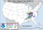
| Sources: SPC Storm Reports for 03/02/12, NWS Huntsville, NWS Birmingham, AL, NWS Morristown, TN, NWS Nashville, NWS Paducah, NWS Louisville, NWS Wilmington, OH, NWS Jackson, KY, NWS Charleston, WV, NWS Jackson, MS, NWS Greenville-Spartanburg, NWS Peachtree City, GA, NCDC Storm Events Database | ||||||
March 3 event
| List of reported tornadoes – Saturday, March 3, 2012 | ||||||
|---|---|---|---|---|---|---|
| | | | | | | |
| North Carolina | ||||||
| EF2 | Harrisburg/Northeast Charlotte area | Mecklenburg, Cabarrus | 35°16′N 80°41′W / 35.26°N 80.68°W | 0734 | 3.2 miles (5.1 km) | Nearly 200 homes were damaged in an area in the northeast fringes of Charlotte; some were destroyed. Vehicles were flipped and storage sheds were destroyed as well. Many trees were downed. Four people were injured, including a child who was thrown across Interstate 485 and found relatively uninjured. |
| South Carolina | ||||||
| EF0 | NNW of Columbia | Richland | 34°04′N 81°46′W / 34.07°N 81.76°W | 1036 | 2.5 miles (4.0 km) | Brief tornado downed trees and tree branches. |
| Georgia | ||||||
| EF0 | ENE of Colquitt | Miller | 31°12′N 84°41′W / 31.20°N 84.68°W | 1215 | 0.25 miles (0.40 km) | Several trees were snapped and a home suffered damage to its roof and porch. |
| EF0 | SSW of Vada | Decatur | 31°03′N 84°26′W / 31.05°N 84.43°W | 1330 | 3.3 miles (5.3 km) | Tornado destroyed a metal frame home, a camper and multiple sheds. Several vehicles and irrigation pivots were also overturned. |
| EF3 | NW of Moody Air Force Base | Lowndes, Lanier | 31°00′N 83°15′W / 31.00°N 83.25°W | 1756 | 10.9 miles (17.5 km) | Large wedge tornado damaged and destroyed several homes and mobile homes. Hundreds of trees were snapped and debarked along the path, some of which had sheet metal wrapped around them. A tractor was thrown and mangled and an electrical meter was pulled from the ground. A wooden 2x4 was impaled through the side of a storage trailer, and a 7-foot piece of metal gutter was driven 2 feet into the ground. In Lakeland, Georgia, an ambulance bay was damaged, along with the roof of a hospital. A full shipping container was blown 50 feet (15 m) as well. |
| Florida | ||||||
| EF0 | S of Quincy | Gadsden | 30°28′N 84°37′W / 30.47°N 84.62°W | 1425 | 0.6 miles (0.97 km) | About two dozen trees were downed in a rural area. |
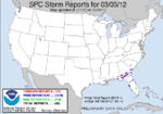
| Sources: SPC Storm Reports for March 3, 2012, NWS Greenville-Spartanburg, NWS Columbia, SC, NWS Tallahassee | ||||||
New Pekin – Henryville, Indiana
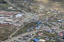
The deadliest tornado of the outbreak was an EF4 that carved a 49 mi (79 km) path of damage from Fredericksburg, Indiana to Bedford, Kentucky. Along its track, the tornado destroyed hundreds of homes and killed 11 people. The most severe damage took place in the small communities of New Pekin, Henryville, Marysville and Chelsea, Indiana.[27]

The tornado first touched down around 2:50 p.m. EST along the south side of Fredericksburg and soon began causing damage. Tracking east-northeast, the storm initially tracked through mainly wooded areas, snapping and uprooting many trees. Several minutes later, the tornado intensified, estimated to be an EF2, and destroyed a "metal power structure." Along State Route 135, the storm further intensified and ripped large chunks of 3 in (7.6 cm) asphalt off roads and tossed them 10 to 30 yd (9.1 to 27.4 m). As it neared the south side of New Pekin, the tornado widened and strengthened even more. By this time, it reached EF4 strength with winds estimated at 170 mph (270 km/h). A large factory was completely leveled and wiped off its foundation and debris was thrown up to 0.75 mi (1.21 km) downwind. Nearby, five people, an entire family, were killed after their mobile home was destroyed.[28] Multiple homes and mobile homes were destroyed in this area. As it neared Clark County, the storm maintained high-end EF3 to EF4 strength. Several more homes were completely destroyed east of New Pekin and a few vehicles were tossed over 100 yd (91 m).[27]
The tornado then struck Henryville, destroying many homes and businesses in the town. Some of the homes were leveled and swept away. A school in town was in the process of dismissing as the tornado struck. Most students left the area before the tornado struck, but a small group of students rode out the tornado inside the school as it was destroyed around them, and survived without major injury. School buses were picked up and thrown, one of which crashed through the wall of a restaurant. Cars were tossed as well, one of which was found with a wooden beam driven through the hood and out of the undercarriage. Hundreds of trees were snapped and debarked along the damage path. Light debris from Henryville was found as far east as Ohio.[27]
The tornado moved east and struck the small town of Marysville. A large section of the community was leveled, with homes completely swept away. Debris was tossed up to a mile away in this area and vehicles were thrown. Numerous farm structures were damaged and destroyed. A church was pushed off its foundation and tree debarking was noted as well. The tornado entered Jefferson County and struck the small community of Chelsea where more homes were leveled and swept away, with debris strewn hundreds of yards. A piece of farm machinery was thrown over 200 yards in this area. The tornado crossed into Trimble County, Kentucky, destroying barns, mobile homes, and downing many trees before dissipating.[27]
Days after the outbreak, a New Pekin resident began helping others recover lost items through a Facebook page called "I Found Your Memory." Items such as high school diplomas were tossed as far away as Cincinnati, Ohio; however, they were able to be returned through this page.[29] Relief centers were opened in the heart of Henryville with the Henryville Community Church becoming the main center over the next weeks and months. On March 8 a long term recovery group, March2Recovery was formed to deal with the aftermath and rebuilding in the five affected counties. By March 14, Federal Emergency Management Agency deployed mobile disaster recovery centers across areas affected by the tornado outbreak. One of these centers was planned to be opened up on March 16 in New Pekin.[30] A local baseball team in southern Indiana began raising money on March 14 to help those injured pay for their medical fees.[31]
West Liberty, Kentucky
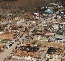
Extensive damage across its path, including extreme damage to buildings in downtown West Liberty, Kentucky.[32] Numerous businesses and homes were destroyed, some of which were leveled. A school had its roof torn off and a church was destroyed as well. Hundreds of trees were snapped and uprooted along the path. There were 10 total fatalities from this tornado with six of them occurring in West Liberty, two near Frenchburg, Kentucky, and two in Blaine, Kentucky; at least 75 people were injured.[25] Tornado was on the ground for 86 miles with a peak wind speed of 165 mph and a peak width of 1 mile.[26] The tornado was the first F3/EF3 in Eastern Kentucky since 1988.
See also
- 2012 Leap Day tornado outbreak, the previous outbreak on February 28 and 29
- Tornadoes of 2012
References
- ↑ National Climatic Data Center. "Billion-Dollar Weather/Climate Disasters". United States National Oceanic and Atmospheric Administration. Retrieved 20 June 2013.
- ↑ "Woman trapped in closet found dead days after tornado". Reuters. March 8, 2012. Retrieved March 9, 2012.
- ↑ Beitler, Stu (October 8, 2007). "Jackson, MS Tornado, Mar 1966". GenDisasters. Retrieved March 4, 2012.
- 1 2 Goss, Steve (March 1, 2012). "March 1, 2012 1730 UTC Day 2 Convective Outlook". Storm Prediction Center. National Oceanic and Atmospheric Administration. Retrieved March 3, 2012.
- ↑ Thompson, Rich; Leitman, Elizabeth (March 2, 2012). "March 2, 2012 1300 UTC Day 1 Convective Outlook". Storm Prediction Center. National Oceanic and Atmospheric Administration. Retrieved March 3, 2012.
- 1 2 3 Jewell, Ryan; Rogers, Jaret (March 2, 2012). "Mar 2, 2012 1630 UTC Day 1 Convective Outlook". Storm Prediction Center. National Oceanic and Atmospheric Administration. Retrieved March 3, 2012.
- ↑ Mead, Corey (March 2, 2012). "PDS Tornado Watch 57". Storm Prediction Center. National Oceanic and Atmospheric Administration. Retrieved March 3, 2012.
- 1 2 Mead, Corey (March 2, 2012). "PDS Tornado Watch 58". Storm Prediction Center. National Oceanic and Atmospheric Administration. Retrieved March 3, 2012.
- ↑ Mead, Corey (March 2, 2012). "Tornado Watch 56". Storm Prediction Center. National Oceanic and Atmospheric Administration. Retrieved March 3, 2012.
- ↑ Mead, Corey (March 2, 2012). "PDS Tornado Watch 62". Storm Prediction Center. National Oceanic and Atmospheric Administration. Retrieved March 3, 2012.
- ↑ Dial, Greg (March 2, 2012). "Mesoscale Discussion 220". Storm Prediction Center. National Oceanic and Atmospheric Administration. Retrieved March 3, 2012.
- ↑ "Daily Weather Maps – Saturday March 3, 2012". The National Weather Service. Retrieved March 4, 2012.
- ↑ Smith, Darrow (March 3, 2012). "Mar 3, 2012 0600 UTC Day 1 Convective Outlook". Storm Prediction Center. National Oceanic and Atmospheric Administration. Retrieved March 4, 2012.
- ↑ Broyles, Chris (March 3, 2012). "Mesoscale Discussion 228". Storm Prediction Center. National oceanic and Atmospheric Administration. Retrieved March 4, 2012.
- ↑ Kerr, Brynn (March 3, 2012). "Mesoscale Discussion 231". Storm Prediction Center. National Oceanic and Atmospheric Administration. Retrieved March 4, 2012.
- ↑ Darrow, Smith. "Mar 4, 2012 0100 UTC Day 1 Convective Outlook". Storm Prediction Center. National Oceanic and Atmospheric Administration. Retrieved March 4, 2012.
- ↑ "SPC Storm Reports for 03/04/12". Storm Prediction Center. National Oceanic and Atmospheric Administration. March 4, 2012. Retrieved March 4, 2012.
- ↑ Stephens, Challen (March 2, 2012). "Buckhorn High School battered by morning tornado, but anticipated to be ready for some classes Monday". The Huntsville Times. Retrieved March 3, 2012.
- ↑ Roop, Lee (March 2, 2012). "Meteorologists say up to 6 tornadoes hit Huntsville, Alabama area in echo of April 2011". The Huntsville Times. Retrieved March 3, 2012.
- ↑ Harrison, Kate (March 6, 2012). "Video: Chattanooga area tornado damage in full view". Chattanooga Times Free Press. Retrieved March 15, 2012.
- ↑ Chris Schilling (March 13, 2012). "Tornado-ravaged Indiana town clears debris, works to find its new definition of 'normal'". The Republic. Archived from the original on March 14, 2012. Retrieved March 14, 2012.
- ↑ TheIndyChannel.com Staff (January 30, 2013). "Deadly Holton tornado claims another life 10 months after ravaging southern Ind. town". ABC 6 Indianapolis. Retrieved March 2, 2013.
- ↑ "Storm destroys Milton Fire & Rescue station". Retrieved March 3, 2012.
- ↑ url=http://www.lex18.com/news/storm-debris-causes-brief-closure-at-cincinnati-northern-kentucky-international-airport/
- 1 2 Spears, Valerie. "Death toll rises to 19; at least 300 injured in Friday's storm". Lexington Herald-Leader. Retrieved March 3, 2012.
- 1 2 url= http://www.kentucky.com/2012/03/05/2096127/more-than-18000-without-power.html
- 1 2 3 4 "March 2, 2012 Tornado Outbreak". National Weather Service office in Louisville, Kentucky. National Oceanic and Atmospheric Administration. March 6, 2012. Retrieved March 7, 2012.
- ↑ Child found in field after tornado dies CBSNews.com. Retrieved October 26, 2015
- ↑ "Facebook helps tornado survivors find lost items". Associated Press. ABC Local News (WLS-TV). March 12, 2012. Retrieved March 15, 2012.
- ↑ "FEMA mobile center in Holton Wednesday, New Pekin Friday". Courier Journal. March 14, 2012. Retrieved March 15, 2012.
- ↑ Jim Johnson (March 14, 2012). "CHS baseball team aids tornado survivors". Journal Review. Retrieved March 15, 2012.
- ↑ "Details on the March 2, 2012 Tornadoes". National Weather Service - Jackson, KY. Retrieved 11 June 2012.