Mount Niblock
| Mount Niblock | |
|---|---|
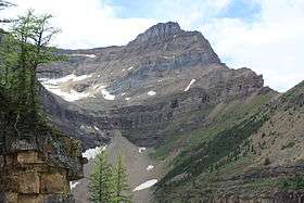 Mount Niblock, August 2012 | |
| Highest point | |
| Elevation | 2,976 m (9,764 ft) [1] |
| Prominence | 142 m (466 ft) [2] |
| Coordinates | 51°25′03″N 116°16′17″W / 51.41750°N 116.27139°WCoordinates: 51°25′03″N 116°16′17″W / 51.41750°N 116.27139°W [3] |
| Geography | |
| Parent range | Bow Range (Canadian Rockies) |
| Topo map | NTS 82N/08 |
| Climbing | |
| First ascent | 1899 by Walter Wilcox[1][2] |
| Easiest route | Moderate scramble |

Mount Niblock is a mountain in Banff National Park near Lake Louise, Alberta, Canada.
The mountain was named in 1904 after John Niblock, a superintendent with the Canadian Pacific Railway. Niblock was an early promoter of tourism in the Rockies and influenced the naming of some of the CPR stops in Western Canada.[1]
Mt. Niblock is a popular scramble in the Lake Louise area and is sometimes combined in the same day with Mount Whyte (2,983 m (9,787 ft)), although the latter is a more difficult scramble. The best time for climbing Mt. Niblock is July through September when the normal route is usually free of snow. Attempting it in the spring or early summer may include significant avalanche hazard.
To access Mt. Niblock, follow the trail as it begins near Chateau Lake Louise, passes Mirror Lake and then Lake Agnes. Follow the right hand shore line trail to the far end of the lake until it begins its left turn towards the Big Beehive. Here an obvious path can be found leading to the lower scree slopes and short cliffs. A more detailed route description can be found in Scrambles in the Canadian Rockies.
Nearby
References
- 1 2 3 "Mount Niblock". PeakFinder.com. Retrieved 2007-08-31.
- 1 2 "Mount Niblock". Bivouac.com. Retrieved 2009-01-02.
- ↑ "Mount Niblock". Geographical Names Data Base. Natural Resources Canada. Retrieved 2013-05-17.
External links
- Mount Niblock Route Beta – Dow Williams