National Register of Historic Places listings in Burt County, Nebraska

Location of Burt County in Nebraska
This is a list of the National Register of Historic Places listings in Burt County, Nebraska.
This is intended to be a complete list of the properties and districts on the National Register of Historic Places in Burt County, Nebraska, United States. The locations of National Register properties and districts for which the latitude and longitude coordinates are included below, may be seen in a map.[1]
There are 11 properties and districts listed on the National Register in the county.
- This National Park Service list is complete through NPS recent listings posted December 16, 2016.[2]
Current listings
| [3] | Name on the Register[4] | Image | Date listed[5] | Location | City or town | Description |
|---|---|---|---|---|---|---|
| 1 | Edward W. and Rose Folsom Bryant House | _from_SE_1.JPG) |
(#04000804) |
104 S. 16th St.[6] 41°46′41″N 96°13′33″W / 41.778056°N 96.225833°W |
Tekamah | |
| 2 | Burt County Courthouse | 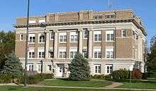 |
(#89002223) |
13th St. between M and N Sts. 41°46′43″N 96°13′13″W / 41.778611°N 96.220278°W |
Tekamah | |
| 3 | Burt County State Bank | 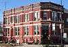 |
(#09000068) |
246 South 13th Street 41°46′34″N 96°13′17″W / 41.7762°N 96.2215°W |
Tekamah | |
| 4 | Deutsche Evangelische Lutherische St. Johannes Kirche | _from_NW.jpg) |
(#82003183) |
Western edge of Section 8, Township 22 North, Range 9 East[7] 41°53′37″N 96°26′39″W / 41.893611°N 96.444167°W |
Lyons | |
| 5 | William and Emma Guhl Farmhouse | _from_ENE_1.JPG) |
(#08000600) |
1560 Nebraska Highway 77[8] 41°53′44″N 96°27′50″W / 41.895556°N 96.464000°W |
Oakland | |
| 6 | E.C. Houston House | 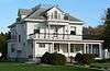 |
(#86000338) |
319 N. 13th St. 41°46′53″N 96°13′14″W / 41.781389°N 96.220556°W |
Tekamah | |
| 7 | Logan Creek Site | _1.JPG) |
(#70000367) |
Address Restricted |
Oakland | |
| 8 | H.S.M. Spielman House | _from_NE_1.JPG) |
(#86001713) |
1103 I St. 41°46′24″N 96°13′06″W / 41.773333°N 96.218333°W |
Tekamah | Home of extremely successful Burt County farmer H.S.M. Spielman; vernacular Queen Anne style with Neoclassical Revival details. |
| 9 | John Henry Stork Log House | _from_NE_1.JPG) |
(#80002442) |
Southwestern corner of Section 26, Township 21 North, Range 11 East[9] 41°45′24″N 96°09′04″W / 41.756667°N 96.151111°W |
Tekamah | |
| 10 | Tekamah Carnegie Library | 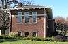 |
(#05000155) |
204 S. 13th St. 41°46′37″N 96°13′17″W / 41.776944°N 96.221389°W |
Tekamah | |
| 11 | Tekamah City Bridge | 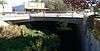 |
(#92000766) |
U.S. Route 75 over Tekamah Creek 41°46′36″N 96°13′15″W / 41.776667°N 96.220833°W |
Tekamah |
See also
- List of National Historic Landmarks in Nebraska
- National Register of Historic Places listings in Nebraska
References
- ↑ The latitude and longitude information provided in this table was derived originally from the National Register Information System, which has been found to be fairly accurate for about 99% of listings. For about 1% of NRIS original coordinates, experience has shown that one or both coordinates are typos or otherwise extremely far off; some corrections may have been made. A more subtle problem causes many locations to be off by up to 150 yards, depending on location in the country: most NRIS coordinates were derived from tracing out latitude and longitudes off of USGS topographical quadrant maps created under the North American Datum of 1927, which differs from the current, highly accurate WGS84 GPS system used by most on-line maps. Chicago is about right, but NRIS longitudes in Washington are higher by about 4.5 seconds, and are lower by about 2.0 seconds in Maine. Latitudes differ by about 1.0 second in Florida. Some locations in this table may have been corrected to current GPS standards.
- ↑ "National Register of Historic Places: Weekly List Actions". National Park Service, United States Department of the Interior. Retrieved on December 16, 2016.
- ↑ Numbers represent an ordering by significant words. Various colorings, defined here, differentiate National Historic Landmarks and historic districts from other NRHP buildings, structures, sites or objects.
- ↑ National Park Service (2008-04-24). "National Register Information System". National Register of Historic Places. National Park Service.
- ↑ The eight-digit number below each date is the number assigned to each location in the National Register Information System database, which can be viewed by clicking the number.
- ↑ Burt County Museum and Bryant House, Nebraska Tourism Commission, n.d. Accessed 2016-10-16.
- ↑ Fagler, James D. "National Register of Historic Places Nomination-Inventory Form: Deutsche Ev. Luth. St. Johannes Kirche". National Park Service: 1982-03, 6.
- ↑ "National Register of Historic Places Registration Form: William and Emma Guhl Farmhouse". Nebraska State Historical Society. Retrieved 2013-06-03.
- ↑ Murphy, D. "National Register of Historic Places Nomination-Inventory Form: John Henry Stork Log House". National Park Service: 1979-12, 5.
External links
| Wikimedia Commons has media related to National Register of Historic Places in Burt County, Nebraska. |
- Nebraska National Register Sites in Burt County–Nebraska State Historical Society
| Topics | |
|---|---|
| Lists by states |
|
| Lists by insular areas | |
| Lists by associated states | |
| Other areas | |
| |
Municipalities and communities of Burt County, Nebraska, United States | ||
|---|---|---|
| Cities | ||
| Villages | ||
| Unincorporated communities | ||
| Townships | ||
| Indian reservations | ||
| Ghost towns | ||
| Footnotes | ‡This populated place also has portions in an adjacent county or counties | |
This article is issued from Wikipedia - version of the 10/18/2016. The text is available under the Creative Commons Attribution/Share Alike but additional terms may apply for the media files.