National Register of Historic Places listings in Denton County, Texas
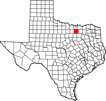
Location of Denton County in Texas
This is a list of the National Register of Historic Places listings in Denton County, Texas.
This is intended to be a complete list of the properties and districts on the National Register of Historic Places in Denton County, Texas, United States. Latitude and longitude coordinates are provided for many National Register properties and districts; these locations may be seen together in a map.[1]
There are 14 properties and districts listed on the National Register in the county. Another property was once listed but has been removed.
- This National Park Service list is complete through NPS recent listings posted December 2, 2016.[2]
Current listings
| [3] | Name on the Register[4] | Image | Date listed[5] | Location | City or town | Description |
|---|---|---|---|---|---|---|
| 1 | Central Roanoke Historic District | .jpg) |
(#08000476) |
100 & 200 blks. of N. Oak St. 32°59′59″N 97°13′43″W / 32.9996°N 97.2287°W |
Roanoke | |
| 2 | Cranston Site | Upload image | (#82004499) |
Address Restricted |
Denton | |
| 3 | Denton County Courthouse | 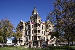 |
(#77001438) |
Public Sq. 33°12′54″N 97°07′58″W / 33.215°N 97.132778°W |
Denton | |
| 4 | Denton County Courthouse Square Historic District | 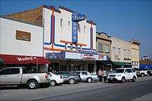 |
(#00001582) |
Area bounded by Pecan, Austin, Walnut, and Cedar Sts. 33°13′26″N 97°08′00″W / 33.223889°N 97.133333°W |
Denton | |
| 5 | Johnson Farm | Upload image | (#94000449) |
Johnson Branch Park 33°25′03″N 97°02′53″W / 33.4175°N 97.048056°W |
Lake Ray Roberts | |
| 6 | Jones Farm | Upload image | (#94001357) |
Johnson Branch Park, Lake Ray Roberts 33°24′53″N 97°02′38″W / 33.414722°N 97.043889°W |
Sanger | |
| 7 | J. C. Lambert Site | Upload image | (#82004500) |
Address Restricted |
Denton | |
| 8 | Old Alton Bridge |  |
(#88000979) |
Copper Canyon Rd. 33°07′45″N 97°06′13″W / 33.129167°N 97.103611°W |
Copper Canyon | |
| 9 | Old Continental State Bank | .jpg) |
(#86001939) |
109 N Oak St. 32°59′57″N 97°13′45″W / 32.999167°N 97.229167°W |
Roanoke | |
| 10 | Pilot Point Commercial Historic District | 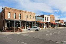 |
(#07000893) |
Portions of eight blocks in downtown Pilot Point centered around the public square 33°23′47″N 96°57′40″W / 33.3963°N 96.9610°W |
Pilot Point | |
| 11 | Rector Road Bridge | 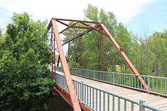 |
(#03001418) |
7501 Teasley Lane 33°08′12″N 97°06′08″W / 33.13667°N 97.10216°W |
Denton | Formerly approximately 2.5 mi (4.0 km). SE of Sanger on Rector Road. Relocated to Guyer High School Grounds in March 2005[6] |
| 12 | Roark-Griffith Site | Upload image | (#82004501) |
Address Restricted |
Denton | |
| 13 | A. H. Serren Site | Upload image | (#82004502) |
Address Restricted |
Denton | |
| 14 | Wilson-Donaldson Site | Upload image | (#82004503) |
Address Restricted |
Denton |
Former listing
| [3] | Name on the Register | Image | Date listed | Date removed | Location | City or town | Summary |
|---|---|---|---|---|---|---|---|
| 1 | Gregory Road Bridge at Duck Creek | Upload image | (#03001419) | Denton County Administrative Complex, intersection of Loop 288 and Morse Road 33°12′12″N 97°05′22″W / 33.203376°N 97.089322°W |
Sanger | Formerly Approx. 0.5 mi (0.80 km). W of Lois Rd., near the N Denton County line. Replaced in 2007.[7] Delisted due to improper relocation.[8] |
See also
| Wikimedia Commons has media related to National Register of Historic Places in Denton County, Texas. |
References
- ↑ The latitude and longitude information provided in this table was derived originally from the National Register Information System, which has been found to be fairly accurate for about 99% of listings. For about 1% of NRIS original coordinates, experience has shown that one or both coordinates are typos or otherwise extremely far off; some corrections may have been made. A more subtle problem causes many locations to be off by up to 150 yards, depending on location in the country: most NRIS coordinates were derived from tracing out latitude and longitudes off of USGS topographical quadrant maps created under the North American Datum of 1927, which differs from the current, highly accurate WGS84 GPS system used by most on-line maps. Chicago is about right, but NRIS longitudes in Washington are higher by about 4.5 seconds, and are lower by about 2.0 seconds in Maine. Latitudes differ by about 1.0 second in Florida. Some locations in this table may have been corrected to current GPS standards.
- ↑ "National Register of Historic Places: Weekly List Actions". National Park Service, United States Department of the Interior. Retrieved on December 2, 2016.
- 1 2 Numbers represent an ordering by significant words. Various colorings, defined here, differentiate National Historic Landmarks and historic districts from other NRHP buildings, structures, sites or objects.
- ↑ National Park Service (2009-03-13). "National Register Information System". National Register of Historic Places. National Park Service.
- ↑ The eight-digit number below each date is the number assigned to each location in the National Register Information System database, which can be viewed by clicking the number.
- ↑ Denton ISD
- ↑
- ↑
| Topics | |
|---|---|
| Lists by states |
|
| Lists by insular areas | |
| Lists by associated states | |
| Other areas | |
| |
This article is issued from Wikipedia - version of the 7/2/2016. The text is available under the Creative Commons Attribution/Share Alike but additional terms may apply for the media files.