National Register of Historic Places listings in Jefferson Davis Parish, Louisiana
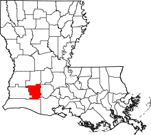
Location of Jefferson Davis Parish in Louisiana
This is a list of the National Register of Historic Places listings in Jefferson Davis Parish, Louisiana.
This is intended to be a complete list of the properties on the National Register of Historic Places in Jefferson Davis Parish, Louisiana, United States. The locations of National Register properties for which the latitude and longitude coordinates are included below, may be seen in a map.[1]
There are 19 properties listed on the National Register in the parish.
- This National Park Service list is complete through NPS recent listings posted December 2, 2016.[2]
Current listings
| [3] |
Name on the Register[4] |
Image |
Date listed[5] |
Location |
City or town |
Description |
|---|
| 1 |
Angelus |
Upload image |
000000001993-04-16-0000April 16, 1993
(#93000296) |
1114 N. Cutting
30°13′53″N 92°39′16″W / 30.231389°N 92.654444°W / 30.231389; -92.654444 (Angelus) |
Jennings |
|
| 2 |
Calkins-Orvis House |
Upload image |
000000001998-05-08-0000May 8, 1998
(#98000438) |
210 W. Nichols
30°14′05″N 92°49′23″W / 30.234722°N 92.823056°W / 30.234722; -92.823056 (Calkins-Orvis House) |
Welsh |
|
| 3 |
Camp Hamilton House |
Upload image |
000000002004-02-17-0000February 17, 2004
(#04000072) |
2200 E. Academy Ave.
30°13′52″N 92°38′02″W / 30.231111°N 92.633889°W / 30.231111; -92.633889 (Camp Hamilton House) |
Jennings |
|
| 4 |
Derouen House |
Upload image |
000000001991-08-05-0000August 5, 1991
(#91001021) |
214 W. Plaquemine
30°13′23″N 92°39′35″W / 30.223056°N 92.659722°W / 30.223056; -92.659722 (Derouen House) |
Jennings |
|
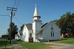
| 5 |
Elton United Methodist Church |
|
000000001994-09-30-0000September 30, 1994
(#94001174) |
803 2nd St.
30°28′44″N 92°41′31″W / 30.478889°N 92.691944°W / 30.478889; -92.691944 (Elton United Methodist Church) |
Elton |
|
| 6 |
Silas J. Fenton House |
Upload image |
000000001994-10-07-0000October 7, 1994
(#94001200) |
409 2nd St.
30°21′48″N 92°55′09″W / 30.363333°N 92.919167°W / 30.363333; -92.919167 (Silas J. Fenton House) |
Fenton |
|
| 7 |
J.E. Foster House |
Upload image |
000000001994-09-30-0000September 30, 1994
(#94001175) |
314 W. Academy Ave.
30°13′28″N 92°39′38″W / 30.224444°N 92.660556°W / 30.224444; -92.660556 (J.E. Foster House) |
Jennings |
|
| 8 |
Fruge Store |
Upload image |
000000001994-09-30-0000September 30, 1994
(#94001176) |
907 Main St.
30°28′51″N 92°41′37″W / 30.480833°N 92.693611°W / 30.480833; -92.693611 (Fruge Store) |
Elton |
|
| 9 |
Funk House |
Upload image |
000000001993-04-01-0000April 1, 1993
(#93000267) |
523 Cary Ave.
30°13′31″N 92°39′34″W / 30.225278°N 92.659444°W / 30.225278; -92.659444 (Funk House) |
Jennings |
|
| 10 |
Ilgenhurst |
Upload image |
000000001993-04-01-0000April 1, 1993
(#93000273) |
402 W. Nezpique
30°13′25″N 92°39′40″W / 30.223611°N 92.661111°W / 30.223611; -92.661111 (Ilgenhurst) |
Jennings |
|
| 11 |
F.R. Jaenke House |
Upload image |
000000001993-04-16-0000April 16, 1993
(#93000301) |
114 Davies Ave.
30°13′54″N 92°39′25″W / 30.231667°N 92.656944°W / 30.231667; -92.656944 (F.R. Jaenke House) |
Jennings |
|
| 12 |
Jennings Carnegie Public Library |
Upload image |
000000001982-01-08-0000January 8, 1982
(#82002776) |
303 Cary Ave.
30°13′34″N 92°39′50″W / 30.226111°N 92.663889°W / 30.226111; -92.663889 (Jennings Carnegie Public Library) |
Jennings |
|
| 13 |
Jennings Post Office |
Upload image |
000000001982-05-20-0000May 20, 1982
(#82002777) |
118 W. Plaquemine St.
30°13′21″N 92°39′34″W / 30.2225°N 92.659444°W / 30.2225; -92.659444 (Jennings Post Office) |
Jennings |
|
| 14 |
T.C. Mahaffey House |
Upload image |
000000001993-04-08-0000April 8, 1993
(#93000292) |
802 Cary
30°13′38″N 92°39′31″W / 30.227222°N 92.658611°W / 30.227222; -92.658611 (T.C. Mahaffey House) |
Jennings |
|
| 15 |
More Mileage Gas Station |
Upload image |
000000002004-06-22-0000June 22, 2004
(#04000637) |
602 N. Main
30°13′32″N 92°39′28″W / 30.225556°N 92.657778°W / 30.225556; -92.657778 (More Mileage Gas Station) |
Jennings |
|
| 16 |
S.A. Pennington House |
|
000000001994-10-07-0000October 7, 1994
(#94001199) |
1003 2nd St.
30°28′43″N 92°41′42″W / 30.478611°N 92.695°W / 30.478611; -92.695 (S.A. Pennington House) |
Elton |
|
| 17 |
Strand Theatre |
Upload image |
000000001998-11-12-0000November 12, 1998
(#98001360) |
432 N. Main St.
30°13′13″N 92°39′19″W / 30.220278°N 92.655278°W / 30.220278; -92.655278 (Strand Theatre) |
Jennings |
|
| 18 |
Sunny Meade |
Upload image |
000000001985-04-18-0000April 18, 1985
(#85000837) |
819 Cary Ave.
30°13′42″N 92°39′37″W / 30.228333°N 92.660278°W / 30.228333; -92.660278 (Sunny Meade) |
Jennings |
|
| 19 |
Twitchell House |
Upload image |
000000001993-04-01-0000April 1, 1993
(#93000268) |
803 Cary Ave.
30°13′40″N 92°39′34″W / 30.227778°N 92.659444°W / 30.227778; -92.659444 (Twitchell House) |
Jennings |
|
See also
References
- ↑ The latitude and longitude information provided in this table was derived originally from the National Register Information System, which has been found to be fairly accurate for about 99% of listings. For about 1% of NRIS original coordinates, experience has shown that one or both coordinates are typos or otherwise extremely far off; some corrections may have been made. A more subtle problem causes many locations to be off by up to 150 yards, depending on location in the country: most NRIS coordinates were derived from tracing out latitude and longitudes off of USGS topographical quadrant maps created under the North American Datum of 1927, which differs from the current, highly accurate WGS84 GPS system used by most on-line maps. Chicago is about right, but NRIS longitudes in Washington are higher by about 4.5 seconds, and are lower by about 2.0 seconds in Maine. Latitudes differ by about 1.0 second in Florida. Some locations in this table may have been corrected to current GPS standards.
- ↑ "National Register of Historic Places: Weekly List Actions". National Park Service, United States Department of the Interior. Retrieved on December 2, 2016.
- ↑ Numbers represent an ordering by significant words. Various colorings, defined here, differentiate National Historic Landmarks and historic districts from other NRHP buildings, structures, sites or objects.
- ↑ National Park Service (2009-03-13). "National Register Information System". National Register of Historic Places. National Park Service.
- ↑ The eight-digit number below each date is the number assigned to each location in the National Register Information System database, which can be viewed by clicking the number.
|
|---|
|
| Topics | |
|---|
|
| Lists by states | |
|---|
|
| Lists by insular areas | |
|---|
|
| Lists by associated states | |
|---|
|
| Other areas | |
|---|
|
-
 Portal Portal
-
 WikiProject WikiProject
|