| [3] |
Name on the Register[4] |
Image |
Date listed[5] |
Location |
City or town |
Description |
|---|
| 1 |
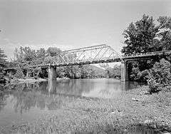
Big Piney Creek Bridge |
|
000000001990-04-09-0000April 9, 1990
(#90000506) |
Highway 123 over Big Piney Creek
35°40′37″N 93°14′10″W / 35.676944°N 93.236111°W / 35.676944; -93.236111 (Big Piney Creek Bridge) |
Hagarville |
|
| 2 |
Bunch-Walton Post #22 American Legion Hut |
|
000000002007-01-24-0000January 24, 2007
(#06001269) |
201 Legion St.
35°28′17″N 93°27′29″W / 35.471389°N 93.458056°W / 35.471389; -93.458056 (Bunch-Walton Post #22 American Legion Hut) |
Clarksville |
|
| 3 |
Clarksville Commercial Historic District |
|
000000002009-03-30-0000March 30, 2009
(#08000816) |
Roughly bounded by McConnell Street on the south, Cherry Street on the north, Johnson Street on the west, and Spadra Creek on the east
35°28′16″N 93°27′59″W / 35.4712°N 93.4663°W / 35.4712; -93.4663 (Clarksville Commercial Historic District) |
Clarksville |
|
| 4 |
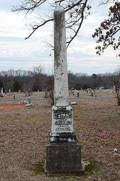
Clarksville Confederate Monument |
|
000000001999-06-25-0000June 25, 1999
(#99000709) |
Oakland Memorial Cemetery, west of Montgomery Ave.
35°28′04″N 93°28′39″W / 35.467778°N 93.4775°W / 35.467778; -93.4775 (Clarksville Confederate Monument) |
Clarksville |
|
| 5 |
Clarksville High School Building No. 1 |
Upload image |
000000001992-09-10-0000September 10, 1992
(#92001202) |
Main St.
35°28′17″N 93°28′20″W / 35.471389°N 93.472222°W / 35.471389; -93.472222 (Clarksville High School Building No. 1) |
Clarksville |
Demolished
|
| 6 |
Clarksville National Guard Armory |
|
000000002007-01-24-0000January 24, 2007
(#06001270) |
309 College St.
35°28′27″N 93°28′00″W / 35.474273°N 93.466586°W / 35.474273; -93.466586 (Clarksville National Guard Armory) |
Clarksville |
|
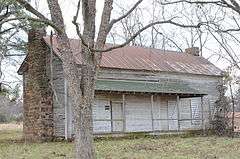
| 7 |
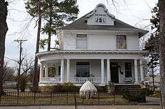
Davis House |
|
000000001982-12-22-0000December 22, 1982
(#82000854) |
212 Fulton St.
35°28′01″N 93°27′57″W / 35.466944°N 93.465833°W / 35.466944; -93.465833 (Davis House) |
Clarksville |
|
| 8 |
N.E. Dickerson Store |
Upload image |
000000001995-09-22-0000September 22, 1995
(#95001124) |
East of Highway 215
35°41′21″N 93°34′23″W / 35.689167°N 93.573056°W / 35.689167; -93.573056 (N.E. Dickerson Store) |
Oark |
|
| 9 |
Dover to Clarksville Road-Hickeytown Road Segment |
|
000000002005-05-26-0000May 26, 2005
(#05000464) |
Hickeytown Rd., east of U.S. Route 64
35°26′06″N 93°22′53″W / 35.435°N 93.381389°W / 35.435; -93.381389 (Dover to Clarksville Road-Hickeytown Road Segment) |
Lamar |
|
| 10 |
Dunlap House |
|
000000001982-12-22-0000December 22, 1982
(#82000855) |
101 Grandview
35°28′15″N 93°27′37″W / 35.470833°N 93.460278°W / 35.470833; -93.460278 (Dunlap House) |
Clarksville |
|
| 11 |
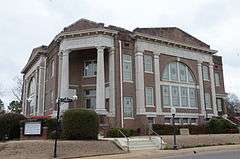
First Presbyterian Church |
|
000000001991-05-13-0000May 13, 1991
(#91000588) |
212 College Ave.
35°28′21″N 93°27′57″W / 35.4725°N 93.465833°W / 35.4725; -93.465833 (First Presbyterian Church) |
Clarksville |
|
| 12 |
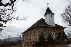
Harmony Presbyterian Church |
|
000000001994-12-01-0000December 1, 1994
(#94001411) |
Northern side of Highway 103, approximately 8 miles north of Clarksville
35°33′02″N 93°34′13″W / 35.550556°N 93.570278°W / 35.550556; -93.570278 (Harmony Presbyterian Church) |
Harmony |
|
| 13 |
Taylor Hill Hotel |
|
000000002008-10-21-0000October 21, 2008
(#08001007) |
409 Alabama St.
35°26′11″N 93°40′15″W / 35.436261°N 93.670767°W / 35.436261; -93.670767 (Taylor Hill Hotel) |
Coal Hill |
|
| 14 |
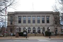
Johnson County Courthouse |
|
000000001991-06-14-0000June 14, 1991
(#91000680) |
Junction of Main and Fulton Sts.
35°28′15″N 93°27′53″W / 35.470833°N 93.464722°W / 35.470833; -93.464722 (Johnson County Courthouse) |
Clarksville |
|
| 15 |
King's Canyon Petroglyphs |
Upload image |
000000001982-05-04-0000May 4, 1982
(#82002119) |
Address Restricted
|
Clarksville |
|
| 16 |
Edward Taylor McConnell House |
|
000000002001-05-10-0000May 10, 2001
(#01000485) |
302 S. Fulton St.
35°28′09″N 93°27′57″W / 35.469167°N 93.465833°W / 35.469167; -93.465833 (Edward Taylor McConnell House) |
Clarksville |
|
| 17 |
McKennon House |
|
000000001982-12-22-0000December 22, 1982
(#82000856) |
115 Grandview
35°28′12″N 93°27′37″W / 35.47°N 93.460278°W / 35.47; -93.460278 (McKennon House) |
Clarksville |
|
| 18 |
Capt. Archibald S. McKennon House |
|
000000001976-01-02-0000January 2, 1976
(#76000424) |
215 N. Central
35°28′22″N 93°27′55″W / 35.472778°N 93.465278°W / 35.472778; -93.465278 (Capt. Archibald S. McKennon House) |
Clarksville |
|
| 19 |
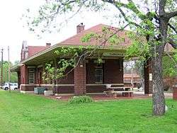
Missouri-Pacific Depot-Clarksville |
|
000000001992-06-11-0000June 11, 1992
(#92000604) |
West of College St. between Cherry and Main Sts.
35°28′18″N 93°28′07″W / 35.471667°N 93.468611°W / 35.471667; -93.468611 (Missouri-Pacific Depot-Clarksville) |
Clarksville |
|
| 20 |
Munger House |
|
000000001996-11-08-0000November 8, 1996
(#96001174) |
West of County Road 416, approximately ¾ mile north of the Pope County line
35°28′35″N 93°15′02″W / 35.476389°N 93.250556°W / 35.476389; -93.250556 (Munger House) |
Lutherville |
|
| 21 |
Raymond Munger Memorial Chapel-University of the Ozarks |
|
000000001993-06-08-0000June 8, 1993
(#93000489) |
West of Highway 103 on the University of the Ozarks campus
35°28′38″N 93°28′03″W / 35.477222°N 93.4675°W / 35.477222; -93.4675 (Raymond Munger Memorial Chapel-University of the Ozarks) |
Clarksville |
|
| 22 |
Oark School-Methodist Church |
Upload image |
000000001995-09-29-0000September 29, 1995
(#95001142) |
Junction of Highway 215 and County Road 34
35°41′28″N 93°34′16″W / 35.6912°N 93.5712°W / 35.6912; -93.5712 (Oark School-Methodist Church) |
Oark |
|
| 23 |
Ozone School |
|
000000002015-01-27-0000January 27, 2015
(#14001200) |
14137 AR 21
35°37′51″N 93°26′34″W / 35.6308°N 93.4429°W / 35.6308; -93.4429 (Ozone School) |
Ozone |
|
| 24 |
Pennington House |
|
000000001994-12-01-0000December 1, 1994
(#94001416) |
317 Johnson St.
35°28′23″N 93°28′09″W / 35.473056°N 93.469167°W / 35.473056; -93.469167 (Pennington House) |
Clarksville |
|
| 25 |
Pioneer House |
|
000000001995-03-31-0000March 31, 1995
(#95000363) |
Poplar St. (U.S. Highway 64), south of Highway 123 and west of the Johnson County Hospital
35°27′47″N 93°26′47″W / 35.463056°N 93.446389°W / 35.463056; -93.446389 (Pioneer House) |
Clarksville |
|
| 26 |
St. Paul Lutheran School |
|
000000001999-03-05-0000March 5, 1999
(#99000228) |
County Road 418
35°28′44″N 93°16′52″W / 35.478889°N 93.281111°W / 35.478889; -93.281111 (St. Paul Lutheran School) |
Lamar |
|
| 27 |
Serpent Cave |
Upload image |
000000001982-05-04-0000May 4, 1982
(#82002120) |
Address Restricted
|
Clarksville |
|
| 28 |
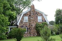
Fremont Stokes House |
|
000000002008-06-04-0000June 4, 2008
(#08000488) |
319 Grandview Ave.
35°27′58″N 93°27′47″W / 35.46605°N 93.463081°W / 35.46605; -93.463081 (Fremont Stokes House) |
Clarksville |
|
| 29 |
Tankersley-Stewart House |
Upload image |
000000001994-05-19-0000May 19, 1994
(#94000464) |
East of County Road 27 and north of Highway 352
35°29′26″N 93°36′36″W / 35.490556°N 93.61°W / 35.490556; -93.61 (Tankersley-Stewart House) |
Hunt |
Demolished.
|
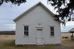
| 30 |
Union School |
|
000000002011-01-24-0000January 24, 2011
(#10001150) |
North side of County Road 4670, west of Little Piney Creek
35°38′04″N 93°19′43″W / 35.634444°N 93.328611°W / 35.634444; -93.328611 (Union School) |
Hagarville vicinity |
Public Schools in the Ozarks MPS; two-room, wood frame schoolhouse erected in 1929; also used as a Masonic Lodge, church and community center[6]
|
| 31 |
U.S. 64 Horsehead Creek Bridge |
|
000000002014-09-29-0000September 29, 2014
(#14000792) |
US 64 over Horsehead Cr.
35°26′06″N 93°36′22″W / 35.4350°N 93.6062°W / 35.4350; -93.6062 (U.S. 64 Horsehead Creek Bridge) |
Hartman |
|