| [3] |
Name on the Register |
Image |
Date listed[4] |
Location |
City or town |
Description |
|---|
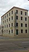
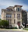
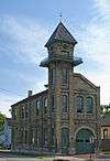
| 1 |
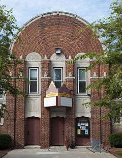
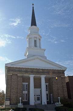
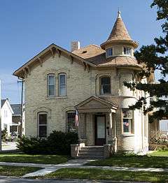
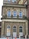
Badger Building |
|
000000001980-12-03-0000December 3, 1980
(#80000174) |
610 Main St.
42°43′36″N 87°46′58″W / 42.726667°N 87.782778°W / 42.726667; -87.782778 (Badger Building) |
Racine |
|
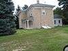
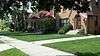
| 2 |
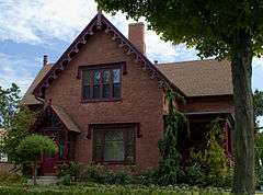
Elam Beardsley Farmhouse |
|
000000001982-03-01-0000March 1, 1982
(#82000699) |
5601 Northwest Hwy.
42°47′28″N 88°15′45″W / 42.791111°N 88.2625°W / 42.791111; -88.2625 (Elam Beardsley Farmhouse) |
Waterford |
|
| 3 |
Burlington Cemetery Chapel |
Upload image |
000000002013-10-09-0000October 9, 2013
(#13000824) |
701 S. Browns Lake Dr.
42°40′56″N 88°15′35″W / 42.682325°N 88.259602°W / 42.682325; -88.259602 (Burlington Cemetery Chapel) |
Burlington |
|
| 4 |
Burlington Community Swimming Pools and Bathhouse |
Upload image |
000000002013-10-23-0000October 23, 2013
(#13000850) |
394 Amanda St.
42°40′48″N 88°17′10″W / 42.680134°N 88.286032°W / 42.680134; -88.286032 (Burlington Community Swimming Pools and Bathhouse) |
Burlington |
|
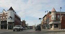
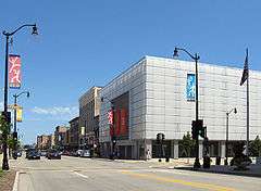
| 5 |
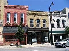
Burlington Downtown Historic District |
|
000000002000-06-02-0000June 2, 2000
(#00000603) |
Roughly bounded by E. Jefferson, N. Pine, E. Washington, E. Chestnut, N. Dodge, Commerce, Mill, and W. Chestnut Sts.
42°40′49″N 88°16′37″W / 42.680278°N 88.276944°W / 42.680278; -88.276944 (Burlington Downtown Historic District) |
Burlington |
|
| 6 |
John Collins House |
Upload image |
000000001974-11-20-0000November 20, 1974
(#74000119) |
6409 Nicholson Rd.
42°48′20″N 87°53′40″W / 42.805556°N 87.894444°W / 42.805556; -87.894444 (John Collins House) |
Caledonia |
|
| 7 |
Eli R. Cooley House |
|
000000001973-04-11-0000April 11, 1973
(#73000273) |
1135 S. Main St.
42°43′09″N 87°46′55″W / 42.719167°N 87.781944°W / 42.719167; -87.781944 (Eli R. Cooley House) |
Racine |
|
| 8 |
Thomas Driver and Sons Manufacturing Company |
|
000000002004-07-14-0000July 14, 2004
(#04000713) |
134 S. Main St., 214 State St.
42°43′55″N 87°47′03″W / 42.731944°N 87.784167°W / 42.731944; -87.784167 (Thomas Driver and Sons Manufacturing Company) |
Racine |
|
| 9 |
First Presbyterian Church |
|
000000001973-03-20-0000March 20, 1973
(#73000093) |
716 College Ave.
42°43′32″N 87°47′07″W / 42.725556°N 87.785278°W / 42.725556; -87.785278 (First Presbyterian Church) |
Racine |
|
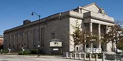
| 10 |
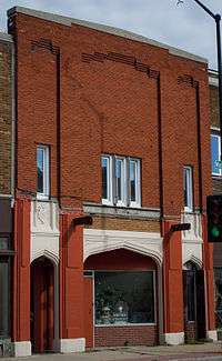
Chauncey Hall Building |
|
000000001980-10-10-0000October 10, 1980
(#80000175) |
338-340 Main St.
42°43′46″N 87°47′00″W / 42.729444°N 87.783333°W / 42.729444; -87.783333 (Chauncey Hall Building) |
Racine |
Designed by E. Townsend Mix
|
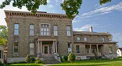
| 11 |
Chauncey Hall House |
|
000000001976-01-02-0000January 2, 1976
(#76000075) |
1235 S. Main St.
42°43′04″N 87°46′55″W / 42.717778°N 87.781944°W / 42.717778; -87.781944 (Chauncey Hall House) |
Racine |
|
| 12 |
Hansen House |
|
000000001979-06-06-0000June 6, 1979
(#79000103) |
1221 N. Main St.
42°44′10″N 87°47′04″W / 42.736111°N 87.784444°W / 42.736111; -87.784444 (Hansen House) |
Racine |
|
| 13 |
Thomas P. Hardy House |
|
000000001974-12-03-0000December 3, 1974
(#74000120) |
1319 S. Main St.
42°42′59″N 87°46′55″W / 42.716389°N 87.781944°W / 42.716389; -87.781944 (Thomas P. Hardy House) |
Racine |
|
| 14 |
Franklyn Hazelo House |
|
000000001974-12-30-0000December 30, 1974
(#74000121) |
34108 Oak Knoll Rd.
42°44′01″N 88°17′23″W / 42.733611°N 88.289722°W / 42.733611; -88.289722 (Franklyn Hazelo House) |
Burlington |
|
| 15 |
Historic Sixth Street Business District |
|
000000001988-03-24-0000March 24, 1988
(#88000263) |
Roughly bounded by Water St. and Fifth St., Main Seventh St., and Grand Ave.
42°43′36″N 87°47′07″W / 42.726667°N 87.785278°W / 42.726667; -87.785278 (Historic Sixth Street Business District) |
Racine |
|
| 16 |
Herbert F. Johnson House |
|
000000001975-01-08-0000January 8, 1975
(#75000076) |
33 E. Four Mile Rd.
42°46′49″N 87°46′16″W / 42.780278°N 87.771111°W / 42.780278; -87.771111 (Herbert F. Johnson House) |
Wind Point |
|
| 17 |
Peter Johnson House |
|
000000001986-01-06-0000January 6, 1986
(#86000053) |
1601 State St.
42°43′54″N 87°48′00″W / 42.731667°N 87.8°W / 42.731667; -87.8 (Peter Johnson House) |
Racine |
|
| 18 |
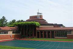
S. C. Johnson and Son Administration Building and Research Tower |
|
000000001974-12-27-0000December 27, 1974
(#74002275) |
1525 Howe St.
42°42′49″N 87°47′27″W / 42.713611°N 87.790833°W / 42.713611; -87.790833 (S. C. Johnson and Son Administration Building and Research Tower) |
Racine |
|
| 19 |
Karel Jonas House |
|
000000001982-03-01-0000March 1, 1982
(#82000700) |
1337 N. Erie St.
42°44′17″N 87°47′13″W / 42.738056°N 87.786944°W / 42.738056; -87.786944 (Karel Jonas House) |
Racine |
Home of Karel Jonas.
|
| 20 |
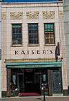
Kaiser's |
|
000000001980-11-25-0000November 25, 1980
(#80000176) |
218 6th St.
42°43′37″N 87°47′01″W / 42.726944°N 87.783611°W / 42.726944; -87.783611 (Kaiser's) |
Racine |
|
| 21 |
Kane Street Historic District |
Upload image |
000000002014-07-25-0000July 25, 2014
(#14000452) |
Generally bounded by Washington & Rudolph Sts., Perkins Blvd., Gardner Ave.
42°40′39″N 88°16′39″W / 42.6776°N 88.2775°W / 42.6776; -88.2775 (Kane Street Historic District) |
Burlington |
|
| 22 |
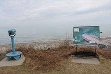
Kate Kelly (Shipwreck) |
|
000000002007-11-21-0000November 21, 2007
(#07001219) |
L. Michigan, 2 mi. E of Wind Pt.
42°46′48″N 87°43′31″W / 42.78°N 87.725278°W / 42.78; -87.725278 (Kate Kelly (Shipwreck)) |
Wind Point |
|
| 23 |
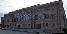
Mitchell Lewis Building |
|
000000002005-04-20-0000April 20, 2005
(#05000334) |
815 Eighth St.
42°43′26″N 87°47′25″W / 42.723889°N 87.790278°W / 42.723889; -87.790278 (Mitchell Lewis Building) |
Racine |
|
| 24 |
Lincoln School |
|
000000001994-08-19-0000August 19, 1994
(#94000999) |
1800 State St.
42°44′06″N 87°48′14″W / 42.735°N 87.803889°W / 42.735; -87.803889 (Lincoln School) |
Racine |
|
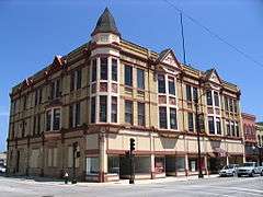
| 25 |
McClurg Building |
|
000000001977-07-13-0000July 13, 1977
(#77000044) |
245 Main St.
42°43′51″N 87°47′00″W / 42.730833°N 87.783333°W / 42.730833; -87.783333 (McClurg Building) |
Racine |
|
| 26 |
Melvin Avenue Residential Historic District |
|
000000002011-11-02-0000November 2, 2011
(#11000788) |
Melvin Ave. generally bounded by Erie & N. Main Sts.
42°45′20″N 87°47′07″W / 42.755556°N 87.785278°W / 42.755556; -87.785278 (Melvin Avenue Residential Historic District) |
Racine |
|
| 27 |
Memorial Hall |
|
000000001980-04-10-0000April 10, 1980
(#80000177) |
72 7th St.
42°43′33″N 87°46′51″W / 42.725833°N 87.780833°W / 42.725833; -87.780833 (Memorial Hall) |
Racine |
|
| 28 |
George Murray House |
|
000000001979-06-06-0000June 6, 1979
(#79000104) |
2219 Washington Ave.
42°42′49″N 87°48′22″W / 42.713611°N 87.806111°W / 42.713611; -87.806111 (George Murray House) |
Racine |
|
| 29 |
No. 4 Engine House |
|
000000001979-06-27-0000June 27, 1979
(#79000102) |
1339 Lincoln St.
42°44′16″N 87°47′20″W / 42.737778°N 87.788889°W / 42.737778; -87.788889 (No. 4 Engine House) |
Racine |
|
| 30 |
Northside Historic District of Cream Brick Workers' Cottages |
|
000000001994-03-16-0000March 16, 1994
(#94000155) |
Roughly bounded by Goold, Erie, English, Main, Yout and Chatham Sts. and Lakeview Community Center
42°44′46″N 87°47′08″W / 42.746111°N 87.785556°W / 42.746111; -87.785556 (Northside Historic District of Cream Brick Workers' Cottages) |
Racine |
|
| 31 |
Norwegian Buildings at Heg Park |
|
000000001980-07-17-0000July 17, 1980
(#80000178) |
NE of Waterford on Heg Park Rd.
42°48′16″N 88°10′22″W / 42.804444°N 88.172778°W / 42.804444; -88.172778 (Norwegian Buildings at Heg Park) |
Waterford |
|
| 32 |
Old Main Street Historic District |
|
000000001987-08-11-0000August 11, 1987
(#87000491) |
Roughly bounded by Second St., Lake Ave., Fifth St., and Wisconsin Ave.
42°43′46″N 87°47′00″W / 42.729444°N 87.783333°W / 42.729444; -87.783333 (Old Main Street Historic District) |
Racine |
|
| 33 |
Orchard Street Historic District |
Upload image |
000000002016-08-22-0000August 22, 2016
(#16000566) |
Generally bounded by Haven & Lindermann Aves., Russet & Kentuckey Sts.
42°43′26″N 87°49′43″W / 42.723789°N 87.828675°W / 42.723789; -87.828675 (Orchard Street Historic District) |
Racine |
|
| 34 |
Racine College |
|
000000001976-12-12-0000December 12, 1976
(#76000076) |
600 21st St.
42°42′22″N 87°47′10″W / 42.706111°N 87.786111°W / 42.706111; -87.786111 (Racine College) |
Racine |
|
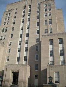
| 35 |
Racine County Courthouse |
|
000000001980-07-28-0000July 28, 1980
(#80000179) |
730 Wisconsin Ave.
42°43′30″N 87°47′03″W / 42.725°N 87.784167°W / 42.725; -87.784167 (Racine County Courthouse) |
Racine |
|
| 36 |
Racine Depot |
|
000000001980-10-10-0000October 10, 1980
(#80000180) |
1402 Liberty St.
42°43′50″N 87°47′52″W / 42.730556°N 87.797778°W / 42.730556; -87.797778 (Racine Depot) |
Racine |
|
| 37 |
Racine Elks Club, Lodge No. 252 |
|
000000001984-09-07-0000September 7, 1984
(#84003778) |
601 Lake Ave.
42°43′37″N 87°46′52″W / 42.726944°N 87.781111°W / 42.726944; -87.781111 (Racine Elks Club, Lodge No. 252) |
Racine |
|
| 38 |
Racine Harbor Lighthouse and Life Saving Station |
|
000000001975-09-09-0000September 9, 1975
(#75000077) |
Racine Harbor North Pier
42°44′03″N 87°46′43″W / 42.734167°N 87.778611°W / 42.734167; -87.778611 (Racine Harbor Lighthouse and Life Saving Station) |
Racine |
|
| 39 |
Racine Public Library |
|
000000001981-03-20-0000March 20, 1981
(#81000056) |
701 S. Main St.
42°43′33″N 87°46′56″W / 42.725833°N 87.782222°W / 42.725833; -87.782222 (Racine Public Library) |
Racine |
|
| 40 |
Racine Rubber Company Homes Historic District |
Upload image |
000000002006-09-27-0000September 27, 2006
(#06000904) |
Roughly bounded by Victory Ave., Republic Ave., Cleveland Ave. and West Boulevard
42°42′44″N 87°49′10″W / 42.712222°N 87.819444°W / 42.712222; -87.819444 (Racine Rubber Company Homes Historic District) |
Racine |
|
| 41 |
Rickeman Grocery Building |
|
000000001982-03-01-0000March 1, 1982
(#82000701) |
415 6th St.
42°43′35″N 87°47′08″W / 42.726389°N 87.785556°W / 42.726389; -87.785556 (Rickeman Grocery Building) |
Racine |
|
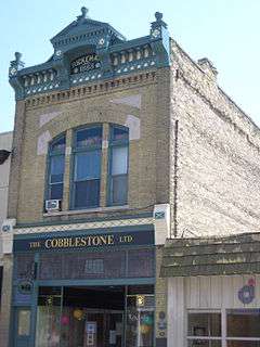
| 42 |
Shoop Building |
|
000000001978-04-26-0000April 26, 1978
(#78000129) |
215 State St.
42°43′53″N 87°47′04″W / 42.731389°N 87.784444°W / 42.731389; -87.784444 (Shoop Building) |
Racine |
|
| 43 |
Southern Wisconsin Home Historic District |
|
000000001991-09-27-0000September 27, 1991
(#91001394) |
21425 Spring St.
42°41′36″N 88°04′52″W / 42.693333°N 88.081111°W / 42.693333; -88.081111 (Southern Wisconsin Home Historic District) |
Dover |
|
| 44 |
Southside Historic District |
|
000000001977-10-18-0000October 18, 1977
(#77000147) |
Roughly bounded by Lake Michigan, DeKoven Ave., Villa and Eighth Sts.
42°42′51″N 87°46′57″W / 42.714167°N 87.7825°W / 42.714167; -87.7825 (Southside Historic District) |
Racine |
|
| 45 |
St. Luke's Episcopal Church, Chapel, Guildhall, and Rectory |
|
000000001979-07-27-0000July 27, 1979
(#79000105) |
614 S. Main St.
42°43′35″N 87°46′59″W / 42.726389°N 87.783056°W / 42.726389; -87.783056 (St. Luke's Episcopal Church, Chapel, Guildhall, and Rectory) |
Racine |
|
| 46 |
St. Patrick's Roman Catholic Church |
|
000000001979-07-05-0000July 5, 1979
(#79000106) |
1100 Erie St.
42°44′04″N 87°47′15″W / 42.734444°N 87.7875°W / 42.734444; -87.7875 (St. Patrick's Roman Catholic Church) |
Racine |
|
| 47 |
United Laymen Bible Student Tabernacle |
|
000000001983-12-08-0000December 8, 1983
(#83004318) |
924 Center St.
42°43′19″N 87°47′23″W / 42.721944°N 87.789722°W / 42.721944; -87.789722 (United Laymen Bible Student Tabernacle) |
Racine |
|
| 48 |
Uptown Theater |
|
000000001982-03-01-0000March 1, 1982
(#82000702) |
1426-1430 Washington Ave.
42°42′57″N 87°47′54″W / 42.715833°N 87.798333°W / 42.715833; -87.798333 (Uptown Theater) |
Racine |
|
| 49 |
US Post Office-Racine Main |
|
000000001985-05-08-0000May 8, 1985
(#85000989) |
603 Main St.
42°43′37″N 87°46′56″W / 42.726944°N 87.782222°W / 42.726944; -87.782222 (US Post Office-Racine Main) |
Racine |
|
| 50 |
Walker Manufacturing Company-Ajax Plant |
Upload image |
000000002016-08-09-0000August 9, 2016
(#16000519) |
1520 Clark St.
42°42′48″N 87°47′42″W / 42.713354°N 87.794945°W / 42.713354; -87.794945 (Walker Manufacturing Company-Ajax Plant) |
Racine |
|
| 51 |
Whitman-Belden House |
|
000000001980-01-17-0000January 17, 1980
(#80000181) |
108 N. State St.
42°44′31″N 88°13′37″W / 42.741944°N 88.226944°W / 42.741944; -88.226944 (Whitman-Belden House) |
Rochester |
|
| 52 |
Wilmanor Apartments |
|
000000001994-06-24-0000June 24, 1994
(#94000649) |
1419-1429 W. Sixth St. and 253-255 N. Memorial Dr.
42°43′32″N 87°47′55″W / 42.725556°N 87.798611°W / 42.725556; -87.798611 (Wilmanor Apartments) |
Racine |
|
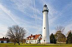
| 53 |
Windpoint Light Station |
|
000000001984-07-19-0000July 19, 1984
(#84003780) |
Windridge Dr. at Lake Michigan
42°46′51″N 87°45′30″W / 42.780833°N 87.758333°W / 42.780833; -87.758333 (Windpoint Light Station) |
Racine |
|
| 54 |
Yorkville #4 School |
|
000000002011-08-04-0000August 4, 2011
(#11000518) |
17640 Old Yorkville Rd.
42°44′31″N 88°01′37″W / 42.741944°N 88.026944°W / 42.741944; -88.026944 (Yorkville #4 School) |
Yorkville |
|
| 55 |
Young Men's Christian Association Building |
|
000000001982-03-01-0000March 1, 1982
(#82000703) |
314-320 6th St.
42°43′36″N 87°47′05″W / 42.726667°N 87.784722°W / 42.726667; -87.784722 (Young Men's Christian Association Building) |
Racine |
|


.jpg)