National Register of Historic Places listings in Spink County, South Dakota

Location of Spink County in South Dakota
This is a list of the National Register of Historic Places listings in Spink County, South Dakota.
This is intended to be a complete list of the properties and districts on the National Register of Historic Places in Spink County, South Dakota, United States. The locations of National Register properties and districts for which the latitude and longitude coordinates are included below, may be seen in a map.[1]
There are 26 properties and districts listed on the National Register in the county. Two previously listed sites have been removed.
- This National Park Service list is complete through NPS recent listings posted December 2, 2016.[2]
Current listings
| [3] | Name on the Register[4] | Image | Date listed[5] | Location | City or town | Description |
|---|---|---|---|---|---|---|
| 1 | William F. Bruell House | Upload image | (#00001222) |
Address Restricted |
Redfield | |
| 2 | Chicago and Northwestern Depot | 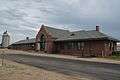 |
(#80003732) |
U.S. Route 212 44°52′30″N 98°31′19″W / 44.875°N 98.521944°W |
Redfield | |
| 3 | First Congregational Church | Upload image | (#79002407) |
Oak and 2nd Sts. 45°03′01″N 98°05′46″W / 45.050278°N 98.096111°W |
Turton | |
| 4 | Harlow Farmstead | Upload image | (#82003940) |
Southwest of Turton 44°57′20″N 98°13′40″W / 44.955556°N 98.227778°W |
Frankfort | |
| 5 | Markham Farmstead | Upload image | (#90000958) |
Junction of County Roads 4 and 7 45°12′01″N 98°12′30″W / 45.200278°N 98.208333°W |
Conde | |
| 6 | Norbeck--Nicholson Carriage House | Upload image | (#14001190) |
910 E. 2nd St. 44°52′24″N 98°30′55″W / 44.873301°N 98.515212°W |
Redfield | |
| 7 | Old Spink Colony | Upload image | (#82003941) |
On the James River 44°44′49″N 98°17′35″W / 44.746944°N 98.293056°W |
Frankfort | |
| 8 | Edbert and Josie Opitz House |  |
(#98001408) |
204 E. 2nd St. 44°52′50″N 98°30′54″W / 44.880556°N 98.515°W |
Redfield | |
| 9 | Redfield Carnegie Library | 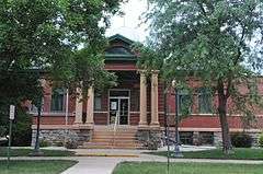 |
(#78002568) |
5 E. 5th Ave. 44°52′34″N 98°31′19″W / 44.876111°N 98.521944°W |
Redfield | |
| 10 | Old Redfield City Hall | 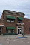 |
(#97000146) |
517 N. Main St. 44°52′07″N 98°30′32″W / 44.868611°N 98.508889°W |
Redfield | |
| 11 | Redfield Light Plant and Fire Station | Upload image | (#78002569) |
614 1st St., E. 44°52′35″N 98°31′01″W / 44.876389°N 98.516944°W |
Redfield | |
| 12 | Salem Church | Upload image | (#97001107) |
208 Ohio St. 44°44′13″N 98°30′27″W / 44.736944°N 98.5075°W |
Tulare | |
| 13 | Site 39SP2 | Upload image | (#84003408) |
Address Restricted |
Frankfort | |
| 14 | Site 39SP4 | Upload image | (#05000590) |
Address Restricted |
Tulare | |
| 15 | Site 39SP12 | Upload image | (#84003403) |
Address Restricted |
Ashton | |
| 16 | Site 39SP19 | Upload image | (#84003405) |
Address Restricted |
Spink Colony | |
| 17 | Site 39SP37 | Upload image | (#84003411) |
Address Restricted |
Crandon | |
| 18 | Site 39SP46 | Upload image | (#84003413) |
Address Restricted |
Crandon | |
| 19 | South Dakota Dept. of Transportation Bridge No. 58-010-376 | Upload image | (#93001313) |
Local road over Wolf Creek 44°41′54″N 98°41′11″W / 44.698333°N 98.686389°W |
Tulare | |
| 20 | South Dakota Dept. of Transportation Bridge No. 58-021-400 | Upload image | (#93001314) |
Local road over Turtle Creek 44°39′46″N 98°39′51″W / 44.662778°N 98.664167°W |
Tulare | |
| 21 | South Dakota Dept. of Transportation Bridge No. 58-025-370 | Upload image | (#93001315) |
Local road over Turtle Creek 44°42′24″N 98°39′19″W / 44.706667°N 98.655278°W |
Tulare | |
| 22 | South Dakota Dept. of Transportation Bridge No. 58-062-270 | Upload image | (#93001316) |
Local road over Turtle Creek 44°51′02″N 98°34′54″W / 44.850556°N 98.581667°W |
Redfield | |
| 23 | South Dakota Dept. of Transportation Bridge No. 58-120-231 | Upload image | (#93001318) |
Local road over the James River 45°57′19″N 98°28′16″W / 45.955278°N 98.471111°W |
Redfield | |
| 24 | South Dakota Dept. of Transportation Bridge No. 58-140-224 | Upload image | (#93001319) |
Local road over the James River 45°53′14″N 98°25′27″W / 45.887222°N 98.424167°W |
Redfield | |
| 25 | South Dakota Dept. of Transportation Bridge No. 58-218-360 | Upload image | (#93001320) |
Local road over the James River 44°43′11″N 98°15′59″W / 44.719722°N 98.266389°W |
Frankfort | |
| 26 | Spink County Courthouse |  |
(#01001219) |
210 E. 7th Ave. 44°52′31″N 98°30′51″W / 44.875278°N 98.514167°W |
Redfield |
Formerly listed
| [3] | Name on the Register | Image | Date listed | Date removed | Location | City or town | Summary |
|---|---|---|---|---|---|---|---|
| 1 | Ashton Methodist Church | Upload image | (#82003939) | Northeastern corner of 2nd Ave. and 2nd St. 44°59′39″N 98°29′55″W / 44.9942°N 98.4986°W |
Ashton | ||
| 2 | Hall Bridge | Upload image | (#93001317) | Local road over Snake Creek |
Ashton | ||
| 3 | James Norwood Round Barn | Upload image | (#78002567) | SE of Ashton on Snake Creek |
Ashton vicinity |
See also
| Wikimedia Commons has media related to National Register of Historic Places in Spink County, South Dakota. |
- List of National Historic Landmarks in South Dakota
- National Register of Historic Places listings in South Dakota
References
- ↑ The latitude and longitude information provided in this table was derived originally from the National Register Information System, which has been found to be fairly accurate for about 99% of listings. For about 1% of NRIS original coordinates, experience has shown that one or both coordinates are typos or otherwise extremely far off; some corrections may have been made. A more subtle problem causes many locations to be off by up to 150 yards, depending on location in the country: most NRIS coordinates were derived from tracing out latitude and longitudes off of USGS topographical quadrant maps created under the North American Datum of 1927, which differs from the current, highly accurate WGS84 GPS system used by most on-line maps. Chicago is about right, but NRIS longitudes in Washington are higher by about 4.5 seconds, and are lower by about 2.0 seconds in Maine. Latitudes differ by about 1.0 second in Florida. Some locations in this table may have been corrected to current GPS standards.
- ↑ "National Register of Historic Places: Weekly List Actions". National Park Service, United States Department of the Interior. Retrieved on December 2, 2016.
- 1 2 Numbers represent an ordering by significant words. Various colorings, defined here, differentiate National Historic Landmarks and historic districts from other NRHP buildings, structures, sites or objects.
- ↑ National Park Service (2008-04-24). "National Register Information System". National Register of Historic Places. National Park Service.
- ↑ The eight-digit number below each date is the number assigned to each location in the National Register Information System database, which can be viewed by clicking the number.
| Topics | |
|---|---|
| Lists by states |
|
| Lists by insular areas | |
| Lists by associated states | |
| Other areas | |
| |
Municipalities and communities of Spink County, South Dakota, United States | ||
|---|---|---|
| Cities | | |
| Towns | ||
| Townships |
| |
| CDP | ||
| Unincorporated communities | ||
| Footnotes | ‡This populated place also has portions in an adjacent county or counties | |
This article is issued from Wikipedia - version of the 5/9/2016. The text is available under the Creative Commons Attribution/Share Alike but additional terms may apply for the media files.