Nepalese Federal States
| Provinces of Nepal | |
|---|---|
 | |
| Category | Federated states |
| Location | Federal Democratic Republic of Nepal |
| Created | 20 September 2015 |
| Number | 7 |
| Government |
Governor Chief Minister |
| Subdivisions | Districts |
 |
| This article is part of a series on the politics and government of Nepal |
| Constitution |
|
Legislature
|
|
Judiciary |
|
| Foreign relations |
|
Related topics |
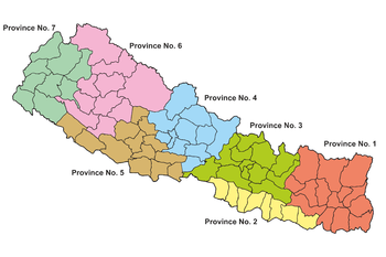
Schedule 4 of the new Constitution of Nepal, adopted on 20 September 2015, provides for the division of the country into 7 federal provinces. These provinces will be formed by grouping together the existing districts. Two districts, however, are to be split between two provinces. According to Article 295 (2), the provinces shall be named by 2/3 vote of the respective province's legislature.
Province No. 1
- 1. Taplejung District
- 2. Panchthar District
- 3. Ilam District
- 4. Sankhuwasabha District
- 5. Terhathum District
- 6. Dhankuta District
- 7. Bhojpur District
- 8. Khotang District
- 9. Solukhumbu District
- 10. Okhaldhunga District
- 11. Udayapur District
- 12. Jhapa District
- 13. Morang District
- 14. Sunsari District
Population 4,534,943 Area 25,905 km.². [1]
Province No. 2
- 1. Saptari District
- 2. Siraha District
- 3. Dhanusha District
- 4. Mahottari District
- 5. Sarlahi District
- 6. Rautahat District
- 7. Bara District
- 8. Parsa District
Population 5,404,145 Area 9,661 km.² [2]
Province No. 3
- 1. Dolakha District
- 2. Ramechhap District
- 3. Sindhuli District
- 4. Kavrepalanchok District
- 5. Sindhupalchok District
- 6. Rasuwa District
- 7. Nuwakot District
- 8. Dhading District
- 9. Chitwan District
- 10. Makwanpur District
- 11. Bhaktapur District
- 12. Lalitpur District
- 13. Kathmandu District
Population 5,529,452 Area 20,300 km.²[3]
Province No. 4
- 1. Gorkha District
- 2. Lamjung District
- 3. Tanahun District
- 4. Kaski District
- 5. Manang District
- 6. Mustang District
- 7. Parbat District
- 8. Syangja District
- 9. Myagdi District
- 10. Baglung District
- 11. Nawalparasi District (east of Bardaghat Susta)
Population 2,413,907 Area 21,504 km.²[4]
Province No. 5
- 1. Nawalparasi District (west of Bardaghat Susta)
- 2. Rupandehi District
- 3. Kapilvastu District
- 4. Palpa District
- 5. Arghakhanchi District
- 6. Gulmi District
- 7. Rukum District (eastern part)
- 8. Rolpa District
- 9. Pyuthan District
- 10. Dang Deukhuri District
- 11. Banke District
- 12. Bardiya District
Population 4,891,025 Area 22,288 km.²[5]
Province No. 6
- 1. Rukum District (western part)
- 2. Salyan District
- 3. Dolpa District
- 4. Jumla District
- 5. Mugu District
- 6. Humla District
- 7. Kalikot District
- 8. Jajarkot District
- 9. Dailekh District
- 10. Surkhet District
Population 1,168,515 Area 27,984 km.²[6]
Province No. 7
- 1. Bajura District
- 2. Bajhang District
- 3. Doti District
- 4. Achham District
- 5. Darchula District
- 6. Baitadi District
- 7. Dadeldhura District
- 8. Kanchanpur District
- 9. Kailali District
Population 2,552,517 Area 19,539 km.²[7]
References
 | ||
This article is issued from Wikipedia - version of the 10/12/2016. The text is available under the Creative Commons Attribution/Share Alike but additional terms may apply for the media files.