North Newton, Kansas
| North Newton, Kansas | |
|---|---|
| City | |
|
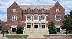
Memorial Hall on Bethel College campus | |
 Location within Harvey County and Kansas | |
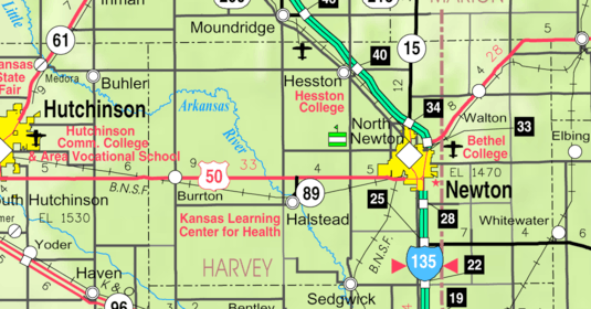 KDOT map of Harvey County (legend) | |
| Coordinates: 38°4′26″N 97°20′47″W / 38.07389°N 97.34639°WCoordinates: 38°4′26″N 97°20′47″W / 38.07389°N 97.34639°W[1] | |
| Country | United States |
| State | Kansas |
| County | Harvey |
| Government | |
| • Type | Council-Manager |
| • Mayor | Ronald Braun[2] |
| • City Admin | John Torline[2] |
| Area[3] | |
| • Total | 0.90 sq mi (2.33 km2) |
| • Land | 0.90 sq mi (2.33 km2) |
| • Water | 0 sq mi (0 km2) |
| Elevation[1] | 1,437 ft (438 m) |
| Population (2010)[4] | |
| • Total | 1,759 |
| • Estimate (2015)[5] | 1,803 |
| • Density | 2,000/sq mi (750/km2) |
| Time zone | CST (UTC-6) |
| • Summer (DST) | CDT (UTC-5) |
| ZIP code | 67117 |
| Area code | 316 |
| FIPS code | 20-51225 [1] |
| GNIS feature ID | 0478000 [1] |
| Website | northnewton.org |
North Newton is a city in Harvey County, Kansas, United States.[1] As of the 2010 census, the city population was 1,759.[6] The city of Newton is located immediately south, existing as a separate political entity. North Newton is home of Bethel College.
History
For millennia, the land now known as Kansas was inhabited by Native Americans. In 1803, most of modern Kansas was secured by the United States as part of the Louisiana Purchase. In 1854, the Kansas Territory was organized, then in 1861 Kansas became the 34th U.S. state. In 1872, Harvey County was founded.
A post office was established as Bethel College on December 19, 1934, then later it was renamed to North Newton on December 1, 1938.[7]
Geography
North Newton is located at 38°4′26″N 97°20′47″W / 38.07389°N 97.34639°W (38.073865, -97.346355)[1] and immediately north of Newton. According to the United States Census Bureau, the city has a total area of 0.90 square miles (2.33 km2), all of it land.[3]
Climate
The climate in this area is characterized by hot, humid summers and generally mild to cool winters. According to the Köppen Climate Classification system, North Newton has a humid subtropical climate, abbreviated "Cfa" on climate maps.[8]
Area attractions
- Kauffman Museum at Bethel College[9]
Demographics
| Historical population | |||
|---|---|---|---|
| Census | Pop. | %± | |
| 1950 | 566 | — | |
| 1960 | 890 | 57.2% | |
| 1970 | 963 | 8.2% | |
| 1980 | 1,222 | 26.9% | |
| 1990 | 1,262 | 3.3% | |
| 2000 | 1,522 | 20.6% | |
| 2010 | 1,759 | 15.6% | |
| Est. 2015 | 1,803 | [5] | 2.5% |
| U.S. Decennial Census | |||
2010 census
As of the census[4] of 2010, there were 1,759 people, 710 households, and 387 families residing in the city. The population density was 1,954.4 inhabitants per square mile (754.6/km2). There were 741 housing units at an average density of 823.3 per square mile (317.9/km2). The racial makeup of the city was 94.7% White, 1.4% African American, 0.6% Native American, 0.9% Asian, 1.0% from other races, and 1.5% from two or more races. Hispanic or Latino of any race were 4.2% of the population.
There were 710 households of which 16.3% had children under the age of 18 living with them, 50.8% were married couples living together, 3.0% had a female householder with no husband present, 0.7% had a male householder with no wife present, and 45.5% were non-families. 43.0% of all households were made up of individuals and 32% had someone living alone who was 65 years of age or older. The average household size was 1.96 and the average family size was 2.69.
The median age in the city was 48.6 years. 13.6% of residents were under the age of 18; 21.2% were between the ages of 18 and 24; 11.5% were from 25 to 44; 20.6% were from 45 to 64; and 33.2% were 65 years of age or older. The gender makeup of the city was 45.7% male and 54.3% female.
2000 census
As of the census[10] of 2000, there were 1,522 people, 604 households, and 335 families residing in the city. The population density was 1,775.4 people per square mile (683.3/km²). There were 632 housing units at an average density of 737.2 per square mile (283.7/km²). The racial makeup of the city was 93.96% White, 2.04% African American, 0.20% Native American, 0.33% Asian, 0.33% Pacific Islander, 1.97% from other races, and 1.18% from two or more races. Hispanic or Latino of any race were 2.83% of the population.[11][12]
There were 604 households out of which 14.7% had children under the age of 18 living with them, 53.6% were married couples living together, 1.3% had a female householder with no husband present, and 44.4% were non-families. 42.2% of all households were made up of individuals and 31.1% had someone living alone who was 65 years of age or older. The average household size was 1.89 and the average family size was 2.55.
In the city the population was spread out with 10.8% under the age of 18, 23.3% from 18 to 24, 12.4% from 25 to 44, 18.1% from 45 to 64, and 35.3% who were 65 years of age or older. The median age was 49 years. For every 100 females there were 79.1 males. For every 100 females age 18 and over, there were 76.5 males.
As of 2000 the median income for a household in the city was $36,974, and the median income for a family was $52,500. Males had a median income of $40,769 versus $23,056 for females. The per capita income for the city was $18,869. About 3.6% of families and 6.8% of the population were below the poverty line, including 5.3% of those under age 18 and 6.8% of those age 65 or over.
Government
The North Newton government consists of a mayor and five council members. The council meets the 2nd Monday of each month at 7PM.[2]
- City Hall, 2601 N Main.
Education
Primary and secondary education
North Newton is part of Unified School District 373.[13]
College
North Newton is home to Bethel College, the oldest Mennonite college in the United States since its founding in 1887.
Infrastructure

Transportation
Interstate I-135 runs along the north side of North Newton.
Utilities
- Internet
- Cable is provided by Cox Communications.
- Wireless is provided by Pixius Communications.
- Satellite is provided by HughesNet, StarBand, WildBlue.
- TV
- Cable is provided by Cox Communications.
- Satellite is provided by DirecTV, Dish Network.
- Terrestrial is provided by regional digital TV stations.
- Telephone
- Landline is provided by AT&T.
- Cellular is provided by AT&T Mobility.
- Electricity
- City is provided by Westar Energy.
- Gas
- Service is provided by Kansas Gas Service.
- Water
- City is provided by City of Newton, billed by City of North Newton.
- Rural is provided by Harvey County RWD #1.
- Sewer
- Service is billed by City of North Newton.
- Trash
- Service is billed by City of North Newton.
Notable people
See also
- List of people from Harvey County, Kansas
- National Register of Historic Places listings in Harvey County, Kansas
- Bethel Threshers
- Threshing Stone
- Chisholm Trail
Further reading
References
- 1 2 3 4 5 6 Geographic Names Information System (GNIS) details for North Newton, Kansas; United States Geological Survey (USGS); October 13, 1978.
- 1 2 3 North Newton - Directory of Public Officials
- 1 2 "US Gazetteer files 2010". United States Census Bureau. Retrieved 2012-07-06.
- 1 2 "American FactFinder". United States Census Bureau. Retrieved 2012-07-06.
- 1 2 "Annual Estimates of the Resident Population for Incorporated Places: April 1, 2010 to July 1, 2015". Retrieved July 2, 2016.
- ↑ "2010 City Population and Housing Occupancy Status". U.S. Census Bureau. Retrieved March 6, 2011.
- ↑ "Kansas Post Offices, 1828-1961 (archived)". Kansas Historical Society. Archived from the original on October 9, 2013. Retrieved 11 June 2014.
- ↑ Climate Summary for North Newton, Kansas
- ↑ Kauffman Museum at Bethel College
- ↑ "American FactFinder". United States Census Bureau. Retrieved 2008-01-31.
- ↑ U.S. Census Bureau - 2000 Census, Population and Housing Unit Counts for Kansas
- ↑ U.S. Census Bureau - 1990 Census, Population and Housing Unit Counts for Kansas
- ↑ Home Page; USD 373.
External links
| Wikimedia Commons has media related to North Newton, Kansas. |
- City
- Schools
- USD 373, school district for Newton, North Newton, Walton
- USD 373 School District Maps
- Bethel College
- Historical
- Harvey County Genealogical Society
- Harvey County Roots
- Rachel Buller - Fighting For Art on YouTube, from Hatteberg's People on KAKE TV news
- Maps
- North Newton City Map, KDOT
- Topo Map of Newton / North Newton / Walton area, USGS
- Harvey County Maps: Current, Historic, KDOT
Municipalities and communities of Harvey County, Kansas, United States | ||
|---|---|---|
| Cities | 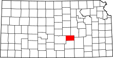 | |
| Unincorporated communities | ||
| Ghost town |
| |
| Townships | ||
| Footnotes | ‡This populated place also has portions in an adjacent county or counties | |