Northern Pacific Railroad Completion Site, 1883
|
Northern Pacific Railroad Completion Site, 1883 | |
  | |
| Location |
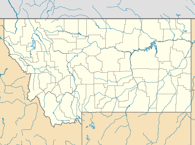
Off Interstate 90 Independence Creek, Montana |
|---|---|
| Coordinates | 46°33′03″N 112°51′36″W / 46.55083°N 112.86000°WCoordinates: 46°33′03″N 112°51′36″W / 46.55083°N 112.86000°W |
| Area | 2.5 acres (1.0 ha) |
| NRHP Reference # | 83001075[1] |
| Added to NRHP | August 19, 1983 |
The Northern Pacific Railroad Completion Site is the location of the golden spike ceremony for the completion of the Northern Pacific Railway in 1883. The site is located near Independence Creek in Powell County, Montana off of Interstate 90,[2] approximately 59 miles (95 km) southeast of Missoula and 40 miles (64 km) west of Helena.[3]
The Northern Pacific Railway began building a transcontinental railroad route across the northern United States from Minnesota to the Pacific Coast in 1870. Crews built from both the eastern and western ends, progressing towards a yet undetermined meeting point somewhere in between. The two crews finally met near Independence Creek in Western Montana on August 22, 1883,[4] which is near Gold Creek where gold was first discovered in Montana.[5] At this point the track was connected, completing the transcontinental line; however, the "golden spike" completion ceremony would not occur until September 8, 1883.[4] Four trains carried 300 guests from the east, including the Northern Pacific's president, Henry Villard, and visiting dignitaries from the United States, England, and Germany.[4] A fifth train arrived from the west coast.[6] The track which had been laid earlier was temporarily torn up to be relaid ceremoniously during the event. The final "golden spike" driven was not actually made of gold, but was the same spike that was driven to begin the construction of the Northern Pacific in Carlton, Minnesota, thirteen years earlier.[4][6] The spike was driven by Villard, former U.S. President Ulysses S. Grant, and Henry C. Davis, who had helped drive the first spike.[4][7][8]
The site was listed on the National Register of Historic Places on August 19, 1983.[1] A wooden sign erected by the Northern Pacific marking the location still exists and can be seen from Interstate 90 near where the Independence Creek runs into the Clark Fork River.[3][9] The 2.5-acre (1.0 ha) site includes the site of the final spike, as well as the location where pavilions were constructed for the 1883 celebrations.[9]
See also
Footnotes
- 1 2 National Register Information System
- ↑ Nolan, Waldron, p. 1.
- 1 2 Google Maps
- 1 2 3 4 5 Nolan, Waldron, p. 3.
- ↑ Gold Creek: Historical Context
- 1 2 Northern Pacific Railroad Company, p. 266.
- ↑ Lubetkin 2006, p. 286.
- ↑ Minnesota Historical Society
- 1 2 Nolan, Waldron, p. 2.
References
- "Gold Creek: Historical Context". Montana Department of Environmental Quality. Retrieved August 9, 2013.
- Google (August 9, 2013). "Goldcreek, Montana" (Map). Google Maps. Google. Retrieved August 9, 2013.
- Lubetkin, M. John (2006). Jay Cooke's Gamble: The Northern Pacific Railroad, the Sioux, and the Panic of 1873. University of Oklahoma Press. ISBN 9780806137407.
- Minnesota Historical Society. "Northern Pacific Railway Company: An Inventory of Its Records at the Minnesota Historical Society". Minnesota Historical Society. Retrieved August 9, 2013.
- "National Register Information System". National Register of Historic Places. National Park Service. 2009-03-13.
- Noan, Ed and Chas. V. Waldron (July 5, 1983). "National Register of Historic Places Inventory Nomination Form: Northern Pacific Railroad Completion Site, 1883" (PDF). National Register of Historic Places.
- Northern Pacific Railroad Company (1893). The Official Northern Pacific Railroad Guide: For the Use of Tourists and Travelers Over the Lines of the Northern Pacific Railroad, Its Branches and Allied Lines. W.C. Riley.
| Topics | |
|---|---|
| Lists by states |
|
| Lists by insular areas | |
| Lists by associated states | |
| Other areas | |
| |