Outer Ring Road, Bangalore
Coordinates: 12°55′29″N 77°40′54″E / 12.924763°N 77.68158°E
Outer Ring Road is a road that runs around most of the perimeter of Bangalore, India. This 62 km long road was developed by the Bangalore Development Authority and different sections were opened progressively between 1996 and 2002.
This road connects all major highways around the city - Tumkur Road (NH 4), Bellary Road (NH 7), Old Madras Road (NH 4), Hosur Road (NH 7), Bannerghatta Road, Kanakapura Road (NH 209), Mysore Road (SH-17) and Magadi Road. It passes through major neighborhoods and suburbs such as Hebbal(NH7), Banaswadi, Krishnarajapuram(NH4), Marathahalli, HSR LAYOUT, Madiwala(NH7), BTM Layout, JP Nagar, Banashankari, Kengeri, Bangalore University, Nagarbhavi, Nandini Layout, Kengeri Upanagara and Gokula.
Initially conceived to keep the truck traffic out of downtown Bengaluru, the city has outgrown the Outer Ring Road. Nandi Infrastructure Corporation Limited has almost completed another partial ring road around Bengaluru as a part of the Bengaluru Mysore Infrastructure Corridor project (BMIC). The BDA and BMRDA have planned three more ring roads beyond the existing ring road.The first of these, the Peripheral ring road will run a few kilometers beyond the BMIC-PRR. The second and third of these will be known as the Intermediate ring road and the satellite towns ring road respectively.[1]
Gallery
- Outer Ring Road Gallery
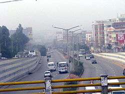
 Bird's eye view of Outer Ring road area
 Innovative Multiplex.
 Road viewed from Cessna Business Park
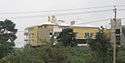 Country Club
 Iblur Flyover At Outer Ring Road
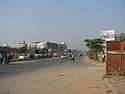 Devarabeesanahalli Outer Ring Road
 KR (Krishna Raja) pura bridge from Narayanapura
 Bhagini's Inn at Mahadevapura during construction
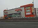 Aditya Birla's More MegaStore at Mahadevapura
 EMC Corporation at Doddanekkondi
 Total mall at Doddenekkondi
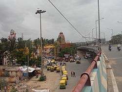 Puri Jagannath's temple and huge Hanuman's idol at Agara
 Puri Jagannath's temple from Agara flyover
 Central Mall near Bellandur
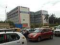 Central silk board at Hosur Road-ORR junction
 360 degree panoramic view of Domlur Flyover
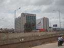 Hotels Novotel and IBIS at Bellandur
Core Ring Road
The Bengaluru Core Ring Road is a proposed expressway system for the congested Indian city of Bangalore. It was proposed by the Bangalore Development Authority as part of a "Master Plan 2005-2015" for improvements to the traffic in the city. The proposal involves overpasses at every junction, a prohibition on right-hand turns, and free left-hand turns, allowing, it is claimed by the proposers, for the smooth and continuous flow of traffic.
The proposed Core Ring Road will accompany the already existing Intermediate Ring Road, Outer Ring Road, and Peripheral Ring Road.
Residential Apartments on Outer Ring Road
- Adarsh Palm Retreat, Outer Ring Road, Bengaluru
- Akme Harmony
- Alpine Eco, Outer Ring Road, Bengaluru
- Sobha Iris
- DSR Regency GreenGlen Layout
- City Lights Liberty Apartments (Near to Pratham Motors, Bellandur Village)
- Suncity Apartments
- Unishire Terraza[2]
- Residential Apartments Gallery
 Aishwarya Opulence
 Akme Harmony
 Utopia Apartment
 Om Heritage
 Sobha Carnation, Dahlia and Florella
 Sobha Florella Under Construction
 Sobha Hibiscus
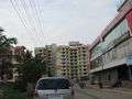 Sobha Mayflower
 Sobha Primrose
 Sobha Quartz
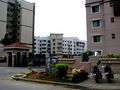 Sobha lavender
Commercial Establishments
- Manyata Embassy Business Park
- Embassy TechVillage
- RMZ Ecospace
- Prestige Tech Park
- J P Morgan
- Cessna business park
See also
References and external links
- ↑ "Peripheral Ring Road work may begin by December". The Hindu. 21 June 2005. Retrieved 29 October 2012.
- ↑ "Unishire Terraza – Location Map". homznspace.com. Retrieved 8 April 2014.
| Wikimedia Commons has media related to Outer Ring Road, Bangalore. |
- Benjamin, Nina (5 August 2002). "On the outer ring of fame". The Hindu. Retrieved 16 December 2008.
- "Work on outer ring road by June". The Times of India. 14 February 2002. Retrieved 16 December 2008.