Varthur
| Varthur ವರ್ತೂರು | |
|---|---|
| Neighbourhood | |
|
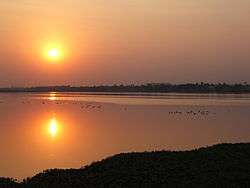
Sunset over Varthur lake. | |
 Varthur | |
| Coordinates: 12°56′27″N 77°44′48″E / 12.940699°N 77.746596°ECoordinates: 12°56′27″N 77°44′48″E / 12.940699°N 77.746596°E | |
| Country | India |
| State | Karnataka |
| District | Bangalore |
| Metro | Bangalore |
| Government | |
| • Body | BBMP |
| Population (January 2010) | |
| • Total | 21,800 |
| Languages | |
| • Official | Kannada |
| Time zone | IST (UTC+5:30) |
| PIN | 560 087 |
| Telephone code | 91-(0)80-2853XXXX |
| Vehicle registration | KA 53 |
| Lok Sabha constituency | Bangalore Central |
| Vidhan Sabha constituency | Mahadevapura |
Varthur (Kannada: ವರ್ತೂರು) is a suburb situated in the Eastern periphery of Bangalore City and part of the internationally famous Whitefield township. Varthur is a Hobli and part of Bruhat Bangalore Mahanagara Palike.[1] Varthur was a Legislative Assembly in the state of Karnataka but, was split into three legislative assemblies C.V.Raman Nagar, Mahadevapura and Krishnarajapura in the year 2008. It is also one of the wards of BBMP. Varthur is very close to ITPB.
There are many IT companies in Varthur Hobli. The head office of one of the largest IT companies, Wipro Technologies is situated at Doddakannelli, Varthur Hobli. Some other companies like Cisco Systems, ARM, Aricent Group, etc. are situated in Varthur Hobli
At Varthur, people celebrate, Brahmarathotsava of Sri Chennaraya Swamy, which happens on the day of Ratha Saptami. It is one of the famous events that happen in this area. Two days later is Karaga of Sri Draupathamma (Draupadi) at Sri Dharmaraya Swamy (Yudhishthira) temple, which happens at night and is visited by thousands of people from Varthur, Gunjur, Madhuranagara, Whitefield, Ramagondannahalli, Balagere, Sorahunase, Immadihalli, Harohalli, Muthsandra, Kotur.
.jpg)
Geography
Varthur is located at 12°56′27″N 77°44′48″E / 12.940699°N 77.746596°E
Administration
- MP Constituency : Bangalore Central
- MLA Constituency : Mahadevapura
- BBMP Ward : Varthur
- MP : P C Mohan (Bharatiya Janata Party (BJP))
- MLA : Aravinda Limbavalli (BJP)
- Councilor: Pushpa Manjunath (BJP)
Educational institutions
- Pratham international school, varthur
- New Horizon College of Engineering
- CMR Institute of Technology
- Krupanidhi Nursing and PU College, Gunjur
- Government Degree College, Varthur
- Government High School and Junior College, Varthur
- Government Middle School, Varthur
- Jnana sagar vidya mandir school, varthur( Near karnataka bank and Dharmaraya temple)
- Sri Sharadha Vidhya Mandir, Varthur
- Ryan International
- K K Education Society
- Vagdhevi Villas (at Varthur and Marathahalli)
- Lady Vailankanni Group of Institutions
- Chrysalis High, Gunjur
- Sri Ravishankar Vidya Mandir
- Vibgyor High, Marathahalli
- Chrysalis High School In, Varthur, Gunjur Main Road
- Vahe Global Academy, Varthur, Gunjur
- Deen's Academy, in whitefield
- Greenwood High near Dommasandra Circle
- TISB International School near Dommasandra Circle
- Inventure Academy near Dommasandra Circle
- Oakridge International School near Dommasandra Circle
- Indus International School in Dommasandra Circle
- Abhijatha Education Society (SLF Convent)
- Jnana sagar vidya mandir( Near Dharmaraya temple and karnataka bank )
- Whitefield Global School (Near Hope Farm Circle)
- Lady Vailankanni Group of Institutions (varthur)
Varthur Main Road
The stretch starting from HAL old Airport road till Varthur via Marathahalli, Kundanahalli, Thubarahalli, Sidhapura, Ramagundanahalli and Varthur Kodi is officially known as Varthur Main Road.
Varthur lake
The lake ecosystem is an integral part of Bangalore, although unplanned urbanisation and industrialisation have led to the contamination of these water bodies. Varthur Lake, which has an area of 180.40 hectares (445.8 acres) is the second largest lake[2] in Bangalore city and also one of the most polluted[3] lakes in Bangalore. Its ecosystem is under continuous degradation because of sewage water from Bangalore, entering the lake from Bellandur Lake further upstream.
This is a man made lake, built by Ganga kings over thousands of years ago[2] for agriculture and domestic uses but now the lake is receiving 40% of the sewage water from Bangalore for over 50 years resulting in eutrophication.
Gallery
 Sree Chennaraya Swamy
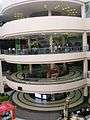 Forum Value Mall
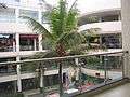 Forum Value Mall
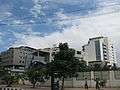 Sigma Technology Park
Geographic Location
 |
Whitefield | | ||
| Marathahalli | |
Madhuranagar | ||
| ||||
| | ||||
| Gunjur |
References
| Wikimedia Commons has media related to Varthur. |