Petroleum County, Montana
| Petroleum County, Montana | |
|---|---|
.jpg) Petroleum County Courthouse in Winnett | |
 Location in the U.S. state of Montana | |
 Montana's location in the U.S. | |
| Founded | February 25, 1925 |
| Named for | Petroleum fields |
| Seat | Winnett |
| Largest town | Winnett |
| Area | |
| • Total | 1,674 sq mi (4,336 km2) |
| • Land | 1,655 sq mi (4,286 km2) |
| • Water | 19 sq mi (49 km2), 1.1% |
| Population (est.) | |
| • (2015) | 475 |
| • Density | 0.3/sq mi (0/km²) |
| Congressional district | At-large |
| Time zone | Mountain: UTC-7/-6 |
| Website |
www |
Petroleum County is a county located in the U.S. state of Montana. As of the 2010 census, the population was 494,[1] making it the least populous county in Montana and the seventh-least populous in the United States.[2] Its county seat is Winnett.[3] The Montana Legislature approved the formation of the county by separating it from Fergus County; Petroleum County was thus created on February 25, 1925, as the last of Montana's 56 counties.[4][5]
History
The area was home to Native American hunter gatherer tribes of the Crow, Blackfoot, Nez Perce, and Sioux. In 1868, a trading post was established at the mouth of this river and was named Musselshell.[4] The county seat, Winnett,was named for Walter John Winnett. He was a Canadian rancher who was captured by Sioux and later adopted into the tribe; he was given the name Eagle Eyes because of his remarkable shooting skills. Winnett established a ranch in Montana Territory in 1879 near an active trading post and the Hangman's Tree used by vigilantes in the area.[6] The massive ranch house, which he built in 1900, housed his own family and served as a gathering place for the community. Winnett built up a freight line business to haul supplies from Billings. In 1910, he built a store and petitioned for a post office—and with that, Winnett became an official town.[7] Fort Magginis was built in 1880 and thereafter, live stock farming proliferated. At that time, gold was also found in Fergus County, which was the original county from which Petroleum County was carved out. During the period from 1911 to 1915, stakes in the county were claimed by an influx of settlers with claims limited to 320 acres (130 ha) of land to each settler and squatter. However, in 1930 many of these lands reverted to the Government as settlers deserted the town.[8]
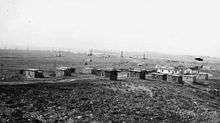
Oil was discovered at the Cat Creek Oil Field on February 18, 1920, at the southeast corner of the county. Petroleum found in the Cat Creek was of high grade and extraction of crude oil started soon. In 1922, the crude oil extracted was 2.2 million barrels.
The county got its present name, "Petroleum County", from its status as the site of the first major oil discovery in Montana.[5] When the state government established Petroleum County in 1925, splitting it from Fergus County, Winnett became the county seat and the county was named after the emerging petroleum industry of Cat Creek.[4]
The county was always one of the most sparsely populated areas of the US, and the population has continued to decline as rural folk move out to more populated areas to find work. According to the 1930 census, there were 2,045 people living in the county, with 408 people living in the county seat of Winnett.[9] The county was brought under administrative format of the "county manager" in 1944. By the time of the 1980 census, there were just 685 people living in the county.[10]
Geography

The county’s eastern boundary is formed by the Musselshell River. According to the U.S. Census Bureau, the county has a total area of 1,674 square miles (4,340 km2), of which 1,655 square miles (4,290 km2) is land and 19 square miles (49 km2) (1.1%) is water.[11] Its land topography lies in an elevation range of 2,250–4,000 feet (690–1,220 m). The land lies in the Missouri Plateau section of the Great Plains. The uplands are generally of fairly level land and valleys while the general topography is of rolling hills and valleys except for sharp gullies on the side slopes of Missouri and Musselshell Rivers in certain stretches. The southern part of the county also consists of moderate hill slopes and gentle valleys, interspersed with steep cliffs in some stretches.[12]
Petroleum County is bordered to the north by Phillips County, Garfield County to the east, Rosebud County to the southeast, Musselshell County to the south, and Fergus County to the west. Notable towns in the county include Winnett, Cat Creek, Flatwillow, Kelley, and Teigen. State Highway 200 passes through the middle of county, State Highway 244 from the east end is from Winnet to the county, U.S. Route 87 passes through the southwest corner of the county. There is also a network of internal roads that connect to various places in the county.[13] A Tyrannosauridae fossil skeleton was discovered in the Judith River Formation,[14] while Alamosaurus was discovered in the Hell Creek Formation.[15]

_1986_01.jpg)
Rivers running through the county include the Missouri River and Musselshell River. The Musselshell River is drained mostly by its tributaries within the county. However, the northern tributaries drain into the Missouri River and eventually into the Fort Peck Reservoir. The creeks which flow through the county are all ephemeral in nature, flowing only during the rainy season, while the larger creeks have formed flood plains which are composed mainly of silt, clay and to some extent sand and pebbles. There are several creeks, including Bender Creek, Bear Creek, and the other creeks are the Flat Willow Creek, Bender Creek, Box Elder Creek, Brickyard Creek, Buffalo Creek, Cat Creek, Cottonwood Creek, Sacagawea River, and Dovetail Creek.[16][17] Wild Horse Lake is located in the county formed in a natural depression. Some of the important lakes and reservoirs in the county are: Little Bear Lake, Wild Horse Lake, War Horse Lake, Petrolia Lake, War Horse Lake, Yellow Water Reservoir and Headman-Field Reservoir.[17] Only the northern part of the county is rich in surface water resources, but there is hardly any agricultural land to use it. In the rest of the county, the reliance for agricultural use is on ground water.[18]
Climate
The mean annual precipitation recorded is 13 inches (330 mm). The mean annual temperature is in the range of 42–47 °F (6–8 °C). Frost is recorded during the season for 105–135 days.[19]
While rainfall is 13 inches (330 mm) in Flatwillow, it is 16 inches (410 mm) at Grass Range, and 13 inches (330 mm) at Mosby; at these locations, the mean winter temperatures are 24 °F (−4 °C), 25 °F (−4 °C) and 23 °F (−5 °C) respectively. The lowest temperature recorded at Mosby was on January 24, 1969, of −43 °F (−42 °C). The maximum temperature recorded was 108 °F (42 °C) on July 19, 1960, at Flatwillow. Nearly 70% of rainfall occurs from April to September, also the growing season for many crops in the county. The average seasonal snowfall is 40 in (100 cm) at Flatwillow, 63 in (160 cm) at Grass Range and 36 in (91 cm) at Mosby. Average wind speed is about 17 miles per hour (7.6 m/s) which is highest during the winter.[20]
Protected areas
.jpg)
The War Horse National Wildlife Refuge is a protected area in the county. The Charles M. Russell National Wildlife Refuge is located in the northern region of the county. It provides opportunities for hunting, fishing, boating, backpacking and other recreational activities.[8]
Geology

A sandstone ridge with steep dips passes through the county starting from the Musselshell River in the northern end running up to the boundary on the west end of the county. This geological feature, an anticline, is petroleum-bearing. The anticline divides the county into two geological regions - one is to the north of the anticline with geological formations of Bearpaw Shale or the Hill Creek Formation while the other region, to the south of the anticline, is of formations containing older Cretaceous rocks. Marine shales (generally in dark gray turning to black color), classified under the geological formations of the Colorado Group, are found as outcrops throughout the county and these are of Cretaceous age. Sandstones are also noted in alternate sequences and these are identified at deeper depths in Cat Creek. Of the anticlines noted in the area, the Cat Creek Anticline, which runs in an east–west direction is dominant.[18]
Flora and fauna
Rangeland contains wheatgrass, forbs, shrubs, green needlegrass, blue grama, big sagebrush, plains pricklypear, wooly indianwheat, weedlike forbs, broom snakeweed, Nuttal saltbush, prairie sandreed, horizontal juniper, plains reedgrass, golden pea, and prairie rose. Forest land covers 64,296 acres of which 6,500 acres are characterized as commercial forest land; Ponderosa pine, Douglas fir, and Plains cottonwood are noted. The forest understory features obtuse sedge, creeping juniper, Rocky Mountain juniper, bluebunch wheatgrass, Little lbuestern, and hawksbeard.[21]
The wild life found in the country are elk, white-tailed deer, mule deer and pronghorn antelope. These provide for good hunting opportunities.[8] The pheasant population has been increasing in the county, eagles frequent War Horse Lake,[22] and Gray, or Hungarian, partridge are an introduced species.
Economy
As of March 2012, the cost of living index in the county was a low 82.2 below the national average of 100.[17] The main economic activity is centered on petroleum and beef. Livestock farming accounts for 89% of the farm income. In the stockyards of Billings and Lewistown, the ranchers market their livestock and sometimes they sell to buyers directly from their ranches. The two towns also have elevators from where crops grown by the ranchers are marketed.[8] Refineries are located in Billings which receives crude through pipes from the Cat Creek Oil Field and also from the Rattlesnake Butte.[8] Agriculture, forestry, fishing and hunting are attributed to 66% of the population. Mining accounts for 58.2% of people in the county while in educational, health and social services 15.5% of people are engaged.[17] Some of the notable ranches in the county are: McArthur Ranch, Maxwell Ranch, Crooked Creek Campground, Fail Ranch, and Novak Homestead.[17] As of 2012, the average size of farms was 6,045 acres and the area under all harvested wheat grain was 14,720 acres (5,960 ha).[17] The major crops grown in the county are wheat (both winter wheat and spring wheat) and barley. Alfalfa and grass hay are grown as cattle feed[8] under irrigated conditions along the main river course and also on the banks of creeks such as Flat Willow, Box Elder, and Macdonald.
Demographics

| Historical population | |||
|---|---|---|---|
| Census | Pop. | %± | |
| 1930 | 2,045 | — | |
| 1940 | 1,083 | −47.0% | |
| 1950 | 1,026 | −5.3% | |
| 1960 | 894 | −12.9% | |
| 1970 | 675 | −24.5% | |
| 1980 | 655 | −3.0% | |
| 1990 | 519 | −20.8% | |
| 2000 | 493 | −5.0% | |
| 2010 | 494 | 0.2% | |
| Est. 2015 | 475 | [23] | −3.8% |
| U.S. Decennial Census[24] 1790-1960[25] 1900-1990[26] 1990-2000[27] 2010-2015[1] | |||
As of the 2010 United States Census, there were 494 people, 225 households, and 143 families residing in the county.[28] The population density was 0.3 inhabitants per square mile (0.12/km2). There were 324 housing units at an average density of 0.2 per square mile (0.077/km2).[29] The racial makeup of the county was 98.8% white, 0.0% from other races, and 1.2% from two or more races. Those of Hispanic or Latino origin made up 1.0% of the population.[28] In terms of ancestry, 35.1% were German, 15.9% were Norwegian, 15.7% were English, 13.2% were Irish, and 3.5% were American.[30]
Of the 225 households, 28.0% had children under the age of 18 living with them, 55.1% were married couples living together, 4.0% had a female householder with no husband present, 36.4% were non-families, and 35.1% of all households were made up of individuals. The average household size was 2.20 and the average family size was 2.83. The median age was 47.3 years.[28]
The median income for a household in the county was $36,875 and the median income for a family was $39,107. Males had a median income of $25,991 versus $21,705 for females. The per capita income for the county was $21,008. About 18.1% of families and 16.7% of the population were below the poverty line, including 26.3% of those under age 18 and 12.7% of those age 65 or over.[31]
Communities
Town
- Winnett (county seat)
Unincorporated communities
See also
- List of cemeteries in Petroleum County, Montana
- List of lakes in Petroleum County, Montana
- List of mountains in Petroleum County, Montana
- National Register of Historic Places listings in Petroleum County, Montana
References
- 1 2 "State & County QuickFacts". United States Census Bureau. Retrieved September 16, 2013.
- ↑ "Top 10: Least Populous Counties, During the Period of 2005-2009". PolicyMap. 2011-02-28. Retrieved 2013-07-07.
- ↑ "Find a County". National Association of Counties. Retrieved 2011-06-07.
- 1 2 3 Ellie Arguimbau; Ellen Baumler; Charlene L. Porsild; Brian Shovers (2009). Montana Place Names: From Alzada to Zortman. Montana Historical Society. pp. 204–. ISBN 978-0-9759196-1-3.
- 1 2 SoilsIndustry 1993, pp. 1-2.
- ↑ The Montana Almanac. Montana State University. 1958. p. 404. Retrieved 25 June 2013.
- ↑ "Winnett". Montana Community Information. Retrieved 25 June 2013.
- 1 2 3 4 5 6 SoilsIndustry 1993, pp. 1-3.
- ↑ Montana. Dept. of Agriculture and Publicity (1933). Resources and Opportunities of Montana. Independent Publishing Company, State Printers. pp. 117–8. Retrieved 25 June 2013.
- ↑ Diggs, David M.; Sweeney, Patrick (1985). Who owns the West: sixteen case studies on natural resource ownership. Western Organization of Resource Councils. Retrieved 25 June 2013.
- ↑ "2010 Census Gazetteer Files". United States Census Bureau. August 22, 2012. Retrieved November 29, 2014.
- ↑ SoilsIndustry 1993, pp. 2-4.
- ↑ SoilsIndustry 1993, p. 2.
- ↑ Parrish, J. Michael; Molnar, Ralph E.; Currie, Philip J.; Koppelhus, Eva B. (26 June 2013). Tyrannosaurid Paleobiology. Indiana University Press. pp. 5–. ISBN 978-0-253-00947-0.
- ↑ Geology of the Big Bend area, Texas: field trip guidebook with road log and papers on natural history of the area. West Texas Geological Society. 1972. p. 21.
- ↑ Hyatt, H. Norman (2009). An Uncommon Journey: Book One in the Quaternion of the History of Old Dawson County, Montana Territory : the Biography of Stephen Norton Van Blaricom : a True Story of the First Settlers of the Last West. Farcountry Press. p. 256. ISBN 978-1-59152-056-6. Retrieved 25 June 2013.
- 1 2 3 4 5 6 "Petroleum County, Montana (MT)". City data.com. Retrieved 26 June 2013.
- 1 2 SoilsIndustry 1993, pp. 3-4.
- ↑ SoilsIndustry 1993, p. 1.
- ↑ SoilsIndustry 1993, pp. 7-8.
- ↑ SoilsIndustry 1993, pp. 98-103.
- ↑ United States. Bureau of Land Management (1979). Draft environmental statement on grazing management in the Missouri Brakes of Montana. Montana State Office. pp. 2–36–.
- ↑ "County Totals Dataset: Population, Population Change and Estimated Components of Population Change: April 1, 2010 to July 1, 2015". Retrieved July 2, 2016.
- ↑ "U.S. Decennial Census". United States Census Bureau. Retrieved November 29, 2014.
- ↑ "Historical Census Browser". University of Virginia Library. Retrieved November 29, 2014.
- ↑ "Population of Counties by Decennial Census: 1900 to 1990". United States Census Bureau. Retrieved November 29, 2014.
- ↑ "Census 2000 PHC-T-4. Ranking Tables for Counties: 1990 and 2000" (PDF). United States Census Bureau. Retrieved November 29, 2014.
- 1 2 3 "DP-1 Profile of General Population and Housing Characteristics: 2010 Demographic Profile Data". United States Census Bureau. Retrieved 2016-01-10.
- ↑ "Population, Housing Units, Area, and Density: 2010 - County". United States Census Bureau. Retrieved 2016-01-10.
- ↑ "DP02 SELECTED SOCIAL CHARACTERISTICS IN THE UNITED STATES – 2006-2010 American Community Survey 5-Year Estimates". United States Census Bureau. Retrieved 2016-01-10.
- ↑ "DP03 SELECTED ECONOMIC CHARACTERISTICS – 2006-2010 American Community Survey 5-Year Estimates". United States Census Bureau. Retrieved 2016-01-10.
Bibliography
- United States Bureau of Chemistry and Soils; United States. Bureau of Plant Industry; United States. Bureau of Plant Industry, Soils, and Agricultural Engineering; United States. Soil Conservation Service, United States. Natural Resources Conservation Service (1993). Soil survey. U.S. Dept. of Agriculture. Cite uses deprecated parameter
|coauthors=(help)
External links
| Wikimedia Commons has media related to Petroleum County, Montana. |
Municipalities and communities of Petroleum County, Montana, United States | ||
|---|---|---|
| Town | | |
| Unincorporated communities | ||
Coordinates: 47°07′N 108°16′W / 47.11°N 108.26°W