Jefferson County, Montana
| Jefferson County, Montana | |
|---|---|
|
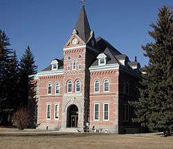
Jefferson County Courthouse in Boulder | |
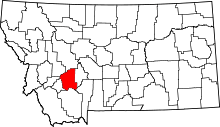 Location in the U.S. state of Montana | |
 Montana's location in the U.S. | |
| Founded | February 2, 1865[1] |
| Named for | Thomas Jefferson |
| Seat | Boulder |
| Largest town | Boulder |
| Area | |
| • Total | 1,659 sq mi (4,297 km2) |
| • Land | 1,656 sq mi (4,289 km2) |
| • Water | 2.6 sq mi (7 km2), 0.2% |
| Population (est.) | |
| • (2015) | 11,645 |
| • Density | 6.9/sq mi (3/km²) |
| Congressional district | At-large |
| Time zone | Mountain: UTC-7/-6 |
| Website |
www |
Jefferson County is a county located in the U.S. state of Montana. As of the 2010 census, the population was 11,406.[2] Its county seat is Boulder.[3] The county was created in 1865[4] and named for President Thomas Jefferson.[5]
Jefferson County is part of the Helena, MT Micropolitan Statistical Area.
Geography
According to the U.S. Census Bureau, the county has a total area of 1,659 square miles (4,300 km2), of which 1,656 square miles (4,290 km2) is land and 2.6 square miles (6.7 km2) (0.2%) is water.[6]
Major highways
Adjacent counties
- Lewis and Clark County, Montana - north
- Broadwater County, Montana - east
- Gallatin County, Montana - southeast
- Madison County, Montana - south
- Silver Bow County, Montana - west
- Deer Lodge County, Montana - west
- Powell County, Montana - northwest
National protected areas
- Deerlodge National Forest (part)
- Helena National Forest (part)
Demographics
| Historical population | |||
|---|---|---|---|
| Census | Pop. | %± | |
| 1870 | 1,531 | — | |
| 1880 | 2,464 | 60.9% | |
| 1890 | 6,026 | 144.6% | |
| 1900 | 5,330 | −11.5% | |
| 1910 | 5,601 | 5.1% | |
| 1920 | 5,203 | −7.1% | |
| 1930 | 4,133 | −20.6% | |
| 1940 | 4,664 | 12.8% | |
| 1950 | 4,014 | −13.9% | |
| 1960 | 4,297 | 7.1% | |
| 1970 | 5,238 | 21.9% | |
| 1980 | 7,029 | 34.2% | |
| 1990 | 7,939 | 12.9% | |
| 2000 | 10,049 | 26.6% | |
| 2010 | 11,406 | 13.5% | |
| Est. 2015 | 11,645 | [7] | 2.1% |
| U.S. Decennial Census[8] 1790-1960[9] 1900-1990[10] 1990-2000[11] 2010-2015[2] | |||
2000 census
As of the census[12] of 2000, there were 10,049 people, 3,747 households, and 2,847 families residing in the county. The population density was 6 people per square mile (2/km²). There were 4,199 housing units at an average density of 2 per square mile (1/km²). The racial makeup of the county was 96.07% White, 0.14% Black or African American, 1.26% Native American, 0.42% Asian, 0.07% Pacific Islander, 0.38% from other races, and 1.66% from two or more races. 1.48% of the population were Hispanic or Latino of any race. 22.9% were of German, 13.1% English, 12.9% Irish, 7.9% Norwegian and 5.3% American ancestry.
There were 3,747 households out of which 35.60% had children under the age of 18 living with them, 67.10% were married couples living together, 5.90% had a female householder with no husband present, and 24.00% were non-families. 20.20% of all households were made up of individuals and 7.30% had someone living alone who was 65 years of age or older. The average household size was 2.62 and the average family size was 3.03.
In the county the population was spread out with 27.80% under the age of 18, 5.20% from 18 to 24, 26.80% from 25 to 44, 29.90% from 45 to 64, and 10.30% who were 65 years of age or older. The median age was 40 years. For every 100 females there were 100.80 males. For every 100 females age 18 and over, there were 100.40 males.
The median income for a household in the county was $41,506, and the median income for a family was $48,912. Males had a median income of $34,753 versus $25,011 for females. The per capita income for the county was $18,250. About 6.70% of families and 9.00% of the population were below the poverty line, including 10.40% of those under age 18 and 9.60% of those age 65 or over.
2010 census
As of the 2010 United States Census, there were 11,406 people, 4,512 households, and 3,301 families residing in the county.[13] The population density was 6.9 inhabitants per square mile (2.7/km2). There were 5,055 housing units at an average density of 3.1 per square mile (1.2/km2).[14] The racial makeup of the county was 95.5% white, 1.4% American Indian, 0.4% Asian, 0.1% black or African American, 0.4% from other races, and 2.2% from two or more races. Those of Hispanic or Latino origin made up 2.0% of the population.[13] In terms of ancestry, 31.3% were German, 19.1% were Irish, 17.2% were English, 10.8% were Norwegian, and 4.2% were American.[15]
Of the 4,512 households, 28.8% had children under the age of 18 living with them, 63.7% were married couples living together, 5.4% had a female householder with no husband present, 26.8% were non-families, and 22.6% of all households were made up of individuals. The average household size was 2.48 and the average family size was 2.90. The median age was 46.2 years.[13]
The median income for a household in the county was $56,695 and the median income for a family was $67,195. Males had a median income of $50,978 versus $34,148 for females. The per capita income for the county was $26,437. About 2.7% of families and 12.8% of the population were below the poverty line, including 5.1% of those under age 18 and 8.6% of those age 65 or over.[16]
Communities
Towns
Census-designated places
Ghost towns
See also
- List of cemeteries in Jefferson County, Montana
- List of lakes in Jefferson County, Montana
- List of mountains in Jefferson County, Montana
- National Register of Historic Places listings in Jefferson County, Montana
References
- ↑ http://genealogytrails.com/mon/countytimeline.html
- 1 2 "State & County QuickFacts". United States Census Bureau. Retrieved September 15, 2013.
- ↑ "Find a County". National Association of Counties. Retrieved 2011-06-07.
- ↑ "Montana Place Names Companion". Montana Place Names From Alzada to Zortman. Montana Historical Society Research Center. Retrieved December 1, 2014.
- ↑ Gannett, Henry (1905). The Origin of Certain Place Names in the United States. Govt. Print. Off. p. 168.
- ↑ "2010 Census Gazetteer Files". United States Census Bureau. August 22, 2012. Retrieved November 28, 2014.
- ↑ "County Totals Dataset: Population, Population Change and Estimated Components of Population Change: April 1, 2010 to July 1, 2015". Retrieved July 2, 2016.
- ↑ "U.S. Decennial Census". United States Census Bureau. Retrieved November 28, 2014.
- ↑ "Historical Census Browser". University of Virginia Library. Retrieved November 28, 2014.
- ↑ "Population of Counties by Decennial Census: 1900 to 1990". United States Census Bureau. Retrieved November 28, 2014.
- ↑ "Census 2000 PHC-T-4. Ranking Tables for Counties: 1990 and 2000" (PDF). United States Census Bureau. Retrieved November 28, 2014.
- ↑ "American FactFinder". United States Census Bureau. Retrieved 2008-01-31.
- 1 2 3 "DP-1 Profile of General Population and Housing Characteristics: 2010 Demographic Profile Data". United States Census Bureau. Retrieved 2016-01-10.
- ↑ "Population, Housing Units, Area, and Density: 2010 - County". United States Census Bureau. Retrieved 2016-01-10.
- ↑ "DP02 SELECTED SOCIAL CHARACTERISTICS IN THE UNITED STATES – 2006-2010 American Community Survey 5-Year Estimates". United States Census Bureau. Retrieved 2016-01-10.
- ↑ "DP03 SELECTED ECONOMIC CHARACTERISTICS – 2006-2010 American Community Survey 5-Year Estimates". United States Census Bureau. Retrieved 2016-01-10.
 |
Powell County | Lewis and Clark County | | |
| Silver Bow County and Deer Lodge County | |
Broadwater County | ||
| ||||
| | ||||
| Madison County | Gallatin County |
Municipalities and communities of Jefferson County, Montana, United States | ||
|---|---|---|
| Towns | | |
| CDPs | ||
| Unincorporated communities | ||
Coordinates: 46°11′N 112°07′W / 46.18°N 112.11°W