Purcell Mountains
| Purcell Mountains | |
|---|---|
 | |
| Geography | |
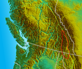 Location map of the Purcell Mountains | |
| Countries | Canada and United States |
| Provinces/States | British Columbia, Montana and Idaho |
| Range coordinates | 49°55′N 116°15′W / 49.92°N 116.25°WCoordinates: 49°55′N 116°15′W / 49.92°N 116.25°W |
| Parent range | Columbia Mountains |
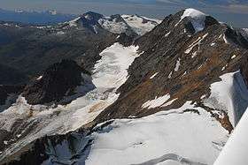
The Purcell Mountains are a mountain range in southeastern British Columbia, Canada.[1] They are a subrange of the Columbia Mountains, which includes the Selkirk, Monashee, and Cariboo Mountains. They are located on the west side of the Rocky Mountain Trench in the area of the Columbia Valley, and on the east side of the valley of Kootenay Lake and the Duncan River.[2][3] The only large settlement in the mountains is the Panorama Ski Resort, though there are small settlements, such as Yahk and Moyie along the Crowsnest Highway, and residential rural areas dependent on the cities of Creston, Kimberley and Cranbrook, which are located adjacent to the range.
The Purcells are shown on some United States maps as the Percell Mountains, where their southern limit protrudes into the states of Idaho and Montana, abutting Lake Koocanusa, a reservoir on the Kootenai River.[4] American geographic classifications consider the Percells to be part of the Rocky Mountains but in Canada that terminology is reserved for ranges on the east side of the Rocky Mountain Trench. In the Purcell Mountains, most of the peaks are near or above 10,000 feet in elevation.
The Purcells were formed in the Proterozoic eon (in the Precambrian period), which spans from 2,500 million years ago to about 540 million years ago.
Sub-ranges
- Carbonate Range
- Dogtooth Range
- Farnham Group
- MacBeth Group
- McGillivary Range
- Moyie Range
- Septet Range
- Spillimacheen Range
- Starbird Ridge
- Stockdale Group
- Toby Glacier
- Truce Group
- Yahk Range
See also
References
- ↑ BCGNIS entry "Purcell Mountains"
- ↑ Landforms of British Columbia: A Physiographic Outline, by S. Holland 1964 (revised 1976), British Columbia Ministry of Energy, Mines and Petroleum Resources
- ↑ Landforms of British Columbia: A Physiographic Outline- Physiographic map, by S. Holland 1964 (revised 1976), British Columbia Ministry of Energy, Mines and Petroleum Resources
- ↑ U.S. Geological Survey Geographic Names Information System: Purcell Mountains