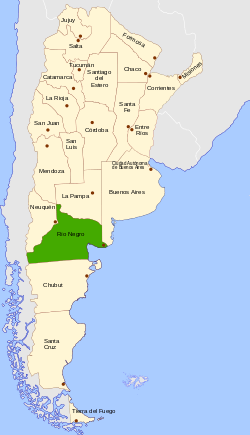
Río Negro Province
| Río Negro | |||
|---|---|---|---|
| Province | |||
| |||
 | |||
| Coordinates: 40°48′S 63°00′W / 40.800°S 63.000°WCoordinates: 40°48′S 63°00′W / 40.800°S 63.000°W | |||
| Country | Argentina | ||
| Capital | Viedma | ||
| Divisions | 13 departments | ||
| Government | |||
| • Governor | Alberto Weretilneck | ||
| • Senators | Silvina Gacía Larraburu, Miguel Ángel Pichetto, Magdalena Odarda | ||
| Area | |||
| • Total | 203,013 km2 (78,384 sq mi) | ||
| Population (2010[1]) | |||
| • Total | 638,645 | ||
| • Rank | 15th | ||
| • Density | 3.1/km2 (8.1/sq mi) | ||
| Demonym(s) | Rionegrino | ||
| Time zone | ART | ||
| ISO 3166 code | AR-R | ||
| Website |
rionegro | ||


Río Negro (Spanish pronunciation: [ˈri.o ˈneɣɾo], Black River) is a province of Argentina, located at the northern edge of Patagonia. Neighboring provinces are from the south clockwise Chubut, Neuquén, Mendoza, La Pampa and Buenos Aires. To the east lies the Atlantic Ocean.
Its capital is Viedma. Other important cities include the ski resort town of Bariloche, Cipolletti and General Roca.
History
Ferdinand Magellan was the first explorer to visit the coasts of the provinces in 1520. Priest Nicolás Mascardi founded the Jesuit mission Nuestra Senora de Nahuel Huapi in 1670 at the shore of the Nahuel Huapi Lake, at the feet of the Andes range.

Originally part of the Argentine territory called Patagonia (in 1878 the Gobernación de la Patagonia[2]), in 1884 it was organised into the Territorio Nacional del Río Negro and General Lorenzo Vintter was appointed as the territory's first governor. It was only in 1957,[3] that Río Negro acquired status of a province; its first provincial governor was Edgardo Castello of the Radical Civic Union (UCR).[4]
Geography

Río Negro is one of the six provinces that make up Argentine Patagonia.[5] It is bounded to the north by the Colorado River which separates it from La Pampa Province, to the east by the Atlantic Ocean and to the west by the Andes and the Limay River (serves as the natural border with Neuquén Province).[5] The 42nd parallel south marks the southern limit of the province.[5] With an area of 203,013 square kilometres (78,383.8 sq mi), it is the 4th largest province by area.[6]
The main water source at the arid plains that cover most of the province is the Río Negro River, in whose valley most of the settlements and farms are located. The over 600 km of the Rio Negro's valley are divided in Alto Valle (West), Valle Medio (center) and Valle Inferior (East).
The central part of the province is dominated by a series of plateaus and isolated hills, with altitudes ranging from 600 meters (2000 ft) above sea level to 1000 meters (3300 ft). Especially noteworthy is the plateau called "Meseta de Somuncura" in the central-eastern part of the province, with altitudes generally above 1000 meters (3300 ft) and some spots reaching 1300 meters (4200 ft). Moving further west, the foothills of the Andes are dominated by a series of low valleys discharging either towards the Atlantic through the Limay river, or to the Pacific through the Manso and Puelo rivers: deep blue-water lakes form in the Andean valleys, with some regions reaching very low altitudes (under 400 meters, or 1300 ft, in the Pacific basin, and 750 meters, or 2500 ft, in the Atlantic basin). The Andes are here deeply cut by glacial valleys, and the altitude of the peaks is moderate: for most, it ranges between 1,700 meters and 2,200 meters (5600 to 7200 ft), with only a handful of peaks surpassing 2,400 meters (7800 ft). Especially noteworthy is the Cerro Tronador, a heavily glaciated peak of 3,405 meters (11,100 ft) which dominates the surrounding landscape.

Climate
The climate of the province is temperate at low elevations, and very cold in the higher Andean peaks.
Temperature
The mean annual temperatures in the province are relatively cold for its latitude owing to the cold Malvinas Current to the east and higher altitude to the west.[7] Mean annual temperatures in the province can vary, depending on altitude and distance from the sea.[7] The northern parts of the province are the warmest, with a mean annual temperature of more than 15 °C (59.0 °F) while the coldest areas are found in the Andean region where the mean annual temperatures are less than 10 °C (50.0 °F).[7] At the highest peaks, the mean annual temperature is less than freezing.[7] Summers are hot throughout the province with the exception of the Andean region with mean January temperatures ranging from 20 to 24 °C (68.0 to 75.2 °F).[7] Occasionally, temperatures can exceed 40 °C (104.0 °F) during heat waves in all areas except for the Andean region.[7] In contrast, the Andean region has milder summers with mean January temperatures of 15 °C (59.0 °F) or less, depending on the altitude.[7] Winters are cool to cold. In July, mean temperatures range from 7 to 8 °C (44.6 to 46.4 °F) on the coast in the north to around 2 to 3 °C (35.6 to 37.4 °F) in the central plateau area and the Andean region.[7] The central plateau area can be extremely cold during the winter in which temperatures can fall to −25 °C (−13.0 °F) while the coastal areas are milder with temperatures that can fall to −15 °C (5.0 °F).[7]
Humidity and Precipitation
Relative humidity is lower in the central plateau where they average 50%.[7] Along the coastal regions, humidity is higher with a mean annual humidity of 60% while the Andean region has the highest humidity with an average annual humidity exceeding 65% due to the lower temperatures there.[7] In all locations, humidity is lower in the summer and higher in the winter owing to the higher temperatures in the summer.[7]
The Andes block most of the moisture from the Pacific Ocean from coming in, causing it to release most of the precipitation on its western slopes and as such, most of the province is dry, with a mean annual precipitation around 200 millimetres (8 in).[7] Coastal areas and northern parts of the province receive a slightly higher precipitation, where it can average above 300 millimetres (12 in) a year.[7] The Andean region receives the most precipitation with areas receiving a mean annual precipitation of 200 to 1,000 millimetres (8 to 39 in) in which the precipitation gradient is very strong and increases westwards.[7] In some places, precipitation can exceed 3,000 millimetres (118 in) a year.[7] Most of the Andean region has a rainfall pattern that is Mediterranean like, similar to Central Chile in which most of the precipitation falls during the winter months and summers are dry.[7]
Wind and Sunshine
One dominant characteristic of the climate is the strong winds that are observed throughout the province.[7] Summers tend to be windier than winters.[7] Winds coming from the west, southwest and northwest are common, occurring 50% of the time (60% if calm winds are not included).[7] There is some tendency for the winds to come from the east, particularly on the coastal regions when sea breezes from the east can occur when westerly winds are weak, which can be felt up to 10 kilometres (6.2 mi) from the coast.[7] The mean wind speed throughout the province varies with the northern parts having the lowest wind speeds while the highest altitude areas being the windiest.[7] Except for the northern parts of the province, mean annual wind speeds exceed 4 metres per second (13 ft/s).[7]
Cloud cover varies throughout the province, ranging from more than 60% in the Andean region to about 40% in the coastal areas.[7] The central plateaus have intermediate amounts of cloud cover between these 2 regions.[7] As such, the Andean region is more cloudier than the rest of the province.[7] Sunshine ranges from 10–11 hours of sunshine/day in January to about 5 hours of sunshine/day (less cloudier areas) to less than 3 hours of sunshine/day (more cloudier areas) in July.[7]
Demographics
| Historical population | ||
|---|---|---|
| Year | Pop. | ±% |
| 1895 | 9,241 | — |
| 1914 | 42,242 | +357.1% |
| 1947 | 134,350 | +218.0% |
| 1960 | 193,292 | +43.9% |
| 1970 | 262,622 | +35.9% |
| 1980 | 383,354 | +46.0% |
| 1991 | 506,772 | +32.2% |
| 2001 | 552,822 | +9.1% |
| 2010 | 638,645 | +15.5% |
| Source: [8] | ||
According to the results from the 2010 census [INDEC], the province has a population of 638,645 with 316,774 males and 321,871 females.[8] It constitutes 1.6% of the total population in Argentina.[9]:63 This represented a 15.5% increase in the population compared to 2001 census [INDEC] which had 552,822 inhabitants.[8] Amongst of all the provinces in Patagonia[note 1], it is the most populous, containing 30.4% of the total population in Patagonia.[note 1][10]
Government
As of January 2012 Alberto Weretilneck became governor of the province, following the death of the Peronist Carlos Soria on New Years Day.[11]
Economy
Argentina's ninth-largest, Rio Negro's economy is a diversified service-based one with vigorous agricultural and light manufacturing sectors. Its 2006 output was an estimated US$5.420 billion, or a per capita income of US$9,805.[12] In 2013, its output increased to $43.349 billon Pesos (about US$7.939 billion) at current market prices.[13][14]

There is a gold mine located at Calcatreu, near Ingeniero Jacobacci, that is owned by Pan American Silver.[15] in December 2011 the provincial government repealed a law banning the use of cyanide in mineral processing, and the mine's owners regarded this as a positive development which is likely to bring increased investment.[16]
Tourism
.jpg)
There are two main areas of tourism in the province; the Andes and the Atlantic coast.
- The Andean Area
The most visited area is that of the lake district near San Carlos de Bariloche inside the Nahuel Huapi National Park, and neighbouring Neuquén Province. This includes the Isla Victoria, Camino de los Siete Lagos, Los Arrayanes National Park, and many trekking paths among lakes.
- The Atlantic Coast
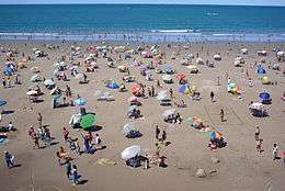
Returns of Southern Right Whales are possibly the biggest of tourism attractions.[17] They swim and rest very close to shore, and the San Matías Gulf is the only place in the world where swimming with this kind is commercially permitted.[18]
Wineries

Region is known for its white varietals Semillon and Sauvignon blanc, and its red varietals Merlot, Pinot noir and Malbec.[19]
Political division

The province is divided into 13 departments:
Department (Capital)
- Adolfo Alsina Department (Viedma)
- Avellaneda Department (Choele Choel)
- Bariloche Department (San Carlos de Bariloche)
- Conesa Department (General Conesa)
- El Cuy Department (El Cuy)
- General Roca Department (General Roca)
- 9 de Julio Department (Sierra Colorada)
- Ñorquinco Department (Ñorquincó)
- Pichi Mahuida Department (Río Colorado)
- Pilcaniyeu Department (Pilcaniyeu)
- San Antonio Department (San Antonio Oeste)
- Valcheta Department (Valcheta)
- 25 de Mayo Department (Maquinchao)
Source for department names:[20]

References
- ↑ "Censo 2010 Argentina resultados definitivos: mapas". 200.51.91.231. Retrieved 2012-08-15.
- ↑ Law Nº 954, of 11 October 1878
- ↑ Law Nº 14,408 of 15 June 1955 authorized the creation of the province, but this was not accomplished until 1957.
- ↑ "Breve Historia del Edificio de la Legislatura". Legislatura de Río Negro. Archived from the original on 24 August 2011.
- 1 2 3 "Reseña Geografía" (in Spanish). Gobierno de Río Negro. Retrieved 15 December 2015.
- ↑ "División Política, Superficie y Población" (in Spanish). Instituto Geográfico Nacional. Retrieved 15 December 2015.
- 1 2 3 4 5 6 7 8 9 10 11 12 13 14 15 16 17 18 19 20 21 22 23 24 25 26 27 "Provincia de Río Negro–Clima Y Metéorologia" (in Spanish). Secretaria de Mineria de la Nacion (Argentina). Archived from the original on November 2, 2014. Retrieved June 30, 2014.
- 1 2 3 "Población de la Provincia de Río Negro por sexo. Año 1895–2010" (in Spanish). Dirección de Estadísticas y Censos de la Provincia de Río Negro. Retrieved 15 December 2015.
- ↑ "Censo Nacional de Población, Hogares y Viviendas 2010: Resultados definitivos: Serie B No 2: Tomo 1" (PDF) (in Spanish). INDEC. Retrieved 15 December 2015.
- ↑ "La Patagonia–Cuestiones demográficas de la tierra del fin del mundo" (PDF) (in Spanish). Dirección Provincial de Estadísticas y Censos de la Provincia del Neuquén. Retrieved 15 December 2015.
- ↑ "Argentine governor Carlos Soria killed by gunshot". BBC. 1 January 2012. Retrieved 6 October 2012.
- ↑ "El déficit consolidado de las provincias rondará los $11.500 millones este año" (in Spanish). Instituto Argentino para el Desarrollo de las Economías Regionales. Retrieved 10 July 2015.
- ↑ "Indicadores Económicos" (in Spanish). Dirección de Estadística y Censos de la Provincia de Río Negro. Retrieved 10 July 2015.
- ↑ The average exchange for 1 US dollar was 5.46 Argentine pesos in 2013 according to the World Bank
- ↑ "Calcatreu". Operations. Pan American Silver. Retrieved 6 October 2012.
- ↑ Dorothy Kosich (20 January 2012). "Boost for gold mining as Argentina's Rio Negro Province repeals cyanide ban". Mineweb. Moneyweb Holdings. Retrieved 6 October 2012.
- ↑ http://www.patagonia.com.ar/Las+Grutas/691E_Whales+also+choose+Las+Grutas.html
- ↑ http://www.rufford.org/rsg/projects/els_vermeulen
- ↑ WinesofArgentina.org
- ↑ "Departments". ARGENTINA: Río Negro. Citypopulation.de. Retrieved 22 November 2012.
Notes
- 1 2 Argentine Patagonia includes the provinces of Río Negro, Neuquén, Chubut, Santa Cruz, and Tierra del Fuego