Radøy
| Radøy kommune | |||
|---|---|---|---|
| Municipality | |||
.jpg) | |||
| |||
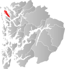 Radøy within Hordaland | |||
| Coordinates: 60°40′09″N 05°02′10″E / 60.66917°N 5.03611°ECoordinates: 60°40′09″N 05°02′10″E / 60.66917°N 5.03611°E | |||
| Country | Norway | ||
| County | Hordaland | ||
| District | Nordhordland | ||
| Administrative centre | Manger | ||
| Government | |||
| • Mayor (2007) | Jon Askeland (Sp) | ||
| Area | |||
| • Total | 111.44 km2 (43.03 sq mi) | ||
| • Land | 106.80 km2 (41.24 sq mi) | ||
| • Water | 4.64 km2 (1.79 sq mi) | ||
| Area rank | 379 in Norway | ||
| Population (2014) | |||
| • Total | 5,039 | ||
| • Rank | 199 in Norway | ||
| • Density | 47/km2 (120/sq mi) | ||
| • Change (10 years) | 7.7 % | ||
| Demonym(s) | Radværing[1] | ||
| Time zone | CET (UTC+1) | ||
| • Summer (DST) | CEST (UTC+2) | ||
| ISO 3166 code | NO-1260 | ||
| Official language form | Nynorsk | ||
| Website |
www | ||
|
| |||


Radøy is an island municipality in the Nordhordland district in Hordaland county, Norway. The municipality includes almost all of the island of Radøy plus many small surrounding islands. The administrative centre of the municipality is the village of Manger. Other villages in the municipality include Askeland, Austmarka, Bøvågen, Haugland, Sæbø, and Sletta.
General information
The municipality of Radøy was created as a new municipality on 1 January 1964, after a major municipal merger. The new municipality was constructed from parts of several different municipalities:[2]
- all of the municipality of Manger (population: 1,344)
- all of the municipality of Hordabø (population: 1,679)
- the island of Bognøy from Herdla municipality (population: 29)
- most of the municipality of Sæbø, except the Titland area on the Lindås peninsula (population: 916)
- the Sletta area on the island of Radøy from Lindås municipality (population: 305)
- the Straume area on the island of Radøy and the small island of Fesøy from Austrheim municipality (population: 56)
Name
The municipality was named after the island on which it sits, Radøy. The Old Norse form of the island's name was (just) Röð. (The last element øy meaning "island" was added later.) The name is identical with the word röð for "row" or "ridge" (here in the sense "long island" sticking out of the ocean).[3]
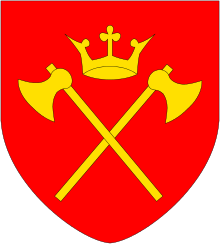
Coat-of-arms
The coat-of-arms is from modern times; they were granted on 16 June 1991. The arms shows two black oarlocks on a yellow background. Oarlocks are on the gunwale of a boat and they support the oar and give force to the rower's stroke. Some of these objects have been found in several places in Radøy and the artifacts date back to the first century BC. The designer of the arms was Even Jarl Skoglund.[4][5]
Churches
The Church of Norway has one parish (sokn) within the municipality of Radøy. It is part of the Nordhordland deanery in the Diocese of Bjørgvin.
| Parish (Sokn) | Church Name | Location of the Church | Year Built |
|---|---|---|---|
| Radøy | Hordabø Church | Bøvågen | 1875 |
| Manger Church | Manger | 1891 | |
| Sæbø Church | Sæbø | 1883 | |
| Emigrant Church, Sletta | Sletta | 1997 |
Government
| Historical population | ||
|---|---|---|
| Year | Pop. | ±% |
| 1951 | 1,887 | — |
| 1960 | 1,793 | −5.0% |
| 1970 | 4,100 | +128.7% |
| 1980 | 4,363 | +6.4% |
| 1990 | 4,560 | +4.5% |
| 2000 | 4,585 | +0.5% |
| 2010 | 4,825 | +5.2% |
| 2014 | 5,039 | +4.4% |
| Source: Statistics Norway. | ||
All municipalities in Norway, including Radøy, are responsible for primary education (through 10th grade), outpatient health services, senior citizen services, unemployment and other social services, zoning, economic development, and municipal roads. The municipality is governed by a municipal council of elected representatives, which in turn elect a mayor.
Municipal council
The municipal council (Kommunestyre) of Radøy is made up of 25 representatives that are elected to every four years. For 2011–2015, the party breakdown is as follows:[6]
| Party Name | Name in Norwegian | Number of representatives | |
|---|---|---|---|
| Labour Party | Arbeiderpartiet | 5 | |
| Progress Party | Framstegspartiet | 3 | |
| Conservative Party | Høgre | 5 | |
| Christian Democratic Party | Kristelig Folkeparti | 2 | |
| Centre Party | Senterpartiet | 8 | |
| Liberal Party | Venstre | 2 | |
| Total number of members: | 25 | ||
Mayor
The mayor is Jon Askeland, and the deputy mayor is Ann Christin Hoen.[7]
Geography
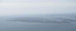
The municipality encompasses all of the island of Radøy, except the far southern tip (which belongs to Lindås municipality. The smaller surrounding islands of Toska, Bognøy, Fesøy, and others are also part of Radøy municipality. The Radfjorden separates Radøy municipality from the municipality of Meland to the south. The Radsundet strait separates the municipality of Radøy from the municipality of Lindås to the east. The island of Fosnøyna (in Austrheim) lies to the north. The islands of Øygarden lie across the Hjeltefjorden to the west.
References
- ↑ "Navn på steder og personer: Innbyggjarnamn" (in Norwegian). Språkrådet. Retrieved 2015-12-01.
- ↑ Jukvam, Dag (1999). "Historisk oversikt over endringer i kommune- og fylkesinndelingen" (PDF) (in Norwegian). Statistisk sentralbyrå.
- ↑ Store norske leksikon. "Radøy. – øy" (in Norwegian). Retrieved 2014-04-15.
- ↑ "Civic heraldry of Norway - Norske Kommunevåpen". Heraldry of the World. Retrieved 2014-04-15.
- ↑ "Kommunevåpen". Flags of the World. 28 June 2002. Retrieved 21 September 2008. External link in
|publisher=(help) - ↑ "Members of the local councils, by party/electoral lists and municipality" (in Norwegian). Statistics Norway. 2011.
- ↑ Kommunestyret