Samnanger
| Samnanger kommune | |||
|---|---|---|---|
| Municipality | |||
 | |||
| |||
 Samnanger within Hordaland | |||
| Coordinates: 60°24′10″N 05°48′20″E / 60.40278°N 5.80556°ECoordinates: 60°24′10″N 05°48′20″E / 60.40278°N 5.80556°E | |||
| Country | Norway | ||
| County | Hordaland | ||
| District | Midhordland | ||
| Administrative centre | Tysse | ||
| Government | |||
| • Mayor (2015) | Knut Harald Frøland (Bygdalista) | ||
| Area | |||
| • Total | 269.07 km2 (103.89 sq mi) | ||
| • Land | 257.47 km2 (99.41 sq mi) | ||
| • Water | 11.6 km2 (4.5 sq mi) | ||
| Area rank | 290 in Norway | ||
| Population (2014) | |||
| • Total | 2,436 | ||
| • Rank | 305 in Norway | ||
| • Density | 9.5/km2 (25/sq mi) | ||
| • Change (10 years) | 4.5 % | ||
| Demonym(s) | Samning[1] | ||
| Time zone | CET (UTC+1) | ||
| • Summer (DST) | CEST (UTC+2) | ||
| ISO 3166 code | NO-1242 | ||
| Official language form | Nynorsk | ||
| Website |
www | ||
|
| |||

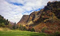
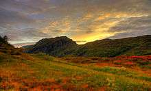
Samnanger is a municipality in the Midhordland region of Hordaland county, Norway. The administrative centre of the municipality is the village of Tysse. Other main villages in the municipality include Haga and Bjørkheim in Nordbygda. The municipality is located about 20 kilometres (12 mi) east of the city of Bergen, Norway's second largest city. It surrounds the inner part of the Samnangerfjorden and the surrounding valleys. There are mountains that surround the municipality. The development of hydroelectric power plants started here in 1909.
General information

The municipality of Samnanger was established on 1 January 1907 when it was separated from the municipality of Os on 1 January 1907. Initially, Samnanger had 3,025 residents. The borders of the municipality have not changed since that time.[2]
Name
The name originally belonged to the fjord (now called the Samnangerfjorden). The meaning of the first element is unknown, and the last element is angr which means "fjord".[3]
Coat-of-arms
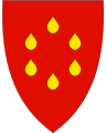
The coat-of-arms is from modern times. They were granted on 27 April 1990. It shows six yellow drops of water on a red field. Water was chosen as a symbol on the arms because of the wet climate and the source of hydroelectricity that is prevalent in the area. The designer of the arms was Even Jarl Skoglund.[4][5]
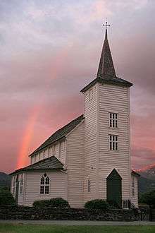
Churches
The Church of Norway has one parish (sokn) within the municipality of Samnanger. It is part of the Hardanger og Voss deanery in the Diocese of Bjørgvin.
| Parish (Sokn) | Church Name | Location of the Church | Year Built |
|---|---|---|---|
| Samnanger | Haga Church | Haga | 1995 |
| Samnanger Church | Ådland | 1851 |
Government
All municipalities in Norway, including Samnanger, are responsible for primary education (through 10th grade), outpatient health services, senior citizen services, unemployment and other social services, zoning, economic development, and municipal roads. The municipality is governed by a municipal council of elected representatives, which in turn elect a mayor.
Municipal council

The municipal council (Kommunestyre) of Samnanger is made up of 21 representatives that are elected to every four years. For 2015–2019, the party breakdown is as follows:[6]
| Party Name | Name in Norwegian | Number of representatives | |
|---|---|---|---|
| Labour Party | Arbeiderpartiet | 5 | |
| Progress Party | Framstegspartiet | 4 | |
| Conservative Party | Høgre | 2 | |
| Christian Democratic Party | Kristelig Folkeparti | 2 | |
| Green Party | Miljøpartiet Dei Grøne | 1 | |
| Centre Party | Senterpartiet | 2 | |
| Local Lists | Lokale lister | 5 | |
| Total number of members: | 21 | ||
Geography
| Historical population | ||
|---|---|---|
| Year | Pop. | ±% |
| 1951 | 2,503 | — |
| 1960 | 2,493 | −0.4% |
| 1970 | 2,180 | −12.6% |
| 1980 | 2,305 | +5.7% |
| 1990 | 2,412 | +4.6% |
| 2000 | 2,282 | −5.4% |
| 2010 | 2,375 | +4.1% |
| 2014 | 2,436 | +2.6% |
| Source: Statistics Norway. | ||
Samnanger lies at the inner end of the Samnangerfjorden. The municipalities of Fusa and Os lie to the south, Bergen is to the west, Vaksdal is to the north, and Kvam is to the east. Samnanger lies on the mainland of Norway, but its western parts lie on the Bergen Peninsula—a large peninsula connected to the mainland by a small isthmus of land running between Trengereid in Bergen and Trengereidfjorden in Samnanger.
The Gullfjellet mountains lie along the western border of the municipality. The mountain Sveningen lies at the tripoint border with Samnanger, Bergen, and Os. The Kvamskogen mountain plateau lies along the eastern border of the municipality.
References
- ↑ "Navn på steder og personer: Innbyggjarnamn" (in Norwegian). Språkrådet. Retrieved 2015-12-01.
- ↑ Jukvam, Dag (1999). "Historisk oversikt over endringer i kommune- og fylkesinndelingen" (PDF) (in Norwegian). Statistisk sentralbyrå.
- ↑ Store norske leksikon. "Samnanger" (in Norwegian). Retrieved 2014-07-13.
- ↑ "Kommunevåpen". Flags of the World. 28 June 2002. Retrieved 21 September 2008. External link in
|publisher=(help) - ↑ "Civic heraldry of Norway - Norske Kommunevåpen". Heraldry of the World. Retrieved 2014-07-13.
- ↑ "Members of the local councils, by party/electoral lists and municipality" (in Norwegian). Statistics Norway. 2015.