Rayland, Ohio
| Rayland, Ohio | |
|---|---|
| Village | |
|
Northern end of Main Street | |
 Location of Rayland, Ohio | |
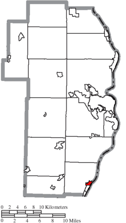 Location of Rayland in Jefferson County | |
| Coordinates: 40°11′0″N 80°41′27″W / 40.18333°N 80.69083°WCoordinates: 40°11′0″N 80°41′27″W / 40.18333°N 80.69083°W | |
| Country | United States |
| State | Ohio |
| County | Jefferson |
| Township | Warren |
| Area[1] | |
| • Total | 0.50 sq mi (1.29 km2) |
| • Land | 0.47 sq mi (1.22 km2) |
| • Water | 0.03 sq mi (0.08 km2) |
| Elevation[2] | 679 ft (207 m) |
| Population (2010)[3] | |
| • Total | 417 |
| • Estimate (2012[4]) | 408 |
| • Density | 887.2/sq mi (342.5/km2) |
| Time zone | Eastern (EST) (UTC-5) |
| • Summer (DST) | EDT (UTC-4) |
| ZIP code | 43943 |
| Area code(s) | 740 |
| FIPS code | 39-65662[5] |
| GNIS feature ID | 1049113[2] |

Rayland is a village in Jefferson County, Ohio, United States, along the Ohio River. The population was 417 at the 2010 census. It is part of the Weirton–Steubenville, WV-OH Metropolitan Statistical Area.
History
Rayland was originally called Portland.[6] A post office called Portland Station was established in 1871, and the name was changed to Rayland in 1905.[7] Rayland was once one of the biggest port towns on the Ohio River. It has served as a safe haven for civil war soldiers to be doctored back to health. Rayland was the scene of several bloody battles fought in the civil war.
Geography
Rayland is located at 40°11′0″N 80°41′27″W / 40.18333°N 80.69083°W (40.183277, -80.690971).[8]
According to the United States Census Bureau, the village has a total area of 0.50 square miles (1.29 km2), of which 0.47 square miles (1.22 km2) is land and 0.03 square miles (0.08 km2) is water.[1]
Demographics
| Historical population | |||
|---|---|---|---|
| Census | Pop. | %± | |
| 1940 | 681 | — | |
| 1950 | 726 | 6.6% | |
| 1960 | 694 | −4.4% | |
| 1970 | 617 | −11.1% | |
| 1980 | 566 | −8.3% | |
| 1990 | 490 | −13.4% | |
| 2000 | 434 | −11.4% | |
| 2010 | 417 | −3.9% | |
| Est. 2015 | 404 | [9] | −3.1% |
2010 census
As of the census[3] of 2010, there were 417 people, 173 households, and 120 families residing in the village. The population density was 887.2 inhabitants per square mile (342.5/km2). There were 188 housing units at an average density of 400.0 per square mile (154.4/km2). The racial makeup of the village was 97.8% White, 1.0% African American, 0.2% Native American, 0.5% from other races, and 0.5% from two or more races.

There were 173 households of which 30.1% had children under the age of 18 living with them, 48.0% were married couples living together, 14.5% had a female householder with no husband present, 6.9% had a male householder with no wife present, and 30.6% were non-families. 23.1% of all households were made up of individuals and 8.7% had someone living alone who was 65 years of age or older. The average household size was 2.41 and the average family size was 2.79.
The median age in the village was 43.7 years. 22.8% of residents were under the age of 18; 4.1% were between the ages of 18 and 24; 25.1% were from 25 to 44; 30% were from 45 to 64; and 18% were 65 years of age or older. The gender makeup of the village was 48.9% male and 51.1% female.
2000 census
As of the census[5] of 2000, there were 434 people, 175 households, and 134 families residing in the village. The population density was 998.9 people per square mile (389.7/km²). There were 198 housing units at an average density of 455.7 per square mile (177.8/km²). The racial makeup of the village was 98.39% White, 0.69% African American, 0.23% Asian, 0.23% from other races, and 0.46% from two or more races. Hispanic or Latino of any race were 0.23% of the population.

There were 175 households out of which 26.9% had children under the age of 18 living with them, 57.1% were married couples living together, 14.3% had a female householder with no husband present, and 23.4% were non-families. 20.6% of all households were made up of individuals and 13.7% had someone living alone who was 65 years of age or older. The average household size was 2.48 and the average family size was 2.84.
In the village the population was spread out with 22.1% under the age of 18, 7.8% from 18 to 24, 23.3% from 25 to 44, 23.0% from 45 to 64, and 23.7% who were 65 years of age or older. The median age was 43 years. For every 100 females there were 80.8 males. For every 100 females age 18 and over, there were 87.8 males.
The median income for a household in the village was $27,386, and the median income for a family was $35,000. Males had a median income of $38,500 versus $19,531 for females. The per capita income for the village was $13,382. About 17.1% of families and 23.3% of the population were below the poverty line, including 40.0% of those under age 18 and 9.6% of those age 65 or over.
Education
Public education in the village of Rayland is provided by the Buckeye Local School District.
See also
References
- 1 2 "US Gazetteer files 2010". United States Census Bureau. Retrieved 2013-01-06.
- 1 2 "US Board on Geographic Names". United States Geological Survey. 2007-10-25. Retrieved 2008-01-31.
- 1 2 "American FactFinder". United States Census Bureau. Retrieved 2013-01-06.
- ↑ "Population Estimates". United States Census Bureau. Retrieved 2013-06-17.
- 1 2 "American FactFinder". United States Census Bureau. Retrieved 2008-01-31.
- ↑ Doyle, Joseph Beatty (1910). 20th Century History of Steubenville and Jefferson County, Ohio and Representative Citizens. Richmond-Arnold Publishing Company. p. 482.
- ↑ "Jefferson County". Jim Forte Postal History. Retrieved 2 January 2016.
- ↑ "US Gazetteer files: 2010, 2000, and 1990". United States Census Bureau. 2011-02-12. Retrieved 2011-04-23.
- ↑ "Annual Estimates of the Resident Population for Incorporated Places: April 1, 2010 to July 1, 2015". Retrieved July 2, 2016.
- ↑ "Census of Population and Housing". Census.gov. Retrieved June 4, 2015.
Municipalities and communities of Jefferson County, Ohio, United States | ||
|---|---|---|
| Cities | 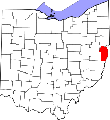 | |
| Villages | ||
| Townships | ||
| CDPs |
| |
| Unincorporated communities |
| |
| Ghost town | ||
| Footnotes | ‡This populated place also has portions in an adjacent county or counties | |
| Counties |  Map of the Pittsburgh Tri-State with green counties in the metropolitan area and yellow counties in the combined area. | |
|---|---|---|
| Major cities | ||
| Cities and towns 15k-50k (in 2010) | ||
| Airports | ||
| Topics | ||
| ||