Reasi district
| Reasi district | |
|---|---|
| District | |
|
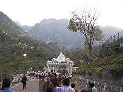
Vaishno Devi temple | |
 Location in Jammu and Kashmir, India | |
| Coordinates: 33°05′N 74°50′E / 33.09°N 74.84°ECoordinates: 33°05′N 74°50′E / 33.09°N 74.84°E | |
| Country |
|
| State | Jammu and Kashmir |
| Established | April 2007 |
| Headquarters | Reasi |
| Area | |
| • Total | 1,719 km2 (664 sq mi) |
| Population (2011)[1] | |
| • Total | 314,667 |
| • Density | 180/km2 (470/sq mi) |
| Demonym(s) | Languages |
| Time zone | IST (UTC+5:30) |
| Website | http://reasi.gov.in/ |
Reasi district (Urdu: ضلع ریاسی ) is a district of the Indian state of Jammu and Kashmir. The Reasi district is bordered by Udhampur district and Ramban district in the east, Jammu district in the south, Rajouri district in the west and by Kulgam district on the north. The Reasi and Rajouri tehsiles formed a joint district called the "Reasi district" at the time of princely state's accession to India in 1947. As part of the reorganisation, the two tehsils were separated and Reasi was merged with the Udhampur district. It again became a separate district in 2006.[2]
Reasi is one of the oldest towns of the Jammu and Kashmir State. It was the seat of the erstwhile Bhimgarh State, said to have been established by Raja Bhim Dev sometime in the 8th century. It remained an independent principality till 1822, when Raja Gulab Singh the then Raja of Jammu hill region, under the Sikh empire, consolidated the small states.
Geography
Reasi is located at a distance of 64 km from Jammu and is bounded by Tehsil Gool-Gulabgarh in the north, Tehsil Sunderbani and Kalakote of District Rajouri in the west, Tehsil Udhampur in the east, Tehsils Jammu and Akhnoor of District Jammu on the south. Reasi sub division has a population of 1,20,380 as per 2001 census with 25.57% Muslims and Hindu majority. Climatically a major part of this Sub-Division falls in sub-tropical zone and the rest in temperate zone. Summers are generally warm and winters cold with snowfall on the high ridges. One of the most beautiful thing about Reasi is that in summers, the temperature of Reasi will be less than most of the districts in Jammu and in winters, its temperature will be higher than other districts in Jammu. So this makes Reasi favourable for all kinds of people visiting there.
Hindu sites
Major Hindu pilgrimage sites like Vaishno Devi, Shiv Khori, Dharsar Baba and Baba Siyad are located in this district. Due to this Reasi district sees a great in-rush of people from all over across the country, especially in summer.
Access
Being far away from Jammu–Udhampur–Srinagar Highway 1-A and somewhat inaccessible due to the hilly area, economic progress in the mostly hilly region of Reasi has been rather slow. With the commissioning of Salal Hydroelectric Project at Dhyangarh near Reasi, the economic activity of the area has picked up considerably. Construction work of this project was started in 1970 by the National Hydro-Electric Power Corporation (NHPC) and the project was commissioned in 1987 when the first stage of 345 Megawatt power station was completed and balance/second stage of the project with 345 MW was commissioned in 1995 making the total generation to 690 MW. Power from this project flows to the Northern Grid from where it is distributed to the states of J&K, Punjab, Haryana, Delhi, Himachal Pradesh, Rajasthan, Uttar Pradesh and Chandigarh.
The Jammu–Srinagar–Baramulla Railway line which is under construction passes through Reasi district. The Railway line up to Katra was inaugurated on July 4, 2014, by the Indian Prime Minister Narendra Modi at Shri Mata Vaishno Devi Katra railway station. From Katra the Railway line traverses to Reasi-Banihal area with stations at Reasi, Salal A–Salal B, Surukot, Barala, Sangaldan, Kohli and Laole. The 1315 meters long railway bridge under construction over river Chenab near Salal with a height of 383.10 meters from the river surface and shall be the highest bridge in the world. This railway line will bring Reasi on the rail map of the country and accelerate development and prosperity in the area.
Demographics
According to the 2011 census Reasi district has a population of 314,667,[3][4] roughly equal to the nation of The Bahamas.[5] This gives it a ranking of 570th in India (out of a total of 640).[4] The district has a population density of 184 inhabitants per square kilometre (480/sq mi).[4] Its population growth rate over the decade 2001-2011 was 27.06%.[4] Reasi has a sex ratio of 891 females for every 1000 males,[4] and a literacy rate of 59.42%.[4] Reasi has a population which is a blend of almost equal percentage of Muslims and Hindus and has set an example for tolerant and peaceful religious co-existence. Reasi's population stands at 314,667 (2011) constituting 49.66% of Muslims and 48.90% of Hindus. The main languages spoken in Reasi are Urdu, Kashmiri, Punjabi, Dogri and Gojri.
History
Bhimgarh Fort
An historical fort named as Bhimgarh Fort, but generally also known as ‘Reasi Fort’ is located in the town of Reasi on a hillock approximately 150 meters high. As per local lore initially the fort was made of clay which later on was reconstructed with stone masonry and was generally used by the royal family for taking shelter during emergencies. Presently the fort is in the charge of the Department of Archaeology, J&K Government since 1989. Today the fort stands out as one of the important landmarks in the town. During the time this was damaged several times due to its age and natural violence. From time to the government understanding the importance of this fort has tried its best to reconstruct it. It's due to this fact that this fort is still standing in Reasi and it adds shine to the Reasi city.
Inside India
After the accession of the princely state of Jammu and Kashmir to India in 1947, the Rajouri and Reasi tehsils of the former "Reasi district" were separated. Rajouri was merged with the Indian-administered Poonch district, India and Reasi was merged with the Udhampur district.
The people of this hilly area have long agitated for the restoration of the district status for Reasi. The Wazir Commission report, among other recommendations, proposed that it be upgraded to a district. Rishi Kumar Koushal, a prominent leader of the erstwhile Jan Sangh, now Bharatiya Janata Party, led the agitation to restore the district status in the late nineties.
Reasi has been upgraded to District level in the year 2007 due to the constant efforts made by the people.
Administration
Reasi district has two tehsils viz., Reasi and Gool-Gulabgarh comprising 239 and 60 villages respectively.
This district consists of 4 blocks: Arnas, Mahore, Reasi and Pouni.[6] Each block consists of a number of panchayats.
Politics
Reasi District has 3 assembly constituencies: Reasi, Gulabgarh and Gool Arnas.[7]
Places of interest
- Bhimgarh Fort
- Shivkhori
- Vaishnodevi
- Kalika Temple
- Baba Dhansar
- Dhyangarh
- Baba Bidda
- Siarh Baba
- Sula Park
- Dera Baba
References
- ↑ Census of India 2011
- ↑ Jammu and Kashmir to have eight new districts, Indo-Asian News Service, 6 July 2006.
- ↑ http://www.censusindia.gov.in/pca/default.aspx
- 1 2 3 4 5 6 "District Census 2011". Census2011.co.in. 2011. Retrieved 2011-09-30.
- ↑ US Directorate of Intelligence. "Country Comparison:Population". Retrieved 2011-10-01.
Bahamas, The 313,312
- ↑ Statement showing the number of blocks in respect of 22 Districts of Jammu and Kashmir State including newly Created Districts dated 2008-03-13, accessed 2008-08-30
- ↑ "ERO's and AERO's". Chief Electoral Officer, Jammu and Kashmir. Retrieved 2008-08-28.
External links
| Wikimedia Commons has media related to Reasi district. |
- Official Website of J&K Govt
- Official Website of Reasi
- Google Maps Reasi
- List of places in Reasi
 |
Kulgam district | Ramban district | | |
| Rajouri district | |
|||
| ||||
| | ||||
| Jammu district | Udhampur district |