Roche à Perdrix
| Roche à Perdrix | |
|---|---|
 | |
| Highest point | |
| Elevation | 2,135 m (7,005 ft) [1] |
| Prominence | 168 m (551 ft) [2] |
| Coordinates | 53°12′45″N 117°48′10″W / 53.21250°N 117.80278°W |
| Geography | |
| Location | Alberta, Canada |
| Parent range | Fiddle Range |
| Topo map | NTS 83F/04 |
| Climbing | |
| Easiest route | moderate scramble |
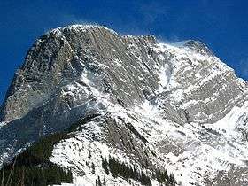
Roche à Perdrix is a mountain in Alberta's Rockies, Canada.
It is located south of Highway 16 on the eastern border of Jasper National Park, and is part of the Fiddle Range, one of the easternmost ranges of the Canadian Rockies. It is one of the first mountains upon entering the park from the east and is directly on the park border. In French, perdrix means partridge and roche means rock. The name is a reference to the rock foliations, which resemble a partridge's tail feathers.[1]
It was named by the Reverend George Grant in 1872. [3]
References
- 1 2 PeakFinder. "Roche à Perdrix". Retrieved 2007-09-01.
- ↑ "Roche a Perdrix". Bivouac.com. Retrieved 2009-01-02.
- ↑ Birrell, Dave (2000). 50 Roadside Panoramas in the Canadian Rockies. Rocky Mountain Books. ISBN 0-921102-65-8.
This article is issued from Wikipedia - version of the 1/8/2013. The text is available under the Creative Commons Attribution/Share Alike but additional terms may apply for the media files.