Roessleville, New York
| Roessleville | |
| hamlet | |
| Official name: Roessleville, New York | |
| Name origin: for Theophilus Roessle | |
| Country | United States |
|---|---|
| State | New York |
| Region | Capital District |
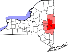
| County | Albany |
| Municipality | Town of Colonie |
| Elevation | 243 ft (74 m) |
| Coordinates | 42°41′42″N 73°48′27″W / 42.69500°N 73.80750°WCoordinates: 42°41′42″N 73°48′27″W / 42.69500°N 73.80750°W |
| Area | 2.89 sq mi (7 km2) |
| - land | 2.88 sq mi (7 km2) |
| - water | .01 sq mi (0 km2) |
| Population | 10,753 (1990) |
| Density | 1,433.7/sq mi (554/km2) |
| Settled | 1840 |
| Timezone | EST (UTC-5) |
| - summer (DST) | EDT (UTC-4) |
| ZIP Code | 12205 |
| Area code | 518 |
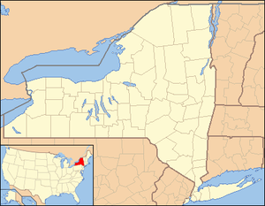 Location of Roessleville within the state of New York | |
Roessleville is a hamlet in the town of Colonie, Albany County, New York. It is a densely settled suburb of the city of Albany along New York State Route 5. Roessleville was a census-designated place in the 1990 Census, but was deleted in 2000.[1]
History
Originally Roessleville was part of the Pine Bush pine barrens that stretched from Albany to Schenectady, the land later became farmland in the 1940s and then more recently into a densely packed suburb.[2] Roessleville is named for Theophilus Roessle, a German immigrant from the Kingdom of Württemberg, who built one of the most elegant mansions in the Albany area in what is now Roessleville, today's Elmhurst Avenue was once his gated driveway.[2][3] Two of the most famous residents of Roessleville was Josiah and Elizabeth Stanford; parents of Governor of California Leland Stanford; who moved the entire family here in 1840 and owned the Elm Grove Farm and hotel.[4]
Geography
Roessleville is that section of the town of Colonie between Osborne and Wolf roads, it is bisected by Central Avenue (NY Route 5).[2] The Albany city line is along its southeastern border, the village of Colonie is along its northwestern boundary at Wolf Road. The census-designated place of Roessleville, as defined by the US Census Bureau for 1990, was 2.9 square miles (7.5 km2) in area.[5]
Location
 |
Village of Colonie | Hamlet of Loudonville | | |
| |
Hamlet of West Albany | |||
| ||||
| | ||||
| Town of Guilderland | Town of Guilderland/City of Albany Interstate 90 |
City of Albany |
Demographics
| Historical population | |||
|---|---|---|---|
| Census | Pop. | %± | |
| 1970 | 5,476 | — | |
| 1980 | 11,685 | 113.4% | |
| 1990 | 10,753 | −8.0% | |
Since hamlets are by definition ill-defined any attempt at accurate calculations of population related statistics will be difficult or inaccurate. As a census-designated place (CDP) prior to 2000 however Roessleville did have definitive boundaries, though they did change over time from one census to another. Roessleville was not a CDP in 1960, but was in 1970 when it had 5,476 persons which included 125 in a small slice of the town of Guilderland;[6] the Guilderland section was not included in 1980,[7] and in 1990 Roessleville had a population of 10,753.[5]
References
- ↑ 2000 census of population and housing: Population and housing unit counts, Issues 19-23. United States Bureau of the Census. 2003.
- 1 2 3 Frances Ingraham (September 11, 1994). "Roessleville Evolved from Pine Bush, Farmland". Albany Times Union. Retrieved 2010-02-13.
- ↑ George Howell and Jonathan Tenney (1886). Bi-Centennial History of Albany: History of the County of Albany from 1609-1886. W.W. Munsell and Company. p. 935. Retrieved 2010-02-10.
- ↑ Schenectady County Historical Society (2009). Niskayuna. Arcadia Publishing. p. 72. ISBN 978-0-7385-6536-1. Retrieved 2010-02-13.
- 1 2 "Table 5: Land Area and Population Density: 1990" (PDF). US Bureau of the Census. p. 39. Retrieved 2010-02-13.
- ↑ 1970 Population: Volume 1; Characteristics of the Population. US Census of the Bureau. 1970. p. 3423.
- ↑ 1980 Census of Population; Volume 1: Characteristics of the Population. US Bureau of the Census. 1980. p. 34-10. Retrieved 2010-02-13.
Municipalities and communities of Albany County, New York, United States | ||
|---|---|---|
| Cities | 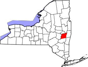 | |
| Towns | ||
| Villages | ||
| CDPs | ||
| Other hamlets |
| |