Saint-Gengoux-le-National
| Saint-Gengoux-le-National | ||
|---|---|---|
 | ||
| ||
 Saint-Gengoux-le-National | ||
|
Location within Bourgogne-Franche-Comté region  Saint-Gengoux-le-National | ||
| Coordinates: 46°36′53″N 4°39′49″E / 46.6147°N 4.6636°ECoordinates: 46°36′53″N 4°39′49″E / 46.6147°N 4.6636°E | ||
| Country | France | |
| Region | Bourgogne-Franche-Comté | |
| Department | Saône-et-Loire | |
| Arrondissement | Mâcon | |
| Canton | Saint-Gengoux-le-National | |
| Intercommunality | Entre Grosne et Guye | |
| Government | ||
| • Mayor (2008–2014) | Joêl Pierre | |
| Area1 | 9.36 km2 (3.61 sq mi) | |
| Population (2006)2 | 1,085 | |
| • Density | 120/km2 (300/sq mi) | |
| Time zone | CET (UTC+1) | |
| • Summer (DST) | CEST (UTC+2) | |
| INSEE/Postal code | 71417 / 71460 | |
| Elevation |
193–390 m (633–1,280 ft) (avg. 232 m or 761 ft) | |
|
1 French Land Register data, which excludes lakes, ponds, glaciers > 1 km² (0.386 sq mi or 247 acres) and river estuaries. 2 Population without double counting: residents of multiple communes (e.g., students and military personnel) only counted once. | ||
.svg.png)
Saint-Gengoux-le-National is a commune in the Saône-et-Loire department in the region of Bourgogne in eastern France.
It was formerly known as Saint-Gengoux-le-Royal.
History

In the 10th century, the church of Saint-Gengoux was given to the abbey of Cluny. In the 12th century, the abbot of Cluny requested king Louis VII install a lord of the manor with Saint-Gengoux in order to ensure the safety of the city.
At the revolution, Saint-Gengoux-le-Royal took the name of Saint-Gengoux-le-National. It reverted to Saint-Gengoux-le-Royal is 1834, Saint-Gengoux-le-National in 1848, Saint-Gengoux-le-Royal in 1852 before finally settling on Saint-Gengoux-le-National in 1881.
Geography
The river Grosne forms part of the commune's south-eastern border.
Notable buildings
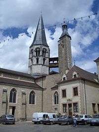
The church was built in 1120 by the Benedictines of Cluny. It measures 41 m in length and 16 m wide. It was plundered several times and has been heavily restored. The most recent enhancement has been the replacement of the metal bridge between the towers with a wooden one, more in keeping with the Burgundian style. In 1802, three vaults contiguous to the church were destroyed to build a corn exchange on their site.
There are many historic properties from the sixteenth and seventeenth centuries.
Transport
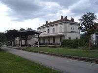
The railway station at Saint-Gengoux-le-National was opened in 1880 on the Chalon-sur-Saône to Mâcon railway line.
After the closure of the railway, in 1996 the 44 km of trackbed from Givry to Cluny has been paved and converted into a cycle route known as the Voie Verte. There are several locations along the route where cycles may be hired, including the station at Saint-Gengoux-le-National.
See also
References
- Histoire de Saint Gengoux le Royale, Marie de Saint Gengoux le National, 2005.
External links
| Wikimedia Commons has media related to Saint-Gengoux-le-National. |