Solutré-Pouilly
| Solutré-Pouilly | |
|---|---|
 | |
 Solutré-Pouilly | |
|
Location within Bourgogne-Franche-Comté region  Solutré-Pouilly | |
| Coordinates: 46°17′47″N 4°43′29″E / 46.2965°N 4.72470°ECoordinates: 46°17′47″N 4°43′29″E / 46.2965°N 4.72470°E | |
| Country | France |
| Region | Bourgogne-Franche-Comté |
| Department | Saône-et-Loire |
| Arrondissement | Mâcon |
| Canton | Mâcon-Sud |
| Area1 | 6.16 km2 (2.38 sq mi) |
| Population (2006)2 | 401 |
| • Density | 65/km2 (170/sq mi) |
| Time zone | CET (UTC+1) |
| • Summer (DST) | CEST (UTC+2) |
| INSEE/Postal code | 71526 / 71960 |
| Elevation |
208–530 m (682–1,739 ft) (avg. 400 m or 1,300 ft) |
|
1 French Land Register data, which excludes lakes, ponds, glaciers > 1 km² (0.386 sq mi or 247 acres) and river estuaries. 2 Population without double counting: residents of multiple communes (e.g., students and military personnel) only counted once. | |
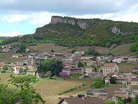
Solutré-Pouilly is a commune in the Saône-et-Loire department in the region of Bourgogne in eastern France. It is known for a local geological feature, the Rock of Solutré.
Wine
The vineyards of Solutré-Pouilly are part of the appellation d'origine contrôlée Pouilly-Fuissé. Local wineries include the Domaine du Chalet Pouilly.
Points of interest
See also
- Solutrean, the Paleolithic style named after a site near the village.
- Communes of the Saône-et-Loire department
- Rock of Solutré
References
| Wikimedia Commons has media related to Solutré-Pouilly. |
This article is issued from Wikipedia - version of the 10/28/2016. The text is available under the Creative Commons Attribution/Share Alike but additional terms may apply for the media files.