Berzé-le-Châtel
| Berzé-le-Châtel | |
|---|---|
|
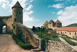
Castle at Berzé | |
 Berzé-le-Châtel | |
|
Location within Bourgogne-Franche-Comté region  Berzé-le-Châtel | |
| Coordinates: 46°23′07″N 4°41′24″E / 46.3853°N 4.69°ECoordinates: 46°23′07″N 4°41′24″E / 46.3853°N 4.69°E | |
| Country | France |
| Region | Bourgogne-Franche-Comté |
| Department | Saône-et-Loire |
| Arrondissement | Mâcon |
| Canton | Cluny |
| Intercommunality | Clunisois |
| Area1 | 5.53 km2 (2.14 sq mi) |
| Population (2006)2 | 64 |
| • Density | 12/km2 (30/sq mi) |
| Time zone | CET (UTC+1) |
| • Summer (DST) | CEST (UTC+2) |
| INSEE/Postal code | 71031 / 71960 |
| Elevation |
304–590 m (997–1,936 ft) (avg. 349 m or 1,145 ft) |
|
1 French Land Register data, which excludes lakes, ponds, glaciers > 1 km² (0.386 sq mi or 247 acres) and river estuaries. 2 Population without double counting: residents of multiple communes (e.g., students and military personnel) only counted once. | |
Berzé-le-Châtel (Old French: Barzil) is a commune in the Saône-et-Loire department in the region of Bourgogne in eastern France.
The trouvère Hugues IV de Berzé was the ruler of Berzé-le-Châtel in the early 13th century.
It is said that the Berzé-le-Châtel's basement extends 1000 feet into the ground.
See also
References
External links
| Wikimedia Commons has media related to Berzé-le-Châtel. |
This article is issued from Wikipedia - version of the 10/28/2016. The text is available under the Creative Commons Attribution/Share Alike but additional terms may apply for the media files.