Saint-Sernin-sur-Rance
| Saint-Sernin-sur-Rance | ||
|---|---|---|
|
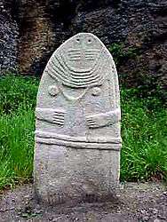
Menhir La Dame de Saint-Sernin | ||
| ||
 Saint-Sernin-sur-Rance | ||
|
Location within Occitanie region  Saint-Sernin-sur-Rance | ||
| Coordinates: 43°53′06″N 2°36′15″E / 43.885°N 2.6042°ECoordinates: 43°53′06″N 2°36′15″E / 43.885°N 2.6042°E | ||
| Country | France | |
| Region | Occitanie | |
| Department | Aveyron | |
| Arrondissement | Millau | |
| Canton | Saint-Sernin-sur-Rance | |
| Intercommunality | Pays Saint-Serninois | |
| Government | ||
| • Mayor (2008–2014) | Annie Bel | |
| Area1 | 11.14 km2 (4.30 sq mi) | |
| Population (2008)2 | 674 | |
| • Density | 61/km2 (160/sq mi) | |
| Time zone | CET (UTC+1) | |
| • Summer (DST) | CEST (UTC+2) | |
| INSEE/Postal code | 12248 / 12380 | |
| Elevation |
288–662 m (945–2,172 ft) (avg. 290 m or 950 ft) | |
|
1 French Land Register data, which excludes lakes, ponds, glaciers > 1 km² (0.386 sq mi or 247 acres) and river estuaries. 2 Population without double counting: residents of multiple communes (e.g., students and military personnel) only counted once. | ||

Saint-Sernin-sur-Rance is a commune in the Aveyron department in southern France.
Population
| Historical population | ||
|---|---|---|
| Year | Pop. | ±% |
| 1962 | 692 | — |
| 1968 | 693 | +0.1% |
| 1975 | 632 | −8.8% |
| 1982 | 604 | −4.4% |
| 1990 | 563 | −6.8% |
| 1999 | 530 | −5.9% |
| 2008 | 674 | +27.2% |
See also
References
| Wikimedia Commons has media related to Saint-Sernin-sur-Rance. |
This article is issued from Wikipedia - version of the 2/23/2013. The text is available under the Creative Commons Attribution/Share Alike but additional terms may apply for the media files.